See on Scoop.it – Geography Education

BBC News takes a look at who makes up the cast of thousands behind the sporting event of the year.
The Olympics are a massive undertaking with both local and international impacts.
See on www.bbc.co.uk
See on Scoop.it – Geography Education
BBC News takes a look at who makes up the cast of thousands behind the sporting event of the year.
The Olympics are a massive undertaking with both local and international impacts.
See on www.bbc.co.uk
See on Scoop.it – Geography Education
Check out the latest videos on TIME.com…
What geographic factors (economic, cultural and environment) traits contribute to the that lead a long-standing and vibrant camel trade in India? Pushkar is home to the world’s largest camel fair, but is undergoing serious changes. Not surprisingly, less open spaces and modernization are changing the traditional patterns of animal husbandry and the industry is drying up.
See on www.time.com
See on Scoop.it – Geography Education
GeoFRED is an economic data mapping tool which displays color-coded data on the state, MSA, and county levels. For example, GeoFRED can display unemployment, labor force, and population for all U.S. counties.
This is a great “GIS-lite” website with customizable map layers, scale references for a diverse set of economic data.
See on geofred.stlouisfed.org
See on Scoop.it – Geography Education
The Unrepresented Nations and Peoples Organization (UNPO) is not affiliated with the United Nations (UN). The UNPO seeks to represent nations (as opposed to states) that are not fully autonomous are without a vote in the UN. This group, by supporting all ethnic groups in their pursuit for political self-determination, economic empowerment and environmental resource control, is an excellent source for case studies in devolution, ethnic conflicts, indigenous peoples and many issues from both cultural and political geography.
See on unpo.org
See on Scoop.it – Geography Education
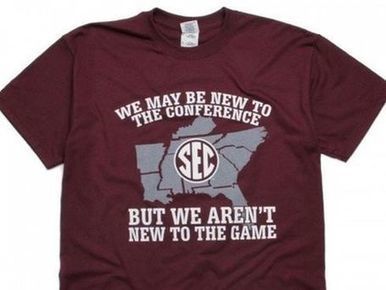
Texas A&M University is about to go on a journey, a journey that will take them far from home. They’re about to enter the Deep South, unfamiliar territory for most Aggies. So in addition to…
Not the worst mistake here, because failing to include the two incoming states might have deliberate. However, including North Carolina (without any SEC teams and firmly in the heart of ACC country) is a bit of a geographical gaffe.
See on www.widerightnattylite.com
Via Scoop.it – Geography Education
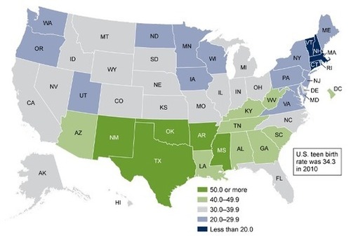
Teen births follow the same fault lines of religion, politics, and class that divide Americans. …
What cultural, economic and political patterns can we see in this map? What else might help us understand these spatial patterns? The rates of highest teen births appear to be correlated with the ‘Bible Belt.’ Why might this be?
Via Scoop.it – Geography Education
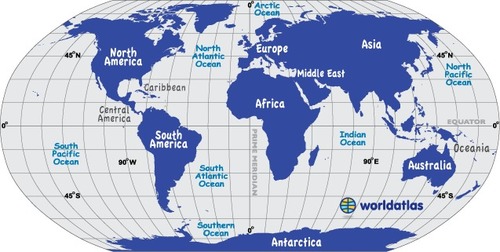
World Atlas is an educational resource for world maps, atlases, and in-depth geography information. Teachers and students: free maps of Europe, USA, Canada, Florida, Caribbean Islands and much more.
This World Atlas, in addition to have many maps at a variety of scales as is very common these days, has the added feature of embedding facts and other informative features based on your scale and regional context. Students can explore this at their own pace to learn about what every region of the world that interests them the most.
Via Scoop.it – Geography Education
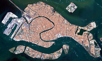
This website houses the past research, images and future missions of the European Space Agency. The greatest scientific knowledge we have gained through the space program is actually about our home planet. Space-age technologies literally give geographers a chance to step back and put the Earth in better perspective. Images from this site are fantastic resource use to teach the thematic content, but also it is a great resource to show the relevance of geospatial technologies. I love this particular image of Venice. For more see: www.esa.int