See on Scoop.it – Geography Education
This video is a good primer to show before the ReDistricting Game (http://www.scoop.it/t/geography-education/p/2214122954/the-redistricting-game ).
See on www.youtube.com
See on Scoop.it – Geography Education
This video is a good primer to show before the ReDistricting Game (http://www.scoop.it/t/geography-education/p/2214122954/the-redistricting-game ).
See on www.youtube.com
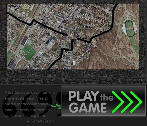
See on Scoop.it – Geography Education
This is an interactive way to teach the importance of the redistricting process. Mapmakers (and geography) are crucial to the process. This game shows students how the process can be manipulated and if you understand local demographics and voting patterns, subtle shifts in the district borders can swing elections. This is a great way to teaching gerrymandering and how political cartography can be.
See on redistrictinggame.org
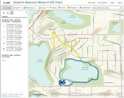
See on Scoop.it – Geography Education
“Now that it is easy to gather tracks and waypoints on a smartphone and map them in a GIS, it provides a good opportunity to remind students about the importance of being critical of and paying attention to data. I recently went on a walk around a local reservoir and used the Motion X GPS app on my iPhone to collect my track and a few waypoints. I emailed the data to myself and added the GPX file to ArcGIS Online so I could map and examine the track. I made my results public and made it visible below to feature some teachable moments……”
See on blogs.esri.com
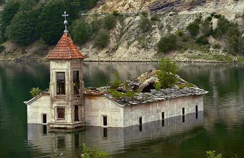
See on Scoop.it – Geography Education
The majority of these ‘drowned buildings’ are the direct result of decisions to dam a river and create a reservoir, create hydroelectricity, etc. How should we analyze this type of cultural landscape? What does it ‘say’ about the multiple groups that have contributed to this layered, complex landscape? Pictured here is the St. Nicolas Church in Macedonia, an 1850 building that is losing to the unrelenting 2003 reservoir that at times fully submerges the building.
See on www.theworldgeography.com
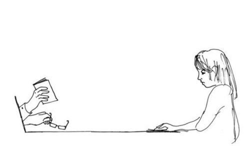
See on Scoop.it – Social Media Classroom
Internet courses are monologues. True learning is a dialogue.
Online education is a paradigm shift for many, one that I encourage…but must it be the paradigm shift for all? There are strengths and weaknesses in both face-to-face and online education…I still prefer to have a classroom and infuse that with digital communication.
See on www.nytimes.com
See on Scoop.it – Geography Education
“Activities that help young minds go global.”
This website is especially good for elementary school teachers that are looking for ways to globalize their students educational experiences. They have activities and resources that are regionally organized–check it out!
See on kidworldcitizen.org
See on Scoop.it – Geography Education
It’s not two photos stitched together, and it’s not an installation. This red line is the stain of toxic sludge.
This is a great issue that highlights the human-environmental interactions theme. In 2011, this site in Hungary witnessed a horrific toxic sludge spill at an aluminum oxide plant that literally created a toxic mudslide.
See on www.npr.org
See on Scoop.it – Geography Education
“EarthView is an educational outreach project of the Department of Geography at Bridgewater State University.”
Bridgewater State is home to the Massachusetts Geographic Alliance and home to Project Earthview (I’ve never been so jealous of a globe before). This inflatable, hand-painted globe in a fantastic teaching resource. You can even enter the globe with a group under 20 and explore the Earth from the inside out. The link is to the Earthview blog, with provides information of the project to take this globe to local schools, and other geographic resources. UPDATE: This event was televised by WGGB in a short 4 minute clip.
See on www.bridgew.edu
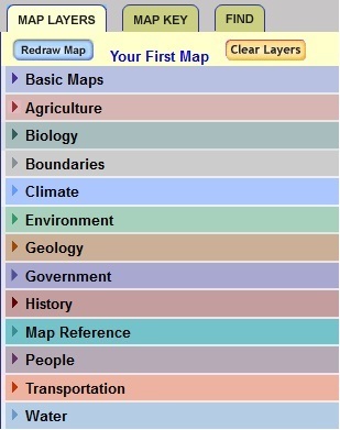
See on Scoop.it – Geography Education
The National Atlas that is available online has an extensive database for simple online mapping. This is “GIS-light,” an easy way to explore the spatial patterns within U.S. census data and other data sets. The lists all contain a wide variety of variables, making this a good way to get students to explore potential research topics. Thanks to the Connecticut Geographic Alliance coordinator for suggesting this link.
See on nationalatlas.gov