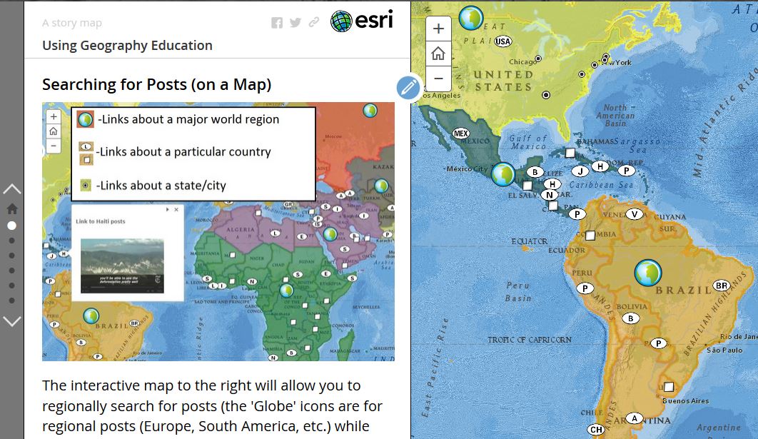
Looking for Regional Geography Readings? Simply click on the link that corresponds to your module to see readings tags associated with that region. You will see the first 10-ish posts, and if you are still looking for more reading options, you can click on “OLDER POSTS” to find more possible readings.
If you want thematic tags or some country-specific resources, scroll to the bottom of the site for an alphabetical list of pertinent geographic topics and countries.
“Since 1970, Western Sahara, perched on the Atlantic coast, has been a combat zone. On one side, Morocco has steadily consumed more and more territory and relocated many thousands of its own citizens to populate it. On the other, an insurgent movement called the Polisario Front, representing the area’s ethnic Sahrawi population, has been pushed further and further into the open desert, propped up by a foreign sponsor in Algeria that has never had the strength to truly turn the tide. Today, the Western Sahara conflict appears to be drawing to a close. After fifty-five years of continuous asymmetric warfare, Morocco is poised to achieve the victory it has pursued for so long. After years of accumulating clout and diplomatic momentum, Morocco has managed to put before the Polisario Front an offer that is exceedingly difficult to refuse. If the Polisario raises the white flag, it will not merely have agreed to end the independence movement that its fathers and grandfathers fought for. It will be sending a very clear signal to the rest of the world about how the business of peace gets done in the twenty-first century.” SOURCE: War Fronts
My entire life, the African coast just south of Morocco was always nebulous spot of the map. Sometimes it was referred to as Western Sahara, sometimes Spanish Sahara, maybe shown as controlled by Morocco, but on many global maps, this is one of those infamous places that shows up blank with “no data.” What is the situation is this mysterious place? This video gives not only a solid overview of the historical background, but is the 2026 update that this ambiguity is now solidifying into a new reality; internationally more states are recognizing new situation with this now being recognized as a part of Moroccan territory.
Since 1973, the ethnic Sahwari have been fighting for independence under the banner of the Polisario Front, but when Spain pulled out in 1975 after a century of colonization, Morocco moved into that power vacuum. The Sahwari are a nomadic people in the western Sahara, meaning they control any large population centers with a scattered small population away from the coast in the desert. The 20th and 21 century economic geography has not been to the advantage of traditional nomadic cultures to maintain political prominence as urbanization and industrialization advantages sedentary, specialized societies. Morocco has controlled that majority of the old Spanish Saharan colony, but exerting control over the expansive desert with insurgents is difficult.
Morocco is now using diplomatic means to fully secure all of this territory under their control. With Algeria as the Polisario Front’s only real backer, Morocco has been working on getting recognition from France, Spain, and the United States with some concessions. Morocco now has most countries recognizing it’s sovereignty claims and is offering amnesty to the Sahwaris living in exile to return. While not everything is completely finalized, this looks like a new status quo and the 55 year war front will be closed.
QUESTIONS TO PONDER: Why was Morocco able to exert more political power in these lands than the Polisario Front? What does this tell us about political power in the 21st century?
-A small group of countries saw explosive population growth, led by Qatar with an increase of over 400% since 2000.
-Most countries grew, but nearly 1 in 7 experienced population decline.
-The sharpest declines were concentrated in Eastern Europe, led by Ukraine at -32.5%.
The map, combines with the charts below of population growth as well as some localized population declines tell so many stories with distinct region explanations. What patterns do you notice in the data? What explanatory factors help you to explain why the patterns look the way they do? For Eastern Europe specifically, what combination of factors leads this to be a region of declining population? What leads those in the chart far below to experience high levels of out-migration?
“Soviet irrigation projects diverted the two great rivers feeding the Aral Sea, and over a few decades the water collapsed, the fishing towns died, and toxic dust storms swept the exposed seabed. We trace how the disaster unfolded, why it became a byword for human-caused ecological catastrophe — and then how a single, focused piece of engineering changed the story in the north. But here’s the twist: the fix wasn’t some vast, impossible re-flooding of the entire sea. It was a dam — the Kok-Aral Dam, completed in 2005 — that concentrated the remaining river flow into the smaller North Aral Sea. Within a few years the water rose, the salinity dropped, the fish returned, and the fishing communities along the northern shore came back to life. We cover what the recovery actually achieved, why the larger southern sea remains mostly lost, and what this divided outcome reveals about what restoration can and can’t do. This is the full story — the collapse, the science, and the surprising truth about the sea that came back from the dead.” SOURCE: Dr. Edmund Hale on YouTube
For years, I taught about the Aral Sea as a cautionary tale of how devastating poor environmental choices can be, and how long reaching the impacts can be. True, the Uzbek side of the Aral Sea is still a mess, but this video shows just how Kazakhstan did what was unthinkable in the 1990s…save their side of the Aral Sea. All the experts said that the damage was irreversible, the devastation too catastrophic and widespread to solve decades of Soviet water mismanagement in a desert ecosystem. This is now a case-study in how small and simple things within our stewardship can bring about great things to come to pass. This video shows how a simple idea damming the water flow could restore Kazakhstan’s lake, ecosystems, fishing industry, and so much more.
Sometimes we act as if all the people can do to the environment is ruin it, and that leaving it alone is the only option for restoration. Admittedly that is an important action for many situations, but we can use our ingenuity, technology, and energy to improve physical environments that have been depreciated. This positive outlook show that human agency can be a force for environmental good while improving the living conditions for our populations.
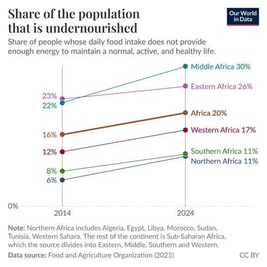
“Hunger levels have increased across Africa over the last decade—In every region of Africa, hunger is more prevalent than a decade ago.The chart shows the increase in the share of the population that is undernourished, comparing 2014 and 2024 (the most recent year available). These estimates come from the Food and Agriculture Organization of the United Nations.The situation across Africa is dire. In Middle Africa, where hunger is most acute, almost 1 in 3 people are undernourished. In Eastern Africa, the figure is roughly 1 in 4. Across Africa as a whole, it’s 1 in 5. This marks a reversal of a longer positive trend: over the preceding decades, hunger had been falling across much of the world, including parts of Africa. That progress has now stalled or gone into reverse. Conflict, extreme weather, and the economic disruption of the COVID-19 pandemic have all contributed.” SOURCE: by Esteban Ortiz-Ospina from OUR WORLD IN DATA
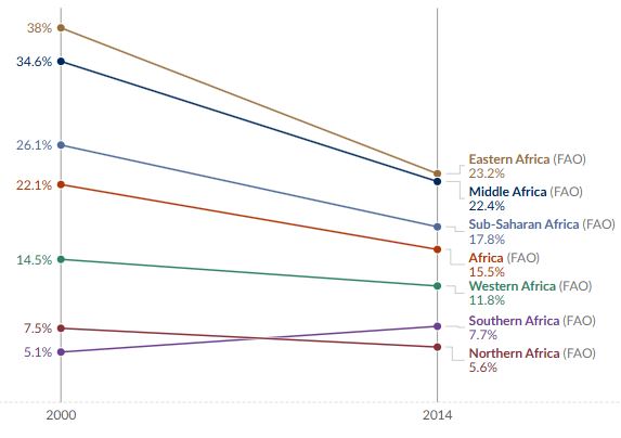
By many metrics, things are improving across the world, but it is important to not when they are not. What areas aren’t seeing improvements? In what ways are issues getting worse? For which populations and in which places are these issues most noticeable? These are questions geographers need to ask and the folks at Our World In Data are an invaluable resource for geography educators to not simply rely on what were learned back in college or narratives we hear in the news, but using current information about how the world actually is today. Hunger and nutrition from 2000-2014, most of Africa saw incredible progress, but since 2014, progress has stalled. Still better that than 2000-levels of hunger, but sustained progress is certainly a hope for the continent that is currently the least developed. What to learn why? Here is an article from Health Policy to explain these complex regional patterns that include economic, environmental, and political dynamics.
“Ever wondered what would happen if Oceania united? This Outer Side video dives deep into the potential unification of the Pacific islands, exploring the geopolitical and power a unified Oceania could hold. This video covers the cultural, geographical challenges and benefits to climate change of creating a single country from this vast and diverse region. Imagine a world where the vast, scattered islands of Oceania, from the oceanic coastlines, remote coastlines to the notable countries, are no longer separate entities. A world where a single flag flies over a united continent, stretching across the Pacific. What kind of power would emerge from such a union today? Join Outer Side as we journey through this captivating ‘what if’ scenario, exploring the untold story of a unified Oceania. What if, one day, the people of Oceania decided to become one?” SOURCE: Outer Side
People love counterfactual histories. What if Europeans didn’t find the New World? What if the U.S. didn’t drop the bomb to end WWII? What if the South won the Civil War? These counterfactual histories force of to consider plausible scenarios, consider how connections and networks would be different if a single detail were different. I think counterfactual geographies is also a help us to reconsider why things are the way they are.
Oceania is an incredibly vast and diverse region, with four main regions and thousands of islands across the Central and South Pacific Oceans. Understanding the complexity and many different parts that make up Oceania is necessary to successfully complete the related coursework. If all these smaller parts united into one, it would become the most powerful multi-cultural region in the world.
Questions to Ponder: What advantages for some island nations would there be to be a part of a larger Oceania? What geographic forces have prevented something like this from happening in the past?
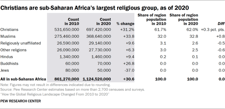
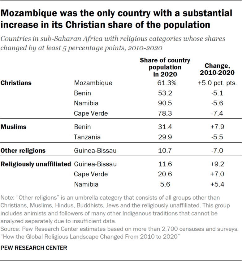
“Most people living in the region are Christians (62%), while Muslims make up about a third of the population. Religiously unaffiliated people and followers of other religions (which include African traditional religions) each account for roughly 3% of the overall population.” SOURCE: Pew Research
This is significant because Sub-Saharan Africa is a younger population with a higher fertility rate so most of global population growth will be coming from this critical region. This chart is an excellent stimulus with data that could be used for multiple choice or a free response questions to get students to evaluate content that they haven’t yet seen. The chart below would change the scale of analysis to then see how religion has changed in a few highlighted countries, which would be an starting point for more research. Which country’s story sparks some curiosity in you?
The next big earthquake will inevitably come, but predicting exactly when a giant earthquake will come is impossible. The three-and-a-half minute CBC video explains why multiple pieces and tears complicates our predictive abilities to forecast plate tectonics down to the year; focused on the impact that this earthquake will have on southern British Columbia. That physical certainty combined with temporal uncertainty makes for difficult messaging; it’s thought to expect people to brace for impending doom if it might not come in their lifetimes. That uncertainty leads many to not prepare for it as an inevitable because it easier to ignore. This 2015 New Yorker article also nicely lays out the context of the “really big one.”
Below is a PBS video that spends the first 7 minutes of the geographic context of the impending “Big One” that will hit Cascadia (another name for the coastal Pacific northwest with the Cascade Mountains). The remainder video focuses on personal and communal emergency preparation which requires a lot of situational awareness. For example, are you in a new building or an old building? Are you in higher floors of a tall building? What utility connections might be damaged? Knowing your own personal geography helps to inform your safety plan.
As a geography educator who loves trivia and finding ways to make spatial thinking entertaining, games like Geoguessr and Timeguessr are right in my wheelhouse. These videos replicate the competitive experience using spatial information, using aerial photography zoomed in to a city and slowly zooming out to see if you can recognize the city from up above. Recognizing the coast or river is often an important way to discern which city you are analyzing. Can you tell the climate from the vegetation patterns? How is the city laid out? How is this layout similar to other cities that were created in the same region? What does the transportation network say about the public policies and technological context of this city? So many clues, but only 15 second to process all of it.
Fair warning, the hard ones are quite hard. I wouldn’t recommend showing these entire video in front of a classroom without some editing…choose the examples that are more locally relevant to your students and at their difficulty level. If you do need some more difficult examples, the state capitals example is quite hard.
If you are ready to branch out from “just” cities, try this video on the 20 landmarks in the United States.
And another one…just because. Find the ones that you like, with the formal and difficult that work for your situation.
This isn’t JUST about carrots and carrot production. We see a similar amount of intensive, mechanistic inputs needed for large-scale production, whether it is in the corn fields of the Midwest, or the oranges groves of Florida. Too often we fail to recognize the sophistication that is a part of every step in the agricultural, industrial, marketing, and distribution of the foods that we eat. The video is long, but the section from 1:50-3:00 that shows how humans aren’t needed in the harvesting process.
The marketing and branding behind “baby carrots” is brilliant, and the euphemism conceals with unnaturalness of the entire process.