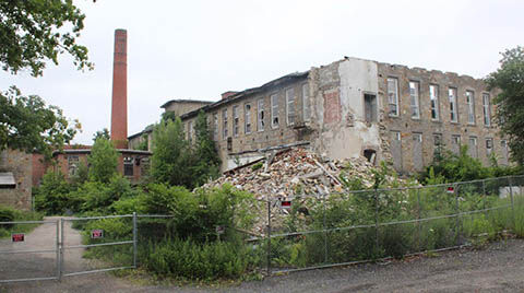
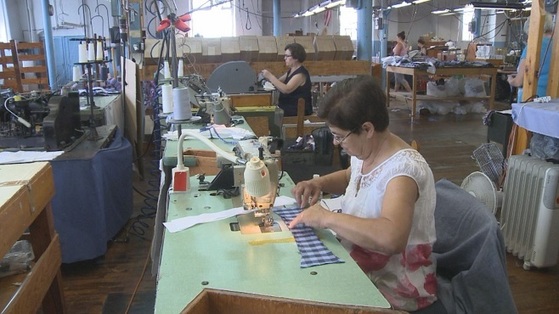
Search

GEOGRAPHY EDUCATION

Supporting geography educators everywhere with current digital resources.

Tag

RhodeIsland

Refugees in a New Home

An Eritrean family reunited in Providence, RI.

Usually when we are talking about refugee topics, we think about it the immediate problems in refugee camps and the conclusion of all these problems will be resettlement of the refugees to a safer place…or so we think.  I love this video for so many reasons, but especially because it concentrates on the many obstacles confronting refugees AFTER they are resettled in a new country.  This documentary, Home Across Lands (FULL 1-hour version available here. The 8-minute version is available on Vimeo) was produced a little over 10 years ago by a Pawtucket, Rhode Island-based film company. This film is an intensely local portrayal of the many difficulties for refugees in a new country. Many haven’t heard about Eritreans refugee camps in Ethiopia, but this article from the Irish Times will give some context on the issue.

Questions to Ponder:

1-Why did so many of the Kumana need to leave Eritrea?    

2-What were the economic difficulties of living in the Shimelba refugee camp?

3-What are some some of the political/legal challenges for refugees in a refugee camp?

3-What are some of the cultural struggles for refugees upon arriving to the United States?

4-What are some of the economic difficulties for refugees upon arriving to the United States?

5-How does the fact of refugees leaving impact their original homeland and it’s culture? How does the fact of refugees arriving to a new place impact their new home?

GeoEd Tags: RhodeIsland, refugees, population, migration.

The water tap at the Shimelba refugee camp

Why does the misperception that slavery only happened in the southern United States exist?

//cdn.embedly.com/widgets/media.html?src=https%3A%2F%2Fplayer.vimeo.com%2Fvideo%2F217064279&dntp=1&wmode=opaque&src_secure=1&url=https%3A%2F%2Fvimeo.com%2F217064279&image=https%3A%2F%2Fi.vimeocdn.com%2Fvideo%2F636139782_1280.jpg&key=25394e42b38f11e0ae3f4040d3dc5c07&type=text%2Fhtml&schema=vimeo

“Christy Clark-Pujara research focuses on the experiences of black people in British and French North America in the seventeenth, eighteenth and early nineteenth centuries. She examines how the business of slavery—the buying and selling of people, food, and goods—shaped the experience of slavery, the process of emancipation, and the realities of black freedom in Rhode Island from the colonial period through the American Civil War.”

Source: vimeo.com

This is one of the many videos produced by the Choices Program about slavery in the New England (especially Rhode Island).  Featured in the videos is Dr. Christy Clark-Pujara, who wrote “Dark Work: The Business of Slavery in Rhode Island.”  There is a reason to what we learn in history, and there are also reasons to the histories that are rarely told.  More than any other of the original thirteen colonies and states along the Eastern Seaboard, Rhode Island plied the triangle trade transporting more slaves to the Americas than all the other states combined.


Some Rhode Island slavery facts:

  • In 1776, Rhode Island had the largest proportion of slave population of any of the New England colonies.
  • During the antebellum period Rhode Islanders were the leading producers of “negro cloth,” a coarse wool-cotton material made especially for enslaved blacks in the American South.
  • More than 60 percent of all the slave ships that left North America left from Rhode Island.


Tags: raceRhode Island, slavery, labor, economic, historical.

How Clean is Narragansett Bay?

“The progress in Rhode Island toward clean water owes a lot to this federal law. Seeing urban rivers and the beaches and coves of the upper bay rediscovered as natural assets for wildlife and people to enjoy is one of the great successes of the Clean Water Act [of 1972].”

Source: www.rimonthly.com

This article from geographer Mary Grady shows a pleasant story in the human and environmental interaction.  The upper bay (that in-between place where the Providence River widens and becomes part of the Narragansett Bay) has been cleaned up and has ecologically been revitalized and is becoming an asset to the community again.  It is far from pristine, but it nice to read about encouraging signs on this front.  


Tags: watercoastal, Rhode Island.

Creating RI’s Off-Shore Wind Farm

Today, to the southeast of Block Island, there are five new structures rising from the ocean. These are the towers of the Block Island Wind Farm (BIWF), the first offshore wind energy installation in the United States. The turbines will generate 30 megawatts of energy; providing electricity to 17,000 households on Block Island and coastal Rhode Island (McCann, 2016), and replacing the diesel generators that previously powered New Shoreham. The turbines are on schedule to begin turning in November 2016 once commissioning is complete.

Source: uri.maps.arcgis.com

One of the overriding, major take-home points of this ESRI StoryMap, is that a project of this scale, scope, and magnitude requires geographic data across many disciplines (to see the largest off-shore wind farm in the world, click here).


Tags: mapping, Rhode IslandESRIStoryMap, GISresources, water, coastalenergy, environment depend.

Providence area sees biggest shift away from manufacturing jobs in US

A new study illustrates just how drastically employment has plunged in Rhode Island’s historic industrial base over recent decades. Since 1980, the Providence metropolitan area has experienced the largest shift in the country away from manufacturing jobs and into work requiring college degrees, according to a paper by Stephan Whitaker, a research economist at the Federal Reserve Bank of Cleveland. “In 1980, 40% of workers in the Providence metro area worked in manufacturing and 25% worked in degree-intensive fields,” Whitaker writes. “By 2014, manufacturing had dropped to just 11%, and degree-intensive jobs had risen to 47%.”


Tags: urbanindustrymanufacturinglabor, economic, Rhode Island.

Source: wpri.com

‘Crimetown’ podcasts on Providence No. 1 on iTunes charts

“Providence, once the heart of the New England mafia, was chosen for the first season. The approximately 17 to 20 episodes will follow the patterns of corruption in Rhode Island up through the banking crisis of RISDIC, the impeachment of a Supreme Court justice, and City Hall corruption in Operation Plunder Dome.”

Source: www.providencejournal.com

This is not just a fascinating local story of my new hometown; this is a riveting portrayal of the urban social geographies of organized crime, corruption, and the cosa nostra.  With only three episode to date, they with entertain and inform listeners with delving into the inner working of the mob (and just a heads up–the language will be crass and actual crimes will be discussed–don’t say I didn’t warn you).  To be honest, of course season one of Crimetown dad to been about Providence, and it is all the more compelling knowing the neighborhoods that are being shaped in this historical portrayal of Rhode Island.    


Tagsurban, crime, Rhode Island, neighborhood, socioeconomic, poverty, podcast.


Historic Aerial Mapper

“This application was developed by The Providence Plan utilizing photos from the Rhode Island Geographic Information System.”

Source: mapper.provplan.org

This map is a great archive of historic satellite imagery of the Ocean State, with a special nod to Providence.  This is a great tool that can be used to show how and particular place in Rhode Island has changed over the years at the neighborhood scale.  At the metropolitan scale, it is easy to see the population grown, development expansion, and urban sprawl.  The years of data coverage are 1939, 1952, 1962, 1972, 1981, 1985, 2003, 2008, 2011, and 2014.    


Tags: mapping, Rhode IslandESRIStoryMap, GIS, remote sensing.

Create a free website or blog at WordPress.com.

Up ↑