Search

GEOGRAPHY EDUCATION

Supporting geography educators everywhere with current digital resources.

Tag

resources

Concrete: the most destructive material on Earth

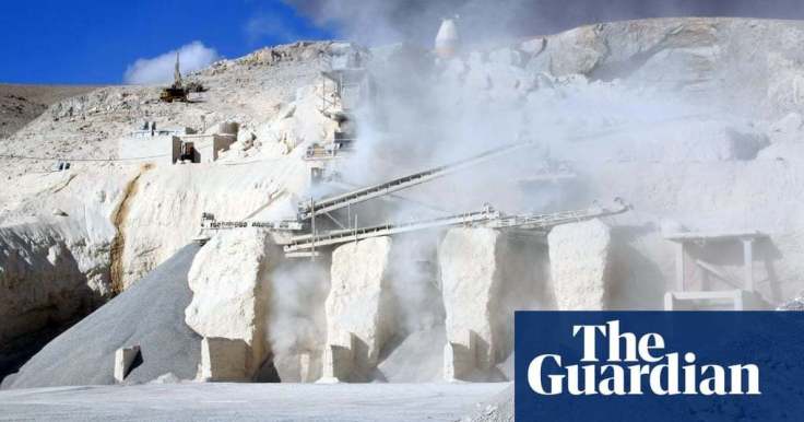
“After water, concrete is the most widely used substance on the planet. But its benefits mask enormous dangers to the planet, to human health – and to culture itself. Our blue and green world is becoming greyer by the second. If the cement industry were a country, it would be the third largest carbon dioxide emitter in the world with up to 2.8bn tonnes.”

GeoEd Tags: industry, sustainability, consumption, climate change, environment, architecture, resources.

Scoop.it Tags: industry, sustainability, consumption, climate change, environment, resources.

Source: www.theguardian.com

OPEC’s Worst Nightmare: Permian Is About to Pump a Lot More

"An infestation of dots, thousands of them, represent oil wells in the Permian basin of West Texas and a slice of New Mexico. In less than a decade, U.S. companies have drilled 114,000. Many of them would turn a profit even with crude prices as low as $30 a barrel. OPEC’s bad dream only deepens next year, when Permian producers expect to iron out distribution snags that will add three pipelines and as much as 2 million barrels of oil a day."

Source: www.bloomberg.com

Overall global commodity prices are impacted by countless local production costs. A large shift in how business is done in one place (in this example, Texas’ Permian Basin) can have reverberating impacts on the local productions of other places that focus on that same global commodity (OPEC).  

GeoEd Tags: energy, resources, economic, political ecology.

Scoop.it Tagsenergy, resources, economic, political ecology.

Identifying Illegal Overfishing

"The vast majority of fishing vessels follow the rules governing fishing – but many are not, and these bad actors can cause a lot of damage. Vessels may take too many fish ­– overfishing – which is causing our fisheries to collapse. Then there is the problem of illegal fishing, which can occur in protected areas, in another country’s waters or on the high seas. This threatens jobs and food security for millions of people, all around the world.

The trouble is, so much of this illegal activity is hidden – it happens out to sea, making it difficult to scrutinize what individual vessels are getting up to. Fortunately, we are now beginning to see what happens after commercial fishing vessels leave port.

The interactive map we created allows anyone in the world with an internet connection to see the activities of the commercial fishing fleet globally."


Scoop.it Tags: water, conservation, biogeography, environmentpollution, resourcesmappingfood production, agriculture.

WordPress TAGS: water, biogeography, environment, pollution, resources, mapping, food production, agriculture.

Source: www.bbc.com

Chile’s Energy Transformation Is Powered by Wind, Sun and Volcanoes

“Once energy dependent, Chile is on track to become a renewables powerhouse with the potential to export electricity. Chile is on track to rely on clean sources for 90 percent of its electricity needs by 2050, up from the current 45 percent.”

Source: www.nytimes.com

The definition of a natural resource changes as the societal and technological context shifts.  Firewood was once the most important energy resource and now there are tree removal companies that haul are paid to haul away what some would consider very valuable goods. The coastal breeze of the Pacific, the harsh sun of the Atacama desert, and the rugged volcanic landscapes of Chile were never an energy resources…until they were made so by technological advancements and shifting economic paradigms.  As this article and embedded video demonstrate, Chile and South America are fully investing in the transition from a fossil fuel-based economy to renewable energy resources.


TagsChileSouth America, industry, sustainabilityeconomic, energy, resources, unit 6 industry.

Borders and the Arctic Ocean

The ice in the Arctic is disappearing. Melting Arctic ice means new economic opportunities: trade routes in the Arctic ocean, and access to natural resources. Because of this, the Arctic nations are now moving to expand their border claims. Russia has shown that it’s the most ambitious, using a potent combination of soft power and military buildup to advance its agenda. They’ve said the Arctic is rightfully theirs.

Source: www.youtube.com

This video is the second video in “Vox borders” series that is shaping up to be an excellent resources for geography educators.  This focus is on Svalbard and Russia’s designs within the Arctic, but this TestTube episode is a shorter version that emphasizes how receding summer ice is being seen as an economic opportunity for all maritime claims in the Arctic.  Canada, the U.S., Russia, and Denmark (Greenland) all are subtly expanding their maritime claims.


Questions to Ponder: How do borders impact the develop/preservation of the Arctic?  How should uninhabited lands and waters be administered politically?


“The Last of the Free Seas”

“The Last of the Free Seas is the title of this fantastic map of the Great Lakes made by Boris Artzbasheff.  It was published in Fortune Magazine in July 1940.”

Source: www.reddit.com

The inland waterways were absolutely critical to the demographic and economic development of the eastern part of the United States, especially from 1820-1940.  Before World War II, Great Lakes shipping exceeded the tonnage of U.S. Pacific Coast shipping (see hi-res map here). World War II and the beginning of the Cold War led to a consolidation of naval power for the United States and its allies, greatly expanding Pacific shipping trade and spurring fast-developing economies countries. 


Great Lakes shipping dramatically declined, in part because steel production has gone to lower-cost producers that were connected to the U.S. economy through the expanded trade.  Some could see irony since the steel warships created from the Great Lakes manufacturing enabled expanded Pacific and Atlantic trade that led to the decline of Great Lakes manufacturing and regional struggles in the rust belt.  Still, more than 200 million tons of cargo, mostly iron ore, coal, and grain, travel across the Great Lakes annually.


This deindustrialization clearly is a huge economic negative but the environmental impacts for lakeside communities has been enormous.  Industrial emissions in the watershed and shipping pollution in the lakes went down as waterfowl populations returned and more waterfront property became swimmable again.  Still this map of the environmental stress on the Great Lakes shows they are far from pristine.    


Tagsenvironment, historicalwater, resources, transportation, industry, economicregions, globalization.


The Fallacy of Endless Economic Growth

What economists around the world get wrong about the future.


The idea that economic growth can continue forever on a finite planet is the unifying faith of industrial civilization. That it is nonsensical in the extreme, a deluded fantasy, doesn’t appear to bother us. We hear the holy truth in the decrees of elected officials, in the laments of economists about flagging GDP, in the authoritative pages of opinion, in the whirligig of advertising, at the World Bank and on Wall Street, in the prospectuses of globe-spanning corporations and in the halls of the smallest small-town chambers of commerce. Growth is sacrosanct. Growth will bring jobs and income, which allow us entry into the state of grace known as affluence, which permits us to consume more, providing more jobs for more people producing more goods and services so that the all-mighty economy can continue to grow. “Growth is our idol, our golden calf,” Herman Daly, an economist known for his anti-growth heresies, told me recently.


Tagsop-ed, economicindustry, sustainability, development, consumption, climate change, environment, resources.


Source: psmag.com

Short Film: How Water Gets From The Nile To Thirsty Refugees

Hundreds of thousands of refugees have fled the civil war in South Sudan and resettled in Uganda. This 12-minute documentary shows the daily struggle to get water.

Source: www.npr.org

Next to nothing in this video will make you happy about the way things operate for refugees in Northern Uganda who have fled from South Sudan.  We all know the about the dire conditions that refugees face, but knowing about the specifics, and hearing stories from the refugees about their lives and living conditions is powerful.  A huge influx of refugees can tax local resources, especially water.  Food can be shipped in, but water a much more locally variable resource.   The UN refugee camps recommend at least 15 liters of water per person be made available each day, but often it is more like 4-8 liters in these camps.  Dedicated wells (or boreholes) are more effective, but costly.  Trucking in water from the Nile River is the preferred method to simply keep these drowning people’s heads above water.    

Questions to Ponder: Consider how much water you drink, use for cooking, bathing, etc. per day in your household.  How difficult would it be to live on 4 liters of water a day?  What about your lifestyle would be changed? 


Tags: Africa, development, Uganda, migrationrefugees, environment, water, sustainability, resources.

Mapping the human impact on the Great Lakes

“It’s no secret that the Great Lakes are suffering tremendous ecological strain — Lake Erie was even pronounced “dead” for a time during the 1960s because of an overload of phosphorus from municipal waste. Back in 1615, though, when the entire region was pristine and explorers Samuel de Champlain and Étienne Brûlé gazed out together from Lake Huron’s shores, they dubbed it la mer douce, ‘the sweet sea.’ Today roughly one-quarter of Canada’s population and a 10th of America’s population drink from the Great Lakes basin; the beleaguered lakes alone hold more than a fifth of Earth’s freshwater.”

Source: www.canadiangeographic.ca

Questions to Ponder: What watershed do you live in?  Where does your drinking water come from?  When you flush the toilet, where does it go? How are places in your watershed linked?  How does this similar map shed more light on these issues?  


TagsCanada, environment, resources, waterspatial, scale

Blog at WordPress.com.

Up ↑