Search

GEOGRAPHY EDUCATION

Supporting geography educators everywhere with current digital resources.

Tag

urban ecology

Site and Situation: New Orleans

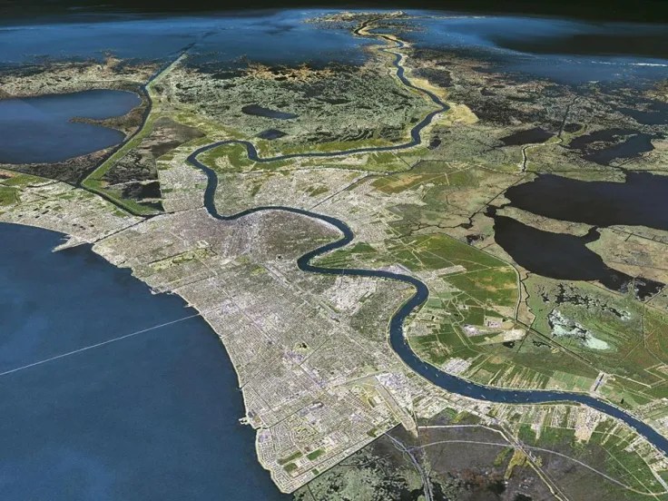
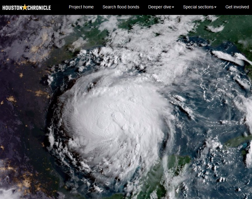
I’d like to interject two geographic terms/concepts not mentioned in the video below about New Orleans: site and situation.  I would argue that in New Orleans has a horrible site (the features of a given location) but a very attractive situation (the connection and relationship to other places and resources).  The first 4.5 minutes of this video nicely highlights the contrast of an incredible situation on a horrible site; this would be a great clip for a general audience (human geography or regional geography).  The remaining portion of the video is still good, but more narrowly focused on the increasingly negative environmental context of New Orleans’ urban ecology.   

Geographers make a distinction between site and situation as they consider the underlying foundation of a place. Few cities represent such a wide chasm between these two aspects as does New Orleans. The situation, or the answer to why does a place exist, was imperative. The Mississippi River was a major artery for the North American continent. As first the Europeans and then the Americans assumed control of the area, a port was essential at the mouth of this river. But the site, the response to where a city is placed, continues to confound. Few environments were or are more inhospitable to human habitation. Poor soil, disease, floods, and hurricanes are constant threats that have plagued the city for over three centuries. But the why trumped the where and hence the paradox of New Orleans persists.

TAGS: Urban ecology, human and environmental modifications.

India’s Surging Pollution Problem

As winter approaches each year, a haze of toxic smog envelopes vast swaths of northern India, including the capital New Delhi, forcing authorities to shut schools and restrict the use of private vehicles. Unlike southern parts of the country, most arid regions of northern India, including New Delhi, struggle with dust, a common air pollutant. Environmental experts say New Delhi’s topography hobbles efforts by authorities to stave off the spike in pollution. In recent years, the problem has been exacerbated by the burning of crop residues in Punjab and Haryana states, part of the farm belt that borders New Delhi. Relatively prosperous farmers from Punjab and Haryana, India’s grain bowl, have started using mechanised harvesters to gather the rice crop, partly to overcome the problem of rising labour costs.” SOURCE: Al Jazeera

Mexico City has a reputation for horrible air pollution–and rightfully so–but Delhi’s air pollution is worse and this year it is off the charts. Much of India faces air pollution problems, but northern India, and especially Delhi sees the convergence of urban, agricultural, demographic, and environmental factors to exacerbate the problems. Geographic problems are often intertwined and is a good issue to use a S.P.E.E.D. or E.S.P.N. activity.

GeoEd Tags: urban, agriculture, population, environment, pollution, South Asia, India.

Indonesia ‘discards’ its capital Jakarta for a new one, but we can’t just dispose of cities

Jakarta1

Indonesia’s government is advancing plans to relocate the country’s capital more than 1,000 kilometres away, from Jakarta on densely populated Java island to Borneo. At a time when modern consumer societies are awash in disposable products, the relocation plan seems to exemplify global society’s tendency to throw things away once they can no longer be used. In other words, Jakarta is a ‘disposable city.’ The situation with Jakarta is only the latest case of a country shifting its capital from an unmanageable urban context.”   Source:  The Conversation

This article, while on the surface is about forward capitals, and Jakarta’s plan to change it’s capital city,  is truly about unsustainable urban land use practices.  Relocating a capital is a part a a fix to alleviate the pressures on the government, but it does not solve the ecological problems of the city itself.  This article is a plea to push for more sustainable urban initiatives.

GeoEd Tags: Indonesia, megacities, urban ecology, SouthEast Asia.


Indonesia chooses a new capital

Capital Indonesia

“Indonesia will build a new capital city on the island of Borneo, home to some of the world’s biggest coal reserves and orangutan habitats, as President Joko Widodo seeks to ease pressure on congested and sinking Jakarta. The relocation of the capital, some 1,400km away from Jakarta, will help spread economic activity outside the nation’s most populous island of Java.”
Jakarta is a megacity that will continue to grow, but it is a sinking city–in fact, the fastest sinking city in the world. The pressures of being the primate city are enormous–the rush hour traffic is considered one of the worst in the world and the continued centralization of government in Jakarta limits economic group in other regions of the country (here is the Guardian’s primer for understanding the situation).  This plan to create a forward capital to encourage growth in Borneo and attempt to limit growth in Jakarta will be fascinating to monitor.  The move to a new capital won’t begin until 2024, and is estimated to cost over $30 billion. For more on forward capitals, here is a BBC article with 5 other examples of countries that have changed their capital cities.  For more on the idea that we just can’t dispose of cities like trash, see this article from The Conversation.

GeoEd Tags: Indonesia, megacities, urban ecology, governance, urban politics, SouthEast Asia.

Jakarta
Jakarta is overcrowded, polluted, and sinking.


Connecticut’s Changing Landscape

“Changing Landscape is a remote sensing-based land cover study that charts landscape changes in Connecticut and portions of New York. It covers the 25-year period from 1985 to 2010 (with in-between dates of 1990, 1995, 2002 and 2006). It includes information on basic land cover, as well as subsidiary analyses of riparian corridor land cover, impervious cover and agricultural field and soil analysis.”

Source: clear3.uconn.edu

This story map, created with the Story Map Journal application in ArcGIS Online, is a great example of how to use the “Story Action” features.  Story Action features can move the map view to a particular location or change what is being displayed on the main stage of the story map.  These can also be used to navigate to a different section of the a story map.

Here are two excellent Story Maps that use “Story Action” features.  Please take some time to explore both of them and note how these features enhance the presentation of this spatial information:

  1. Connecticut’s Changing Landscape
  2. Damaged and Defiant: Houston Stories
  3. And just for fun, the Cross-Section of elevation along the meridians.

GeoEd TAGS: urban ecology, mapping, esri, storymap.

Damaged and defiant: Hurricane Harvey

Houston holds strong in the wake of devastation left by Hurricane Harvey.

Source: www.houstonchronicle.com

I am sharing these three interactive webmaps of Houston with my mapping courses to demonstrate what is technologically possible.  Texts, charts, pictures, videos, and maps can be seamlessly integrated to present spatial information in an incredibly engaging and accessible manner.  

Houston’s Hurricane Harvey was incredibly impactful but the factors leading to this were also very complex.  These three Story maps lay out:

  1. Houston’s urban ecological context
  2. The geographic origins of Hurricane Harvey
  3. The human stories from Hurricane Harvey


Scoop.it Tags:  physical, water, coastal, urban,  urban ecology, disasters, mapping, ESRI, StoryMap.

WordPress TAGS: physical, water, coastal, urban, urban ecology, disasters, mapping, esri, storymap.

South Africa Is Still Under Apartheid

“More than two decades after the end of apartheid in South Africa, Cape Town remains racially segregated, with many black residents living in substandard townships.”

Source: www.youtube.com

The title is a bit inflammatory–news agencies may pretend that they aren’t in the shock-and-awe, clickbait economy, but they invented the salacious headline to grab our attention.  Still, the racial inequities of a system as pervasive as apartheid aren’t going to be reversed in a generation and the racial differences in Capetown are coming under more international scrutiny as the they are in the midst of their current drought.


Tags: South Africa, Africarace, ethnicityneighborhood, urban, planning, drought, water, urban ecology.   

Houston’s stories of Hurricane Harvey

“Blue and her team selected 45 stories, each plotted with ESRI’s ArcGIS software on a map of Greater Houston and tied to the exact location where it was first told. The resulting story map of Hurricane Harvey, ‘Damaged and Defiant: Houston Stories,’ was published in the Houston Chronicle in December. The map shows short narratives gathered by Chronicle staffers from people across the area — from Crosby to Kingwood to Katy — each a unique perspective on the storm; told together, they’re the collective account of a city that experienced one of the worst natural disasters in U.S. history.”

Source: news.rice.edu

These interlinked Houston story maps show some of the key elements of a good story map: 1) strong spatial analytical components, 2) a powerful narrative, 3) rich visuals, 4) solid cartography, and 5) well-sourced information.


Tags: fluvialwatercoastal, urban, disasters, physical, mappingESRIStoryMap.

Mapping Coastal Flood Risk Lags Behind Sea Level Rise

Federal maps help determine who on the coast must buy flood insurance, but many don’t include the latest data. Maryland is now making its own flood maps, so homeowners can see if they’re at risk.

Source: www.npr.org

Geographic themes are overflowing (it was an unintended pun, but I’ll just let that wash over you) in this podcast.  I suggest playing a game early in the year/semester called “find the geography.”  What geographic theme/content areas will your students find in this podcast? 


Tagspodcast, mapping, cartography, climate change, environment, watercoastal,  urban, planningurban ecology.

Create a free website or blog at WordPress.com.

Up ↑