Search

GEOGRAPHY EDUCATION

Supporting geography educators everywhere with current digital resources.

Tag

map

How to Read a Topo Map

topographic_map_grande

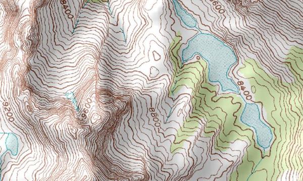
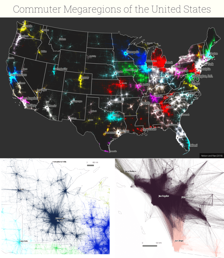
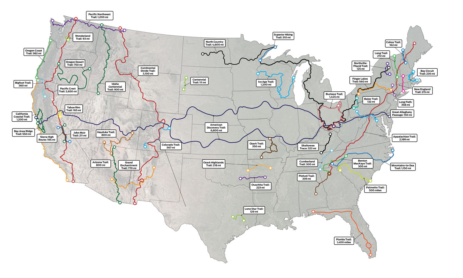
“A topographic map is designed to show the physical features and terrain of an area. They’re different from other maps because they show the three-dimensional landscape: its contours, elevations, topographic features, bodies of water, and vegetation.” SOURCE: Backpacker.com

This article gives a nice introduction to topographic maps, explains how to read them, and why they are useful.  While I love digital maps and the features that are offered through GIS, old school paper maps still play a vital role in helping us navigate this world of ours.  This additional article from CityLab, shows how you can lie with maps (and it’s not just with a sharpie).

Tags: mapping, physical, cartography, unit 1 geoprinciples.

The Age of Borders

The creation date of (almost) every international border.  Full-size image here.


Tags: infographic, worldwide, borders, political, historical.

Source: c1.staticflickr.com

GeoSettr

In May 2013, GeoGuessr came online and quickly became a favorite quiz game of geo-enthusiasts.  Using 5 random locations in Google Street View.  The game player can search the area in Street View and then make a guess as to where it is on the map.  Using GeoSettr, you can create your own GeoGuessr challenge by choosing five locations on Google Street View.

Source: geosettr.ml

You can customize your own GeoGuessr quizzes now, as others pan and zoom in the StreetView to explore the landscape you selected and find more context clues as to where that location is.  Try my sample quiz that I made based on these 5 clues.   

  1. The best place to get clam cakes and doughboys in RI
  2. My hometown is home to this center of athletic excellence
  3. This monument was a part of my research in this Latin American city
  4. This is where I went to school to get my Ph.D.
  5. Home to the movie “Close Encounters,” this National Monument has always fascinated me.  

Tags: landscape, place, trivia.

America’s Best Long Trails

Plan your next big hike with this map of America’s most-loved long trails.

Source: www.backpacker.com

My uncle hiked the entire Pacific Crest Trail and as a kid the enormity of that feat was both inspirational and mind-boggling.  Recently I watched an incredible documentary about an ultra-marathoner’s quest on Vermont’s Long Trail (Finding Traction: free on Amazon Prime–trailer here).  While I doubt most of us could go the full length of these trails given our jobs, fitness levels, etc., I do think that getting outside to explore some of the physical environments in our local areas this summer sounds like a fantastic idea (high-res map here).  


Tags: transportation, landscape, place, sportphysical, environment, mappingmap.

Growth of Colonial Settlement

European settlement began in the region around Chesapeake Bay and in the Northeast, then spread south and west into the Appalachian Mountains.


Questions to Ponder: How did European immigrants settle along the East Coast? How did geography determine settlement patterns? 


Tagsmigrationmap, historicalcolonialism, USA, National Geographic.

Source: www.nationalgeographic.org

50% of the Canadian population lives in these counties

“I was inspired by 50% of the U.S. lives in these counties. map. I was wondering what the equivalent map for Canada would look like. I couldn’t find one, so I created my own.”

Source: www.reddit.com

During the U.S. presidential election much was made about the differences between rural and urban regions of the United States.  Clearly the United States isn’t the only North American country that has a highly clustered population distribution. 


Question to Ponder: How does this basic demographic reality impact Canadian politics, policies, infrastucture, culture, etc.?


TagsCanadamap, North America, population, density.

CIA’s Cartography Division Shares Declassified Maps

“As much as James Bond is defined by his outlandish gadgets, one of the most important tools for real-life spies is actually much less flashy: maps. Whether used to gather information or plan an attack, good maps are an integral part of the tradecraft of espionage. Now, to celebrate 75 years of serious cartography, the Central Intelligence Agency has declassified and put decades of once-secret maps online.  These days, the C.I.A. and other intelligence agencies rely more on digital mapping technologies and satellite images to make its maps, but for decades it relied on geographers and cartographers for planning and executing operations around the world. Because these maps could literally mean the difference between life and death for spies and soldiers alike, making them as accurate as possible was paramount, Greg Miller reports for National Geographic.”


Tags: mapping, geopolitics, maphistorical, map archives

Source: www.smithsonianmag.com

Every Name Is a Music Reference

The designers behind the “Alternative Love Blueprint” are back with a map of the world. Only this map uses song titles instead of place names.

Source: www.wired.com

As one friend said, I think we can forgive the poor projection choice because of the incredibly clever naming scheme of this map.  Very fun idea, and worth exploring. 


Tags: music, map.

America’s ‘Megaregions’ using Commuter Data

New maps use math to define the amorphous term.

Source: www.citylab.com

By now I’m sure many of you have seen some iteration of this research and data visualization circulating through social media outlets (you can see the article from City Lab, Atlas Obscura or an urban planning program).  We use terms like the greater metropolitan area to express the idea that areas beyond the city boundaries and even beyond the metropolitan statistical areas are linked with cities.  These ‘mega-regions’ are in part the hinterlands of a city, a functional region where the cities act as hubs of economic regions.   

Tags: regions, urban, transportationeconomicvisualization, mapping, USA, planning.

Blog at WordPress.com.

Up ↑