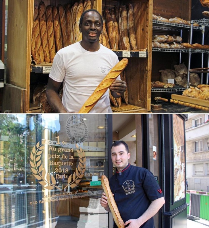
Search

GEOGRAPHY EDUCATION

Supporting geography educators everywhere with current digital resources.

Tag

technology

The Perfect French Baguette

Baguette2

While there are few symbols as quintessentially French as the baguette, its status – and quality – have been uncertain in recent years. Beginning in the 1950s, bakers began looking for shortcuts to make baguettes more quickly: relying on frozen, pre-made dough. ‘Those bakers at that time were happy,’ said Bouattour, as he led me past the fresh loaves at his Arlette & Colette in Paris’ 17th arrondissement. ‘But it killed our profession.’ In an attempt to save traditional French baguettes from widespread industrialisation, France passed Le Décret Pain (‘The Bread Decree’) in 1993, establishing that, by law, an authentic baguette de tradition must be made by hand, sold in the same place it’s baked and only made with water, wheat flour, yeast and salt.”  Source: BBC

Technological advancements and economic practices would have altered French baking practices, but to halt the change cultural purists took political steps to preserve the old cultural traditions.  The running of bakeries, and the winners of the prize for the best Parisian baguette have been bakers who come from immigrant families. Bakers with Middle Eastern, North African, and West African backgrounds are now key participants of shaping the most French of cultural goods.

Questions to Ponder: Why have bread-making practices become politicized in Paris?  How have immigrants changed French cultural practices?  How have French cultural practices changed immigrants?

GeoEd Tags: culture, food production, France, food, technology, migration, diffusion.

Leading the Location Intelligence Revolution

"As GPS devises, sensors, and drones proliferate, the power of location intelligence increases exponentially. This means LI can bring clarity to the most pressing business challenges – even those that at first glance don’t seem location related. Esri has location down to a science – The Science of Where. Examples from the Bavarian Police Department, Switzerland’s largest retailer, Migros, the Port of Rotterdam, and the European Environment Agency, provide just a taste of the broad scope of challenges that can be tackled through the lens of where."

Source: www.youtube.com

This video is a good demonstration of the value of GIS, geospatial technologies, and locational intelligence. 

GeoEd Tags: GIS, esri, video, mapping, cartography, geospatial, technology.

Scoop.it Tags: GIS, ESRI, video, mapping, cartography, geospatial, technology.

Mapping Apps May Make Traffic Worse

Apps like Waze, Google Maps, and Apple Maps may make traffic conditions worse in some areas, new research suggests.


In the pre-mobile-app days, drivers’ selfishness was limited by their knowledge of the road network. In those conditions, both simulation and real-world experience showed that most people stuck to the freeways and arterial roads. When there are more app-using drivers, congestion builds up at off-ramps, creating more traffic on the freeway. While it’s clear that traffic on local roads gets worse with the use of these apps, Bayen said that nobody has managed to do a multi-scale analysis that can determine if the apps, even if they create local problems, are better or worse for whole traffic basins.


Tags: urbantechnology, transportation.

Source: www.theatlantic.com

How to Defeat Drought

Cape Town is running out of water. Israel offers some lessons on how to avoid that fate.

Source: foreignpolicy.com

Most droughts are caused by a combination of human and physical geographic factors. Cape Town is current in the midst of a 3 year long drought that is causing many officials to consider drastic measures such as cutting off all private water taps and rationing out 13 gallons per resident per day.  


I would like for us to also consider cases beyond South Africa, and think about the the broader issues of resource management, urbanization, resilience, and changing climatic conditions.  Resources Watch discusses critical water shortages in Morocco, India, Iraq and Spain with excellent maps, charts, and graphs. This article from Foreign Policy demonstrates how Israel has worked to maximize their minimal water resources (recycling grey water for agriculture and desalinization). The World Resources Institute discusses 3 things cities can glean from the South African crisis (1. Understand risks, 2. Manage the water budget, and 3. Invest in resilience).  


Tags: drought, water, environment, technologyenvironment modify, South AfricaIsrael, Spain, MoroccoIndiaIraq.

Why Don’t We All Speak the Same Language?

There are 7,000 languages spoken on Earth. What are the costs — and benefits — of our modern-day Tower of Babel?

Source: freakonomics.com

These two podcasts are great mainstream looks at issues that filled with cultural geography content.  So many languages on Earth is clearly inefficient (the EU spends $1 billion per year on translation), and yet, linguistic diversity is such a rich part of humanity’s cultural heritage.  Listen to the first episode, Why Don’t We All Speak the Same Language? as well as the follow-up episode, What Would Be the Best Universal Language?


Tags: languagecultureworldwide, English, regions, diffusiontechnology.

Pro Wrestling and Economic Restructuring

“For decades, professional wrestling in North America operated under a system of informally defined ‘territories.’ Each territory represented an individual promotion with its own stable of talent that drew crowds to local arenas and broadcast the product on regional television stations. In 1982, Vince McMahon purchased his father’s company, the World Wrestling Federation. For almost two decades, he endured an epic conquest of the pro wrestling world that led to where he is today: standing tall as the undisputed king of the industry.”

Source: www.youtube.com

This may seem like a strange video for geography educators and students.  In one sense, the history of a wrestling entertainment business is trivial, but this provides a great example of how using economies of scale can overcome regional advantages as new technologies enter the market.  Maybe is not a ‘real’ sport, but the example of wrestling might pique a few students’ interest as the economic principles are made manifest. 


Questions to Ponder: How do emerging technologies lead to economic disruption?  Why was regional systems so prevalent in the 1950s and1960s?  If Vince McMahon didn’t pursue this plan, would there still be smaller, regional wrestling organizations?  Why or why not? 


Tags: regions, economic, diffusiontechnologysport, industry

As Climate Change Accelerates, Floating Cities Look Like Less of a Pipe Dream

A costly plan to build floating islands shows how climate change is pushing the search for innovative solutions, but some critics ask who will ultimately benefit.

Source: www.nytimes.com

As coastal communities are considering what the tangible impacts of climate change might be, things that were once considered science fiction could be a part of how people adapt to the modifications we’ve collectively made to our global environment that we depend on to sustain life.  


Tags: physicaltechnologysustainability, climate change, environment, resources, watercoastal, environment dependenvironment adapt, environment modify.

Israel Proves the Desalination Era Is Here

One of the driest countries on Earth now makes more freshwater than it needs


Driven by necessity, Israel is learning to squeeze more out of a drop of water than any country on Earth; researchers have pioneered new techniques in drip irrigation, water treatment and desalination. “The Middle East is drying up,” says Osnat Gillor, a professor at the Zuckerberg Institute who studies the use of recycled wastewater on crops. “The only country that isn’t suffering acute water stress is Israel.” That water stress has been a major factor in the turmoil tearing apart the Middle East, but Bar-Zeev believes that Israel’s solutions can help its parched neighbors, too — and in the process, bring together old enemies in common cause.


Tags: drought, water, environment, Israeltechnology, Middle East.

Source: www.scientificamerican.com

How the U.S. Air Force Mapped the World at the Dawn of the Cold War

One specialized unit gathered data that could guide a missile to a target thousands of miles away.


The work of the 1370th bridged a crucial gap in the history of military technology. By the late 1950s, both the United States and the Soviet Union had developed intercontinental ballistic missiles, but satellite navigation systems like GPS weren’t yet up and running. That left military planners with a huge challenge: how to program a missile to hit a target on the other side of the world. Even a tiny mistake could be disastrous.


Tags: mapping, cartography, technology, historical.

Source: news.nationalgeographic.com

Create a free website or blog at WordPress.com.

Up ↑