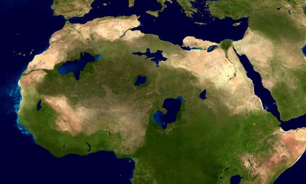
I’m deeply fascinated by the Sahara, but since most of my focus in academic geography is on human geography and the settled portions of the planet, this often goes unaddressed even though it explains much about the world we live in. The main landforms of the desert are dunes (ergs), desert pavement (regs), and mountains that rise above the windswept features of ergs and regs. As it’s so inhospitable, it’s hard to imagine that is was that prior to 5,000 years ago the Sahara was more like a savanna with more life (Axial tilt shifts, and other climatic factors shaped this).
Prior to the Sahara as we know it today, the area occupied by dunes now is often in old lake beds because sand (like water) settles into basins. The mountains today bear witness of larger human settlements with art like cave drawings preserved in the high mountain plateaus. The largest lake today, Lake Chad, is a small remnant of what once was, now called Lake Mega Chad…no, I’m not kidding. Like the Great Salt Lake is a remnant of a much larger Lake Bonneville, and still prone to changes, Lake Chad has continued to dry up, losing over 90% of it’s surface area since the 1950.
An artistic rendition of a greener North Africa over 5,000 years ago with more lakes. SOURCE: Countere Magazine
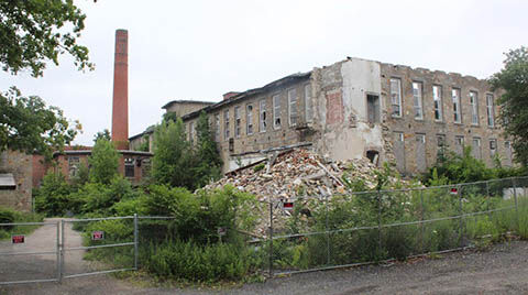
“The historic Hope Mill in Scituate will soon be torn down after it was deemed unsafe. The long-vacant mill, which officially shut down in 2006, and has been slowly decaying ever since. The former textile mill sits along the Pawtuxet River in the Hope Village Historic District, which is listed on the National Register of Historic Places.” SOURCE: WPRI
This story about this old mill being demolished (which is less than 2 miles from my residence) definitely hits close to home.
Growth and development are signs in the cultural landscape that show change in the economic landscape. So too are decline and decay. Mills used to dot the large, navigable rivers of southern New England, helping to shape a distinctive feature of Rhode Island landscapes. As energy technology and local economics shifted, these mills no longer are used to serve their original purpose to manufacture light textiles. Today many have been retrofitted to be condominiums, apartments, warehouses, retails space and all kinds of other land uses. Even with this creative use of existing infrastructure, many mills are underutilized or even become abandoned. After years of neglect, these types of building have a negative impact on the community as visible signs of disuse create a depressing ambience that signals communal decline.
The mystery on the ‘sailing stones’ in Death Valley’s Racetrack playa has been solved and I wrote about a few years ago when it happened, but the video embedded above is so well done, it’s worth revisiting this remote, harsh landscape where large rocks can ‘flow’ uphill.
SPOILERS (since 2014): On very rare occasions, when it rains in the region, water will accumulate in the playa (discovermagazine.com), and if the temperature dips below freezing a thin layer of ice will cover the playa. If the wind is powerful and consistent enough, the wind will push the panels of ice against these rocks and over time, the ice floes will push these rocks, leaving behind distinctive trails (latimes.com). This perfect combination of water, wind, ice and heat creates a remarkable signature on the landscape (livescience.com). The decidedly non-aerodynamic rocks of Death Valley’s Racetrack Playa leave behind a trail in the hot desert. Numerous attempts using GPS receivers (NatGeo.com) and good ol’ fashioned observations have been made, but observing ice in Death Valley is so rare that it was never observed until 2014 (phys.org).
While I try to keep things nonpartisan, sometimes objective truths become partisan issues, and often the study of human geography can improve our collective political dialog. Department of Transportation, Pete Buttigieg (a.k.a. Mayor Pete) said “there is racism physically built into some of our highways.” Online detractors noted that rebar, concrete, and asphalt can’t be racist, etc. You see the over-literal interpretation, but I want to discuss his bigger point—how has racism shaped the building of infrastructure and urban landscapes?
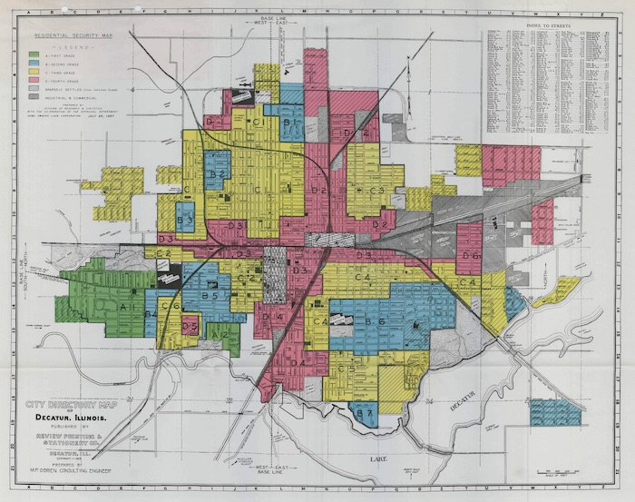
The term redlining has a specific definition and a broader application. First, the narrower definition; redlining was a historical practice in the early to mid-20th century where banks and other decision-makers used city maps that marked low-income neighborhoods (pre-dominantly African American), and would deny potential home-owners’ loans to purchase in these neighborhoods. In an era of legalized segregation, African Americans were in a bind; they could not move into the white neighborhoods, but they could not get loans to purchase a home in their own neighborhood. The maps literally used a red line to mark the neighborhoods where the banks would not provide any home-lending services to the residents. Explore this fantastic interactive map, Mapping Inequality: Redlining in New Deal America. You can use this to find redlining close to your home, or the city where I teach, Providence, RI.
1929 Home Owners Loan Corporation Map of Decatur, IL.
More broadly speaking, redlining is not just about the denial of home loans. Many practices such as this meant African Americans in the United States could not get access to the full range of services, utilities, resources, and planning to see improvements in their neighborhoods.
The era of redlining also coincided with the era of the private automobile and the beginning of large freeways on the American landscape. The major freeways in urban centers weren’t placed on conveniently open spaces, but by tearing down (typically) poor neighborhoods that had less of a political voice. This happened in African American neighborhoods in Baltimore, Oakland, New York, Detroit, Cincinnati…the list is far too long. Read this piece in the Guardian for some images and examples.
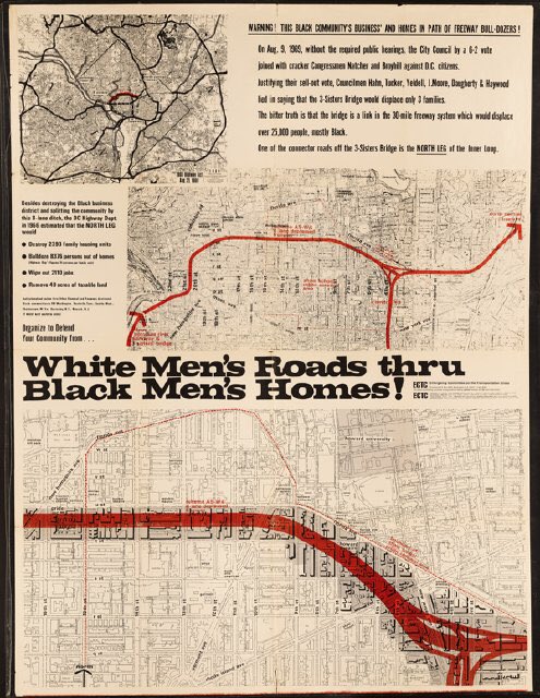
A poster against the creation of proposed highway in Washington DC. Source: DC History
So, when Mayor Pete says that “there is racism physically built into some of our highways,” he means it, and it’s a part of our historical geography. The road itself might not be racist, but the institutions that plowed through poor Black neighborhoods is, and leaves a legacy on the built environment. Redlining is obviously illegal today, but the neighborhoods they shaped, divided by railroad tracks or highways or both, these communities are still impacted by the policies of yesteryear.
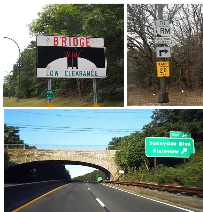
For generations, New York City urbanists have adored Jane Jacobs as the champion for local communities and her opposition to the soulless, neighborhood-destroying urban planner, Robert Moses. This is partially true, if simplistic, because hating one individual (Robert Moses) for inserting oppressive elements into the landscape misses the bigger point that he was simply in charge of the system, and if it weren’t for him, there would have been another to take his place. Let’s use one famous NYC, Robert Moses example of racism in the built landscape:
Images from Long Island, showing bridge overpasses that limit public transportation to beaches.
Action: Robert Moses designed Long Island bridges and highways with low overpasses.
Result: Long Island beaches are inaccessible through mass transit.
Purpose: Limit access of NYC poor from the affluent beaches of Long Island.
What are the implications of these facts? One instance of this type of infrastructural planning might be a coincidence rather than a sign of racial bias, or class-based bias, but the preponderance of evidence across the country from this era leads to the obvious conclusion that U.S. infrastructure, especially the highways, were shaped by racist policies that continue to have racial impacts. The evidence is there; for any honest observer, the conclusion that racism shaped U.S. infrastructure is not controversial.
Examine examples in your own community to see how these practices have shaped your local neighborhoods. Once you’ve seen how your community has been shaped, look at at other examples across the U.S. to see that your neighborhood is a part of a broader spatial pattern that shows how racism has shaped U.S. infrastructure.
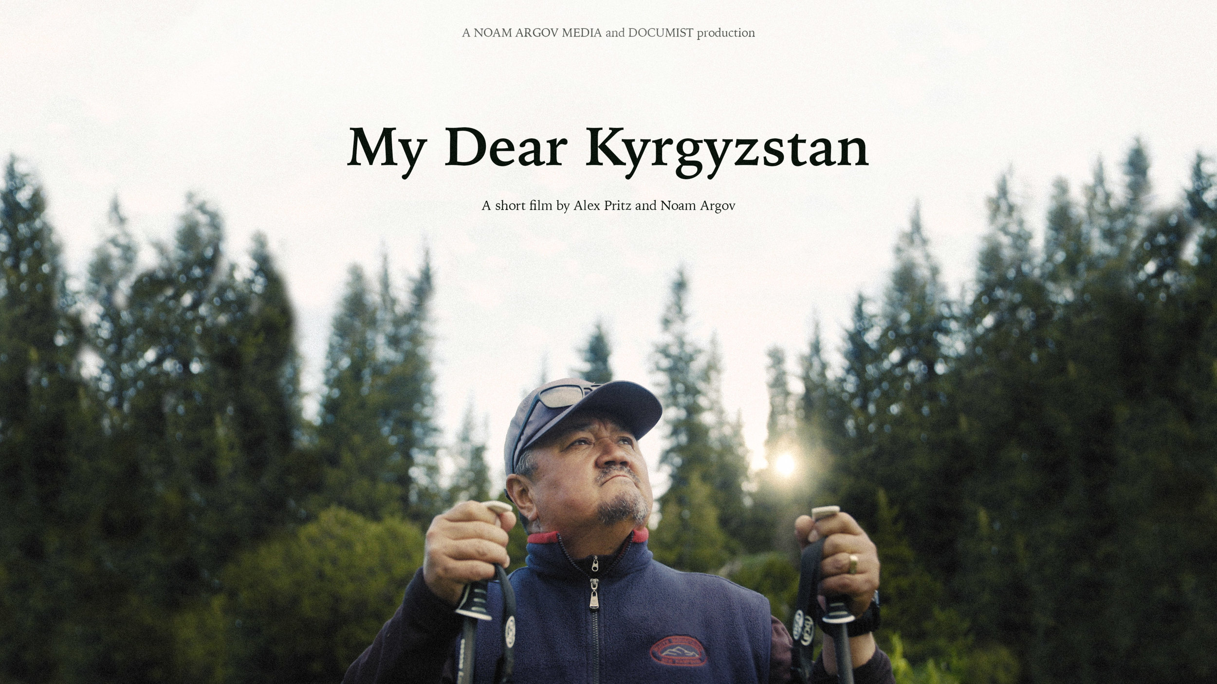
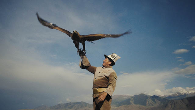
“Emil is a social media-obsessed entrepreneur in one of the most remote places on earth: An abandoned Soviet mining village in Kyrgyzstan. Emil has returned to put his village on the map as an international tourist destination.” SOURCE: MailChimp
This delightful video shows the former Soviet mining town of Jyrgalan and a local entrepreneur that wants to revitalize the village economy, bring in the outside world, and make is home a tourist destination. It serves several purposes for a geography teacher. One, it’s a great portal into a Central Asian country where most of my students don’t have any real reference points. Two, the video highlights important geographic concepts such as tourism’s impact on indigenous cultures and globalization’s impact on previously isolated locations. Three, this is a great case study for a cultural landscape analysis. The video has some incredible juxtapositions; nomads wearing traditional clothes encountering adventure tourists outfitted in Patagonia gear, people in town cutting grass with scythes as well as gas lawn mowers, and traditional architectural styles intermixed with signs of modernity such as satellite antennas. The physical and cultural landscapes in this are absolutely stunning and worth the twelve minutes of your time.
“A generation ago, long before Modi (and the BJP) was in power, right-wing Hindu nationalist leaders in Maharashtra state renamed Bombay as Mumbai — a nod to the city’s patron goddess Mumbadevi. Other cities followed: Madras became Chennai; Calcutta, Kolkata; Bangalore, Bengaluru. All the changes were a rejection of Anglicized names that came into use during British colonial rule. In the most recent wave of name changes, it’s not about erasing colonial monikers. It’s about erasing Muslim ones.”
Indian officials have been altering toponyms to be more Hinducentric; this is a results of growing Hindu nationalism as an important element of modern Indian politics. In another thematically similar, but regionally distinct example, we can see how place names matter in American cities. When large corporations (like Google or Amazon) move in to a city, the corporations might try to rename the neighborhoods and, in a sense, rebrand the place.
Both examples show that the cultural landscape, including the names on them, are not just a passive reflection of the cultures that have shaped these places; they manifest the power dynamics of competing cultural groups seeking to assert their vision of place and culture to be physically manifested in public spaces.
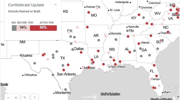
The maps (and the charts) created from this national database is quite revealing. At least 36 ‘Confederate-themed’ schools have changed their names since 2015 and I suspect that number will continue to grow in the coming years.
“The modern built environment in the United States is now totally dependent on air conditioning. A lot of our buildings would be uninhabitable in the summer without AC, and all of the electricity needed to keep it running.”
Like so many 99 percent invisible podcasts, this blends urban design, social geography, local history in a way that deepens our understanding of place. Air conditioning has powerfully reshaped so many geographic patterns that many of ways. Some mentioned in this podcast include: a) the rapid expansion of the Sun Belt, b) less climatically and regionally distinctive architecture can now be found in the cultural landscape, and c) an enormous amount of energy is consumed to maintain our hyper-cooled buildings (the U.S. now uses as much electricity for air conditioning as it did for all purposes in 1955).
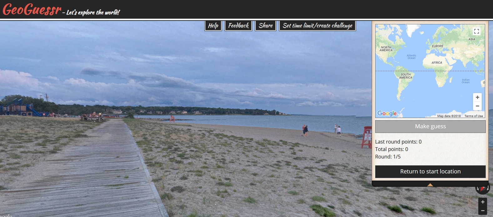
In May 2013, GeoGuessr came online and quickly became a favorite quiz game of geo-enthusiasts. Using 5 random locations in Google Street View. The game player can search the area in Street View and then make a guess as to where it is on the map. Using GeoSettr, you can create your own GeoGuessr challenge by choosing five locations on Google Street View.
You can customize your own GeoGuessr quizzes now, as others pan and zoom in the StreetView to explore the landscape you selected and find more context clues as to where that location is. Try my sample quiz that I made based on these 5 clues.
The best place to get clam cakes and doughboys in RI
My hometown is home to this center of athletic excellence
This monument was a part of my research in this Latin American city
This is where I went to school to get my Ph.D.
Home to the movie “Close Encounters,” this National Monument has always fascinated me.