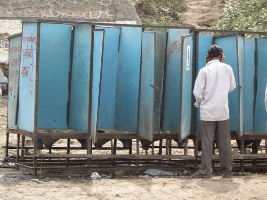
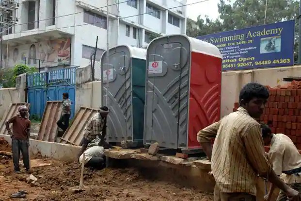
I’ve been teaching about the lack of toilets, open defecation, and adequate sanitation in India for years now, but over the pandemic, some of those articles I referenced became outdated (2016). So today I wanted to refresh my teaching materials. While the statistics have improved, it is still a serious health issue that remains a major impediment to economic and social development. The government proudly states that 100% of Indians have access to toilets, but a national survey found that 10% of the rural areas still defecate in the open (with other estimates much worse). Below are some good articles to get a sense of the current situation.
“The wonders of modern medicine and nutrition make it easy to believe we enjoy longer lives than at any time in human history, but we may not be that special after all.” SOURCE: BBC
This BBC article explores many of our assumptions about demographic issues before statistics were recorded. This article especially looks at the notion that our life span has been increasing throughout history. This would be a good article to get some background information about stage 1 of the demographic transition. In a nutshell, the article’s premise is that just because life expectancy is increasing, it does not mean that our lifespan is the main reason. The main reason life expectancy has improved is that more children are surviving their early years not because we have extended the lifespan of elderly so much.
There are far too many geographic issues that stem out of the Coronavirus pandemic to create anything close to comprehensive, but I wanted to share some of the articles that caught my eye recently because they touch on particularly geographic themes. So, this will not give a global overview, predictions, or breaking news, but some of the underlying issues and questions that we are now grappling with as so many are now in some form of self-isolation.
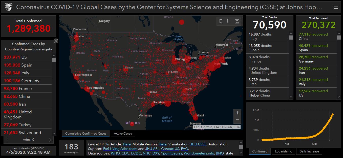
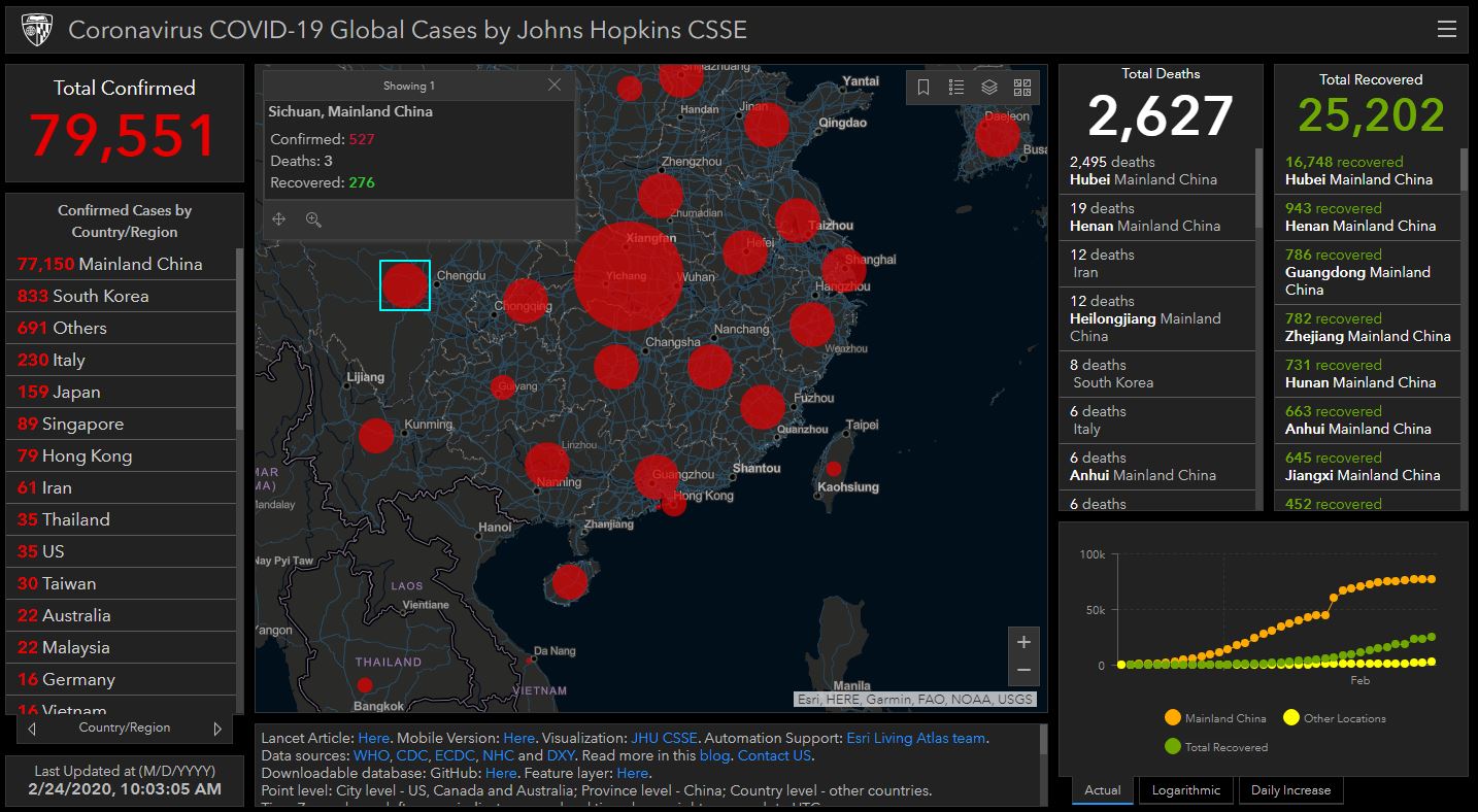
MAPPING: The best, introductory-level walk-through of how to map the Coronavirus uses ArcGIS online, and has interactive layers that are updated daily, so you don’t have to recreate the wheel for every time new data gets released. If students are familiar with ArcGIS and already have an account, this is worth having them explore it to learn cartographic techniques.
ENVIRONMENT: There are a host of unintended consequences in natural systems, and when one part of the system, gets altered, there are some down-stream impacts. This article in the Atlantic discusses some of the environmental impacts of the mass shutdown of normal human activities (1-less pollution, 2-less seismic activity, 3-quiter urban environments).
DEVELOPMENT: The impacts of COVID-19 are clearly uneven; countries and cities that are the most globally connected might benefit usually economically from these connections, but are facing one of the times that this connectivity is a threat to the community. India, by and large through March 2020, managed to avoid making global headlines, but as the world’s second largest population with some incredibly dense megacities, many are asking how the Coronavirus will impact India in the coming weeks.
URBANIZATION: In the United States, the densest counties have been the most impacted by COVID-19 while rural areas have need been as heavily impacted (by and large—rural counties with ski resorts are one prominent exception to this generalization). Some are discussing urban density in the time of a pandemic, and there are calls to rethink densely populated cities. This article from CityLab also discusses the density as a key issue in the transmission of disease, but it is quick to point out other factors that lead some hyper-dense cities to effectively control the spread as well.
CULTURE: To wear a mask, or to not wear a mask? Why is this a question that seems so controversial? As more time goes by, we see that wearing a mask to prevent the spread of a disease is not just a medical issue, but also a cultural issue. Some cultures are uncomfortable with the idea of covering part of face in public and some react against the concept because of the cultural connotations that go along with mask-wearing. Other societies see if as a prudent way to do your civic duty. Many are reconsidering their cultural norms that they associate with masks as COVID-19 continues to expand into more communities.
DIFFUSION: This video centers on the beginnings of the spread of the Coronavirus and the origins in Wuhan. I’m very sensitive to the fact that many discussions about its origin in China can quickly go down some racist paths. This Vox video explains the wet markets of China as a likely source of infectious disease without veering into racist assumptions. This interactive from the NY Times explains how the disease spread beyond China.
Stay healthy, stay safe. I miss other humans, and being social. I think everyone wishes things were different, but geography and spatial analysis is one of the key lenses that we need to come out on the other end of this. I hope that we can come out of this more united as members of the human race with a greater resolve to work together to solve global issues.
“We are tracking the COVID-19 spread in real-time on our interactive dashboard with data available for download. We are also modeling the spread of the virus.” SOURCE: GIS and DATA at Johns Hopkins University
The video below covers 3 major economic impacts that the virus will have on the global economy. In short, 1-Tourism and Travel, 2-Supply Chains, and 3-Flight to Quality Goods.
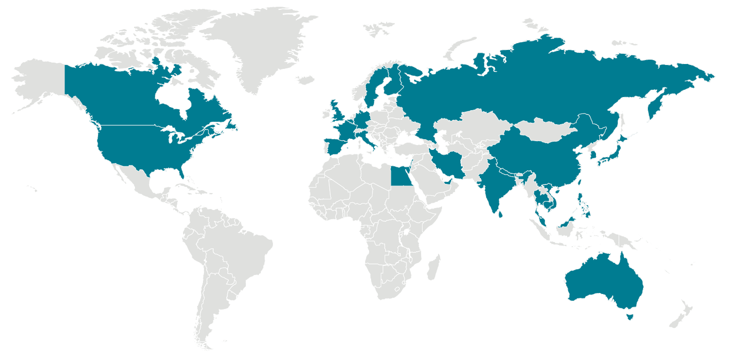
This data offers excellent insight into regional developmental patterns around the world–it is very much worth exploring. However I’m sharing this also for it’s mapping project potential; the data behind this map is available in the article and students can make their own maps with it.
“Obesity is a global problem, but more people are getting fatter in developing countries than anywhere else. If current trends continue, obese children will soon outnumber those who are undernourished. Nearly half of the world’s overweight and obese children under five years old, live in Asia. And in Africa, the number of overweight children under five has increased by nearly 50% since 2000. Hunger still blights many parts of the world. But the share of people who do not have enough to eat is in decline. Globally one in nine people in the world suffer from chronic undernourishment. One in ten are obese. If current trends continue, the share of obese children in the world will surpass the number of undernourished by 2022. Africa has the fastest-growing middle class in the world. A move from traditional foods to high-calorie fast food and a more sedentary lifestyle is driving the rise in obesity. Health systems in Africa, more focused on treating malnourishment and diseases like malaria and HIV, are ill equipped to deal with obesity-related illnesses like heart disease and diabetes. “
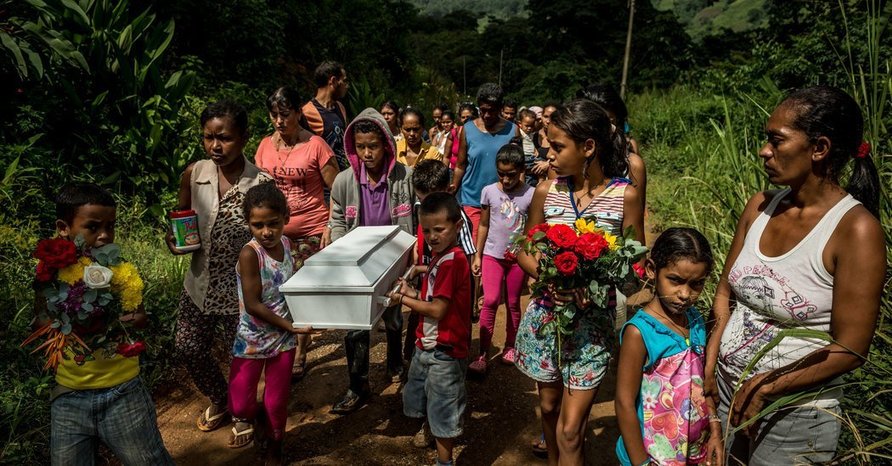
“Venezuela has the largest proven oil reserves in the world. But in the last three years its economy has collapsed. Hunger has gripped the nation for years. Now, it’s killing children. The Venezuelan government knows, but won’t admit it. Doctors are seeing record numbers of children with severe malnutrition. Before Venezuela’s economy started spiraling, doctors say, almost all of the child malnutrition cases they saw in public hospitals stemmed from neglect or abuse by parents. But as the economic crisis began to intensify in 2015 and 2016, the number of cases of severe malnutrition at the nation’s leading pediatric health center in the capital more than tripled, doctors say. 2017 was even worse.”
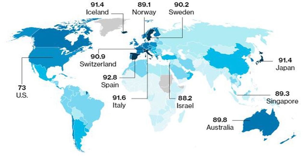
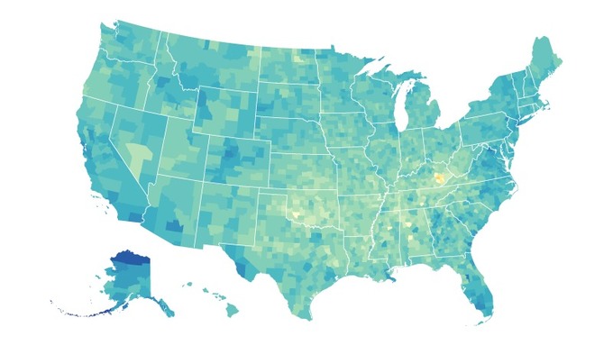
“The wealthiest country, which spends the most money on care for the sick, has far from the best health outcomes. Babies born in eastern Kentucky, along the Mississippi Delta and on Native American reservations in the Dakotas have the lowest life expectancies in the country. If current health trends continue, they aren’t expected to live much beyond an average of 70 years. Meanwhile, a baby born along the wealthy coast of California can be expected to live as long as 85 years, the authors found.“
Questions to Ponder: What geographic and socioeconomic factors shape mortality rates? What is better about society today then before? Has anything worsened? How come?
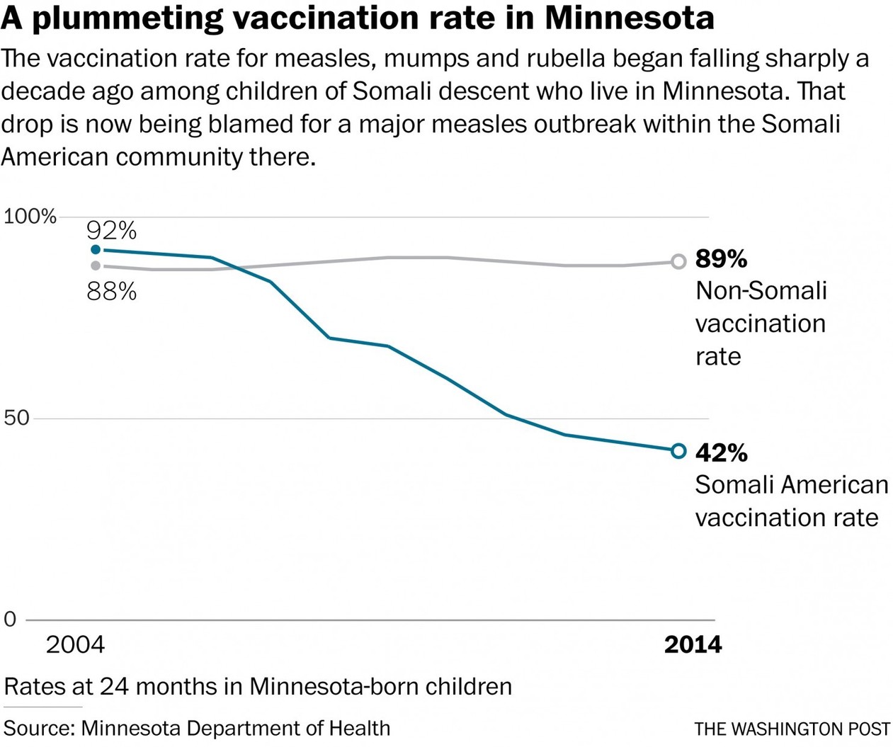
I had measles as a child. I am so disheartened to see this now-perfectly preventable disease that nearly killed me resurface in the United States because of a fear-baiting, anti-intellectual movement. The spread of any disease carries spatial component that interests geographers, but there is also cultural geographies that help to understand, explain, and (hopefully) combat this issue. Please vaccinate the ones you love.