Search

GEOGRAPHY EDUCATION

Supporting geography educators everywhere with current digital resources.

Tag

z unit 4 political

New census data projects which states could gain or lose congressional seats in 2020 reapportionment

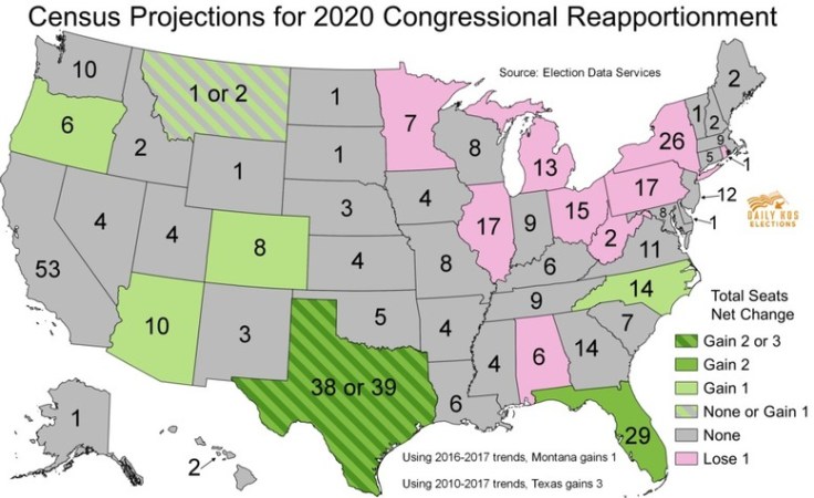
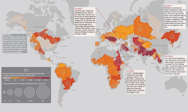
the Census Bureau released its population estimates for 2017 for every state, detailing how many residents each state has gained or lost since the 2010 census. The firm Election Data Services has used these estimates to project how many congressional seats each state might gain or lose in the 2020 round of reapportionment, which assigns each state its share of the House’s 435 districts based on its population.

Source: www.dailykos.com

Reapportionment is a forgotten step.  Before a state can redistrict the congressional districts within the state, every 10 years, the Federal government is constitutionally required to conduct a census with the main goal of being able to reapportion the congressional seats based on the decennial census.  The upcoming 2020 Census is big deal, showing regional population shifts with political ramifications.   

Tags: electoral, political, mapping.

WordPress TAGS: electoral,  political, mapping.

Challenges in Defining an Israeli-Palestinian Border

There are major hurdles in drawing borders between Israel and a future Palestine.

Israeli and Palestinian negotiators resumed peace talks in Washington in July for the first time in three years. While the talks are initially expected to focus on procedural issues, they are already beginning to take on a last-ditch quality. Explore some of the contentious issues that negotiators have faced in drawing borders between Israel and a future Palestinian state.

Source: www.nytimes.com

This five-part video report from the New York Times is from 2011, but still has some pertinent information, even if the situation has changed in some of the particulars.  These videos brings important voices from a variety of perspectives on the Israeli-Palestinian conflict; together they all  show how a complex cultural and political geography leads to many of the difficulties in creating a long-lasting peace.  The discipline of geography doesn’t simple study the peace process–it is a part of it.  The creation of borders and the cartographic process play a critical role in solving territorial issues.  Geography can be both the problem and the solution. 

Tags: Israel, borders, Palestine, territoriality, political, Middle East.

Where Do Borders Need to Be Redrawn? – Room for Debate

What parts of the world should rethink their maps? Why and how?

Source: www.nytimes.com

Maps are always changing as a new nation gets added and old lines cease to make sense. Territory is claimed and reclaimed.  This series of seven articles in the New York Times explores regional examples of how borders impacts places from a variety of scholarly perspectives.  Together, these article challenge student to reconsider the world map and to conceptualize conflicts within a spatial context.


Tags: bordersmapping, political, territoriality, sovereignty.

CrisisWatch: The Monthly Conflict Situation Report

Mapping global conflict month by month.

Source: crisisgroup.be

You and your students can browse through this interactive map for an update on conflict situations around the world.  The International Crisis Group is an independent, non-profit, non-governmental organization committed to preventing and resolving deadly conflict; they’ve created this interactive map to help us stay informed about the most important conflict issues around the world.  I’m placing this on my list of favorite resources as this is one worth returning to on a regular basis.

Tags:  conflict, political, geopolitics, best of the best.

CrisisMap

Where Will The World’s Water Conflicts Erupt?

As the climate shifts, rivers will both flood and dry up more often, according to the latest report from the Intergovernmental Panel on Climate Change. Shortages are especially likely in parts of the world already strapped for water, so political scientists expect feuds will become even more intense. To track disputes worldwide, researchers at Oregon State University spent a decade building a comprehensive database of international exchanges—-both conflicts and alliances—over shared water resources. They found that countries often begin disputes belligerently but ultimately reach peaceful agreements. Says Aaron Wolf, the geographer who leads the project, “For me the really interesting part is how even Arabs and Israelis, Indians and Pakistanis, are able to resolve their differences and find a solution.”

Source: www.popsci.com

Too often we think of political conflicts within the framework of state borders; this mapping project divides the world into watersheds and forces us to look at global politics through a different and enlightening lens (Hi-Res image).  Oil might be the most economically valuable liquid resource, but water is the most critical for human habitation.  This infographic is reminiscent of this one, asking where the next ‘water wars’ might take place.   


Tags: water, political, unit 4 political environment, conflict, infographic

Create a free website or blog at WordPress.com.

Up ↑