Search

GEOGRAPHY EDUCATION

Supporting geography educators everywhere with current digital resources.

Tag

unit 4 political

Will the Supreme Court End Gerrymandering?

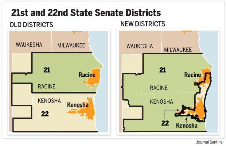
"Justices will be reviewing the case of North Carolina, where Republicans drew a map to maximize their power in the House. Plaintiffs challenging the map say it’s unconstitutional. A companion case centers on Maryland’s 6th Congressional District, which Democrats admit they redrew in 2011 to make it harder for the Republican incumbent there to win re-election. The two cases hold the potential to set the course of American politics for generations."

Source: www.nytimes.com

Questions to Ponder: Do you trust the politicians that are in charge of your state to create better districts than a computer-generated set of districts that are optimized for compactness?  What are some of the potential limitations of compact districts?  Would an independent committee/bipartisan group do a better job?

GeoEd Tags: gerrymandering, political, mapping, cartography, unit 4 political.

Tags: gerrymandering, political, mapping, cartography, unit 4 political.

Kosovo-Serbia land swap could end conflict – or restart war

“A land swap proposal between Kosovo and Serbia could end the last ethnic conflict of the Yugoslav Wars, or it could reignite it. The proposal involves swapping Serbian-majority district of Mitrovica in north Kosovo, and the Albanian-majority Presevo Valley, in southwest Serbia. The deal excludes 6 Serbian-majority municipalities within Kosovo.”

Source: bigthink.com

Land swaps are about fixing problematic borders–and we know that the world is full of problematic, contentious, and disputed borders.  Yet land swap are incredibly rare because it upends the status quo.  A few years back Belgium and Netherlands swapped some land, but more often then not, calls to simply give land to another country just because the land appears to be controlled by the ‘wrong’ country usually go unanswered.  This proposed swap is especially intriguing because (to an objective outside observer) it could benefit both countries and lead to a mutual recognition of their shared border.  This BBC podcast explores local impacts and opinions about borders, ethnic identity, and place.  

GeoEd Tags: borders, political, territoriality, unit 4 political, Serbia, Kosovo, Europe.

Scoop.it Tags: borders, political, territoriality, unit 4 political, Serbia, Kosovo, Europe.

New census data projects which states could gain or lose congressional seats in 2020 reapportionment

the Census Bureau released its population estimates for 2017 for every state, detailing how many residents each state has gained or lost since the 2010 census. The firm Election Data Services has used these estimates to project how many congressional seats each state might gain or lose in the 2020 round of reapportionment, which assigns each state its share of the House’s 435 districts based on its population.

Source: www.dailykos.com

Reapportionment is a forgotten step.  Before a state can redistrict the congressional districts within the state, every 10 years, the Federal government is constitutionally required to conduct a census with the main goal of being able to reapportion the congressional seats based on the decennial census.  The upcoming 2020 Census is big deal, showing regional population shifts with political ramifications.   

Tags: electoral, political, mapping.

WordPress TAGS: electoral,  political, mapping.

Somalia: The Forgotten Story

Part I: The story of Somalia’s decline from stability to chaos and the problems facing its people at home and abroad.

Part II: The ongoing civil war has caused serious damage to Somalia’s infrastructure and economy. Thousands of Somalis have either left as economic migrants or fled as refugees. Within Somali, more than a million people are internally displaced.


Tags: devolutionpolitical, states, unit 4 politicalmigrationrefugees, Somalia, Africa.

Source: www.youtube.com

This computer programmer solved gerrymandering in his spare time

We could take human error out of the redistricting process entirely. Why don’t we?

Source: www.washingtonpost.com

This computer programmer (code word in the newspapers for geographers using GIS) has created a way to take the human element out of the redistricting process.  Dividing places into separate, formal regions is an important task, one that often times requires an intimate knowledge of the place, it’s cultural, economic and physical characteristics.  That’s how I would want things to been done in a perfect world, but partisan chicanery has led to so many gerrymandered districts that the human touch is what many of us fear more than a cold, impersonal division that does not take place, history, and community into account.    


Questions to Ponder: Do you trust the politicians that are in charge of your state to create better districts than computer-generated districts that are optimized for compactness?  What are some of the potential limitations of compact districts?  Would an independent committee/bipartisan group do a better job? How does the Voting Rights Act complicate the redistricting process?    


Tags: gerrymandering, politicalmapping, cartography, GIS, unit 4 political.

Bill aims to ‘take politics’ out of drawing district lines

A Democratic state senator in South Carolina wants to end the practice of lawmakers choosing who votes for them. The senator introduced a bill Wednesday that would create an independent commission to draw the state’s political districts. Lawmakers in the GOP-controlled Legislature now control that process. South Carolina voters would approve or reject the boundaries of new political districts in a statewide referendum if the bill becomes law. The state redraws its political boundaries for South Carolina House, state Senate and U.S. House seats after each 10-year U.S. Census [the next Census is in 2020].”

Source: www.thestate.com

While it may be laudable to try eliminate partisan gerrymandering, this bill is going nowhere.  Still, it is an important issue to discuss. 


Questions to Ponder: What is the difference between the terms redistricting and gerrymandering?  Why won’t this bill pass? 

What is the fairest way to divide districts?


Tags: gerrymandering, political, census, unit 4 political.

Belgium and the Netherlands Swap Land, and Remain Friends

The discovery of a headless corpse in the Netherlands helped Belgium and its bigger Dutch neighbor resolve a property squabble that began in 1961.


In a region that has long known geopolitical and linguistic squabbles, and where Belgium has lived in the shadow of its neighbor, the land swap was anything but inevitable. In 1961, when the Meuse was reconfigured to aid navigation, it had the side effect of pushing three pieces of land onto the wrong side of the river. The uninhabited area subsequently gained a reputation for lawlessness, wild parties and prostitution.


Tags: borders, political, territoriality, BelgiumNetherlands, unit 4 political, Europe.

Source: www.nytimes.com

Judges Find Wisconsin Redistricting Unfairly Favored Republicans

A federal panel called the 2011 redrawing of Wisconsin Assembly districts an unconstitutional gerrymander, ruling in a case that could go to the Supreme Court.

Source: www.nytimes.com

The redistricting process is far from neutral; to be fair we should remember that gerrymandering has happened on all ends of the political spectrum, depending on who is charge during the redistricting process (after the decennial census).  Which map to you think is the best way to divide these districts?  What is the fairest way to divide them?

Tags: gerrymandering, political, mapping, census, unit 4 political.

Challenges in Defining an Israeli-Palestinian Border

There are major hurdles in drawing borders between Israel and a future Palestine.

Israeli and Palestinian negotiators resumed peace talks in Washington in July for the first time in three years. While the talks are initially expected to focus on procedural issues, they are already beginning to take on a last-ditch quality. Explore some of the contentious issues that negotiators have faced in drawing borders between Israel and a future Palestinian state.

Source: www.nytimes.com

This five-part video report from the New York Times is from 2011, but still has some pertinent information, even if the situation has changed in some of the particulars.  These videos brings important voices from a variety of perspectives on the Israeli-Palestinian conflict; together they all  show how a complex cultural and political geography leads to many of the difficulties in creating a long-lasting peace.  The discipline of geography doesn’t simple study the peace process–it is a part of it.  The creation of borders and the cartographic process play a critical role in solving territorial issues.  Geography can be both the problem and the solution. 

Tags: Israel, borders, Palestine, territoriality, political, Middle East.

Create a free website or blog at WordPress.com.

Up ↑