Search

GEOGRAPHY EDUCATION

Supporting geography educators everywhere with current digital resources.

Tag

California

Lake Tulare Reemerging

FIGURE 1: The Central Valley is a highly modified agricultural landscape. SOURCE: Big Think

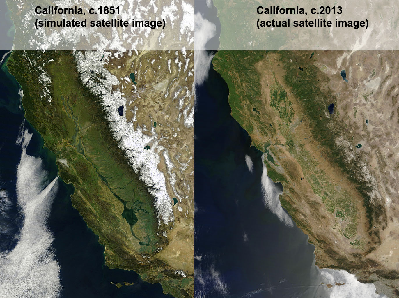
A few years ago, I was delighted to see an geographer’s rendition of what a satellite image of California would have looked if such a thing existed in the 1800s (figure 1). Back then the southern San Joaquin Valley was swampy wetland surrounding Lake Tulare, the largest freshwater lake west of the Mississippi River.  In the late 1800s, canals and dams were created to divert water from the rivers that fed into the lake to go supporting agriculture and the metropolitan areas of California.  As the very shallow lake dried up, the lakebed was converted into was converted to agricultural land, mainly under cotton cultivation. 

Figure 2: The Tulare Watershed with dry lake beds that are refilling. Source: KVPR

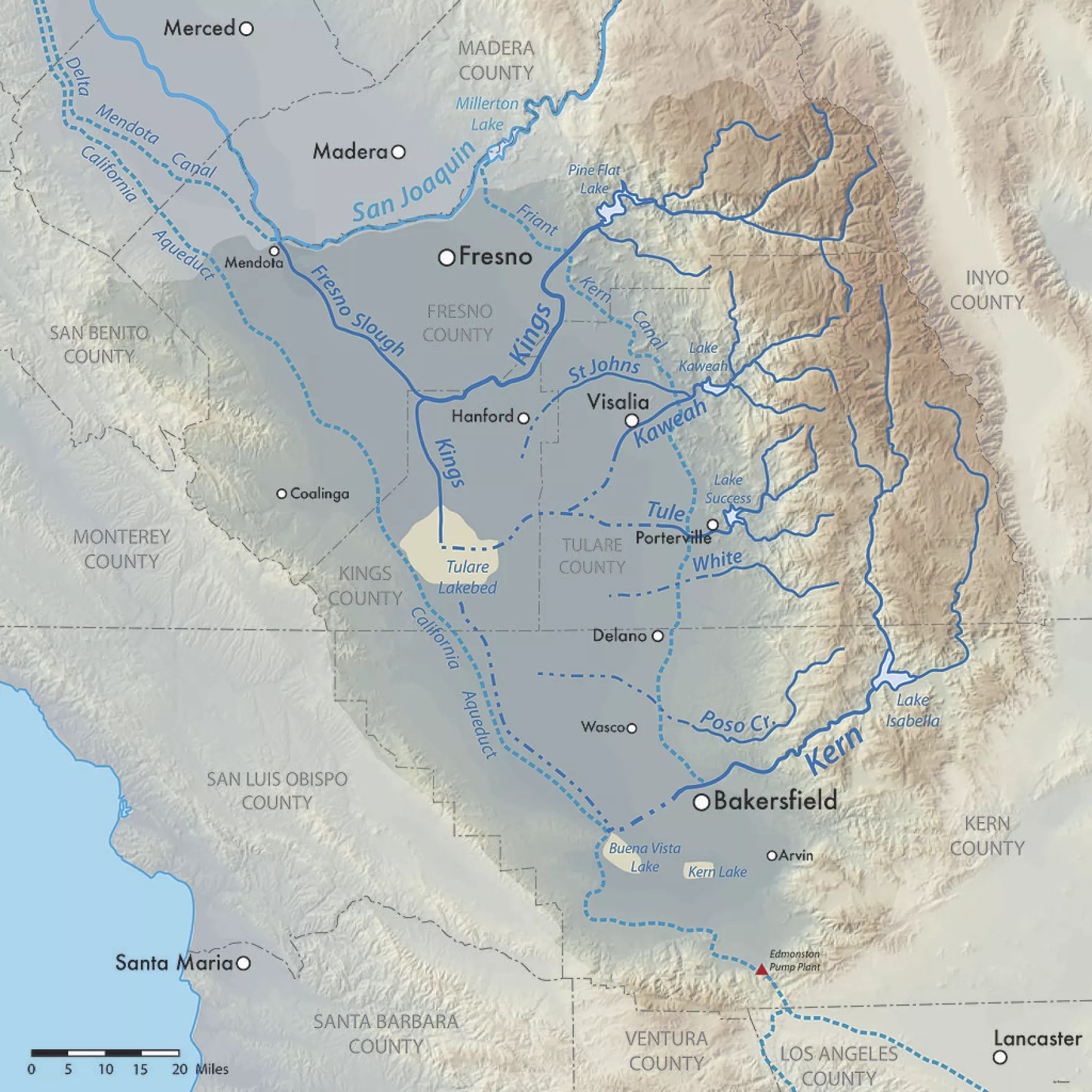
California and much of the wast have had far more precipitation than expected on the heels of years of drought. The existing canals and reservoirs in the watershed are overflowing and the dry lake bed with fields is getting flooded again; water doesn’t care about what is there now, it just flows downhill. Enter the 2023 version of Tulare Lake flooding farmland, roads, railways, towns, and other expensive infrastructure.

While it won’t return to its historic levels with one year’s snowpack, it’s likely that 100,000 acres (150 sq. miles) of farmland will be under water for two years, possibly more. This is a relatively lightly populated region, but some cities like Corcoran, CA (22,000 people) are on the edge of the old lake bed and might need to be partially evacuated as levees have failed to stem the tide. 

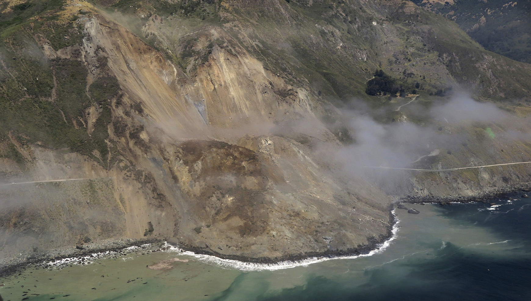
Agricultural companies and local towns are both trying to protect their lands from flooding to protect their infrastructure, equipment, homes, and people.  At times, these goals are at odds with one another, and armed guards are protecting levees and hydrologic projects. Below are two videos that are good introductions to the topic of the reemergence of Lake Tulare.   

Questions to Ponder: How has agriculture and urbanization modified your state’s geography? What are the positive impacts of these modifications? What are potential negative consequences of these modifications?

TAGS: environmental modification, California, environment.

VIDEO#1: Limited geography, but a good 4 minute local news-type explanation.
Video #2: More in-depth (15 min.), with historical background on the hydrology of the region.

Beaches, Pollution, Governance, and Scale

Coronado Beach scene from the movie, “Top Gun: Maverick.” Point Loma peninsula in the background.
Local Area

I was in the waves, enjoying the beach on my vacation to San Diego, when the importance of geographic scale to political governance hit me (I know, I’m a geography nerd…guilty).  Local, state, national, and international organizations administer laws and regulations over space, and there are going to be overlapping jurisdictions and different priorities at different scales.  I visited the two beaches I always went to as a kid, Coronado and Imperial Beach (IB).  These are the two most southern beaches in California, and Coronado is now famous for the Top Gun: Maverick beach scenes with Point Loma in the background.  Not surprisingly, tourism is incredibly important to these beach communities, especially in the summer.  As is often the case, this little case study shows how geographic topics and scales are interlinked on the ground (or in the water as it were). 

Imperial Beach is famous for it’s sandcastle festivals.

INTERNATIONAL CONTEXT: The Tijuana River flows through downtown Tijuana and crosses the U.S. border before emptying into the Pacific Ocean.  The river is heavily industrialized in Mexico with pollutants and sewage from the major urban area of Tijuana, but the river is treated as a wetlands wilderness preserve in the once it crosses into the United States (downstream of the pollutants).    

The Tijuana River cares not for international borders and differing regulations.

LOCAL (CITY) CONTEXT: The South Bay beach communities have built a summer economy around surfing, sandcastles, and chilling at the beach.  This municipalities generate a substantial portion of local revenue from the shops, restaurants, and businesses (Hotel Del Coronado is the most famous seaside venue here). 

COUNTY CONTEXT: In May, 2022, San Diego County changed their methods of testing water quality.  They implemented a DNA test to screen for bacteria in the water.  This test is more sensitive that the older tests and San Diego County is the only county in the U.S. using this heightened standard to measure water quality at the beach.      

PANDEMIC CONTEXT: Public health is more on the forefront of people’s radar and many agencies are more risk averse than individuals. 

SITUATION: The water at Imperial Beach, Silver Stand, and Coronado failed the new 2022 test more often than not even if it would have passed by the old standard.  May and early June, the beaches were closed over 50% of the time. San Diego County cities can’t control the Tijuana River much before it crosses back into the United States, so they are limited on options to clean up the river, but the Federal government though, through the EPA, announced in 2021 that a $300 million initiative in conjunction with the Mexican government.  This summer, Coronado has had to cancel large regional events and now the mayors, city councils, business leaders, and residents are pushing back against the new county testing procedures, citing economic damage to their communities. They have settled on a new advisory system that includes a comprise warning—one  where the state is acknowledging that the water is polluted (3% chance of getting sick), but that people who have been to these beaches for years can choose for themselves to swim or not.    

What is the right choice?  Depends on your priorities (maintaining the tourist economy or public health benefits?) and the scale at which you are looking at the situation. 

Tags: California, coastal, scale, environmental, political, pollution.

Hotel Del Coronado is both a landmark and a cash cow (featured in Marilyn Monroe’s “Some Like it Hot.”)

Displacement from Gentrification

Source: www.youtube.com

How does gentrification displace longtime residents?  How does the community change during the gentrification process?  What are the impacts to residents (current and former) of the gentrification process?  This is one young man’s story about gentrification in San Francisco’s Mission District. 


Tags: neighborhood, gentrificationurban, place, culture, economic

Alluvial Fans

“When a mountain stream carries a lot of sediment (clay, silt, sand, gravel, cobbles, and boulders) and leaves the confines of the canyon, the sediment is deposited. Over time, this process creates a fan-shaped deposit. The sediment is deposited not because the gradient of the stream decreased, but because the power of the stream dissipates beyond the canyon mouth as the water is spread thin and infiitrates. Many cities are built on alluvium fans, often leading to hazards from flash floods and mudflows.”

Source: www.instagram.com

In mountainous, interior deserts, the largest settlements are usually not deep in the deserts or on top of the mountains but in that in between space.  Many settlements in Central Asia are built on these alluvial fans


Tags: environment, physical, geomorphology, erosiongeology, California, landforms.

Burn Scars on California’s Wine Country

Devastating wildfires burned through California’s wine country in October 2017, taking several lives and leaving thousands of people homeless. On October 21, the Advanced Spaceborne Thermal Emission and Reflection Radiometer (ASTER) on the Terra satellite acquired this false-color image of the burn scars left by the Tubbs (upper left), Nuns (center), and Atlas (lower right) fires. Unburned vegetation appears red; burned vegetation appears brown. Buildings, roads, and other developed areas appear light gray and white.”


Tags: remote sensingdisasters, California, physical.

Source: earthobservatory.nasa.gov

The Edge of the Plates

“Tomales Bay lies about 50 kilometers (30 miles) northwest of San Francisco, along the edges of two tectonic plates that are grinding past each other. The boundary between them is the San Andreas Fault, the famous rift that partitions California for hundreds of miles. To the west of the Bay is the Pacific plate; to the east is the North American plate. The rock on the western shore of the Bay is granite, an igneous rock that formed underground when molten material slowly cooled over time. On the opposite shore, the land is a mix of several types of marine sedimentary rocks. In Assembling California, John McPhee calls that side “a boneyard of exotica,” a mixture of rock of ‘such widespread provenance that it is quite literally a collection from the entire Pacific basin, or even half of the surface of the planet.'”


Tags: geomorphologyremote sensing, tectonics, geology, Californiacoastal, physical.

Source: earthobservatory.nasa.gov

How Does it Grow? Garlic

How Does it Grow? Garlic from How Does it Grow? on Vimeo.

Telling the stories of our food from field to fork.
Episode Two: Peeling back the layers of nature’s most powerful superfood.

Source: vimeo.com

This 5-minute video is a good introduction to garlic, it’s production, environmental requirements, nutritional profile and diffusion.  Historically, garlic was far more important than I ever imagined.  The geography of food goes far beyond the kitchen and there are many more episodes in the “How Does it Grow?” series to show that.

Tags: foodeconomicfood production, agribusiness, industryvideo, agriculture.

With only one left, iconic yellow road sign showing running immigrants now borders on the extinct

Only one of the 10 iconic Caltrans caution signs emblazoned with the image of an immigrant father, mother and daughter running for their lives remains. They once dotted Interstate 5.

Source: www.latimes.com

As a child of the border (I grew up 8 miles from the U.S.-Mexican border with family on both sides of the line), the cultural, political and economic impacts of this line were very tangible in my life, but to mention family.  This sign was a symbol of mass migration and cultural change in Southern California and I would pass one on the way to my grandmother’s house.  As a fixture of the cultural landscape, it also became a visual talking point that served as a lightning rod in the political landscape.  During the 80’s and 90’s, immigrants from Mexico were coming in to the United States is large numbers, but since the 2000, that dominant stream has dried up, rendering this sign no longer necessary near freeways crossings.  Mexican migration to and from the United States is a contentious topic where political ideology can be louder than the actual statistics.  Since 2009, more Mexicans have been leaving the United States than entering it (PEW Research Center).  Economic and demographic shifts in both countries have led to this reversal.    


Tags: Mexico, migration, political, landscape, California, borders.   

Massive landslide adds to ‘unprecedented’ damage along scenic Highway 1 in Big Sur area

“A massive mudslide along the California coast.  Millions tons of rock/dirt, about 1/3 mile of roadway covered 35-40 feet deep.”

Source: www.latimes.com

A steep slope, unstable ground, and changing moisture content result is this spectacular (and horrifying) example of how the Earth beneath our feet might not be as permanent as we expect it to be.


Questions to Ponder: Which type of mass wasting is seen in this particular example?  What conditions would lead to other types of mass wasting?  


Tags: physicalCalifornia, geomorphology, erosion, landforms.

Blog at WordPress.com.

Up ↑