Search

GEOGRAPHY EDUCATION

Supporting geography educators everywhere with current digital resources.

Tag

water

Manila Times Gives China The Finger With Its Own “Nine Dash Line” Map

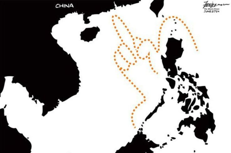
"The Philippines’ oldest newspaper recently made what could be considered a provocative gesture towards China regarding its notorious nine-dash-line."

Source: saigoneer.com

I’ve shared some more substantial resources about maritime claims in the South China Sea than this flippant political cartoon.  Still, this cartoon beautifully illustrates a geopolitical perspective quite powerfully.  As always, use your own discretion when sharing resources in your own classroom (my college students love this). 


GeoEd Tags: borders, Political, conflict, water, Philippines, China.

Scoop.it Tags: borders, political, conflict, water, PhilippinesChina.


USGS’s Streamer Tool

Streamer is a new way to visualize and understand water flow across America. With Streamer you can explore our Nation’s major streams by tracing upstream to their source or downstream to where they empty.

Source: txpub.usgs.gov

Streamer is the online mapping application that lets anyone explore downstream and upstream along America’s rivers and streams (here is a YouTube tutorial). Streamer can be used to follow the paths of rivers up to their headwaters and down to the sea, to view location-related information such as weather radar and near real-time streamflow data, and to discover hydrologic connections between distant places.


Scoop.it Tags: water, mapping, physical, fluvial, regions.

WordPress TAGS: water, mapping, physical, fluvial, regions.

Identifying Illegal Overfishing

"The vast majority of fishing vessels follow the rules governing fishing – but many are not, and these bad actors can cause a lot of damage. Vessels may take too many fish ­– overfishing – which is causing our fisheries to collapse. Then there is the problem of illegal fishing, which can occur in protected areas, in another country’s waters or on the high seas. This threatens jobs and food security for millions of people, all around the world.

The trouble is, so much of this illegal activity is hidden – it happens out to sea, making it difficult to scrutinize what individual vessels are getting up to. Fortunately, we are now beginning to see what happens after commercial fishing vessels leave port.

The interactive map we created allows anyone in the world with an internet connection to see the activities of the commercial fishing fleet globally."


Scoop.it Tags: water, conservation, biogeography, environmentpollution, resourcesmappingfood production, agriculture.

WordPress TAGS: water, biogeography, environment, pollution, resources, mapping, food production, agriculture.

Source: www.bbc.com

Damaged and defiant: Hurricane Harvey

Houston holds strong in the wake of devastation left by Hurricane Harvey.

Source: www.houstonchronicle.com

I am sharing these three interactive webmaps of Houston with my mapping courses to demonstrate what is technologically possible.  Texts, charts, pictures, videos, and maps can be seamlessly integrated to present spatial information in an incredibly engaging and accessible manner.  

Houston’s Hurricane Harvey was incredibly impactful but the factors leading to this were also very complex.  These three Story maps lay out:

  1. Houston’s urban ecological context
  2. The geographic origins of Hurricane Harvey
  3. The human stories from Hurricane Harvey


Scoop.it Tagsphysical, watercoastal, urbanurban ecology, disasters, mappingESRIStoryMap.

WordPress TAGS: physical, water, coastal, urban, urban ecology, disasters, mapping, esri, storymap.

Pacific nation Tuvalu has grown by 73 hectares over 40 years

“The tiny Pacific nation of Tuvalu – once thought to be under threat from rising sea levels – has grown the size of California’s Disneyland over the past 40 years. It’s mostly thanks to waves dumping extra sediment, sand and gravel on shore lines, according to research by Auckland University scientists. The study, published in the Nature Communications journal on Friday, was the first in-depth look at how much each of Tuvalu’s 101 islands have changed over the decades.”


Tags: Oceaniawatercoastal, environment, physical, geomorphology, erosiongeology, landforms.

Source: www.stuff.co.nz

South Africa Is Still Under Apartheid

“More than two decades after the end of apartheid in South Africa, Cape Town remains racially segregated, with many black residents living in substandard townships.”

Source: www.youtube.com

The title is a bit inflammatory–news agencies may pretend that they aren’t in the shock-and-awe, clickbait economy, but they invented the salacious headline to grab our attention.  Still, the racial inequities of a system as pervasive as apartheid aren’t going to be reversed in a generation and the racial differences in Capetown are coming under more international scrutiny as the they are in the midst of their current drought.


Tags: South Africa, Africarace, ethnicityneighborhood, urban, planning, drought, water, urban ecology.   

How to Defeat Drought

Cape Town is running out of water. Israel offers some lessons on how to avoid that fate.

Source: foreignpolicy.com

Most droughts are caused by a combination of human and physical geographic factors. Cape Town is current in the midst of a 3 year long drought that is causing many officials to consider drastic measures such as cutting off all private water taps and rationing out 13 gallons per resident per day.  


I would like for us to also consider cases beyond South Africa, and think about the the broader issues of resource management, urbanization, resilience, and changing climatic conditions.  Resources Watch discusses critical water shortages in Morocco, India, Iraq and Spain with excellent maps, charts, and graphs. This article from Foreign Policy demonstrates how Israel has worked to maximize their minimal water resources (recycling grey water for agriculture and desalinization). The World Resources Institute discusses 3 things cities can glean from the South African crisis (1. Understand risks, 2. Manage the water budget, and 3. Invest in resilience).  


Tags: drought, water, environment, technologyenvironment modify, South AfricaIsrael, Spain, MoroccoIndiaIraq.

Houston’s stories of Hurricane Harvey

“Blue and her team selected 45 stories, each plotted with ESRI’s ArcGIS software on a map of Greater Houston and tied to the exact location where it was first told. The resulting story map of Hurricane Harvey, ‘Damaged and Defiant: Houston Stories,’ was published in the Houston Chronicle in December. The map shows short narratives gathered by Chronicle staffers from people across the area — from Crosby to Kingwood to Katy — each a unique perspective on the storm; told together, they’re the collective account of a city that experienced one of the worst natural disasters in U.S. history.”

Source: news.rice.edu

These interlinked Houston story maps show some of the key elements of a good story map: 1) strong spatial analytical components, 2) a powerful narrative, 3) rich visuals, 4) solid cartography, and 5) well-sourced information.


Tags: fluvialwatercoastal, urban, disasters, physical, mappingESRIStoryMap.

The 10 Worst River Basins Contributing to Ocean Plastics

“[A new paper], published in the journal Environmental Science and Technology, calculates that rivers contribute between 410,000 and 4 million tonnes a year to oceanic plastic debris, with 88 to 95% [of that total] coming from only 10. Those rivers are the Yangtze, Yellow, Hai He, Pearl, Amur and Mekong in east Asia, the Indus and Ganges Delta in south Asia, and the Niger and Nile in Africa.”

Source: cosmosmagazine.com

Of river-based plastic pollution, these 10 rivers are responsible for 88%-95% of all the plastic gyrating in the world’s oceans.  Improvement in these key places could make a world of difference in improving marine ecosystems (NOTE: the map came from this alternative article on the same subject).


Tags: pollution, water, environmentsustainability, consumption, fluvial.

Create a free website or blog at WordPress.com.

Up ↑