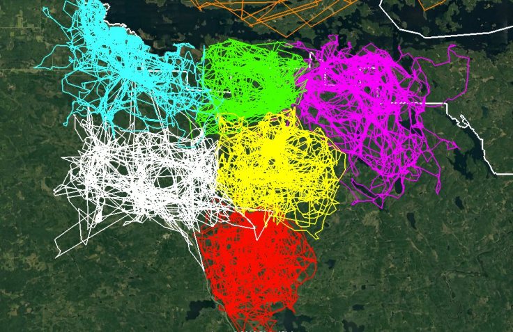
Search

GEOGRAPHY EDUCATION

Supporting geography educators everywhere with current digital resources.

Tag

biogeography

GPS Tracking

wolf_packs_gps_image

This image of GPS tracking of multiple wolves in six different packs around Voyageurs National Park was created in the framework of the Voyageurs Wolf Project. It is an excellent illustration of how much wolf packs in general avoid each other’s range.” SOURCE: Earthly Mission

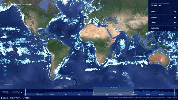
Maps are powerful tools to demonstrate spatial ideas and concepts.  Wolves are territorial, and using GPS trackers to understand this really drives home the point.  Here is a similarly fantastic map of an eagle’s flight paths shows the patterns amid noise.

gps-tracks-eagle-movement-over-twenty-years-5c79333418b97__700

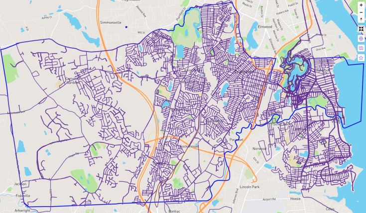
As a runner, I keep track of my all my runs using some apps and Citystrides.com.  A screengrab of my “LifeMap” is included below.

Running GPS

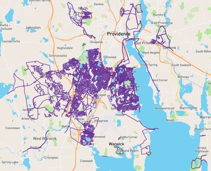
With these tools at my disposal I stumbled on the decision to learn about my city by running every single street, exploring the cultural landscape, and make the training miles a part of a bigger goal.  With this newfound understanding of my city, I’ve mapped over 100 changes on OpenStreetMap (OSM) to give my newfound knowledge a bit of public utility.  The light blue line in the image below is the Cranston (RI) city boundary; As of March 12, I’ve officially run #EverySingleStreet, 100% of Cranston roads.  It was a quixotic goal, but an absolutely thrilling way to comibne my love of running, cartography, Cranston, and exploring the cultural landscape.

100percent
15 months in the making, a map documenting my runs on #EverySingleStreet of Cranston.

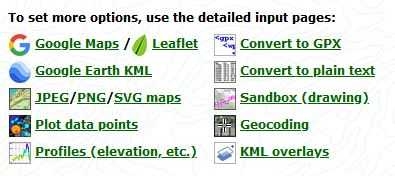
TOOLS: Using GPS data in mapping tools such as ArcGIS.com or Google Earth doesn’t require a lot of expertise, but gathering the data out in the field can usually be done with an app that can create a .GPX file (search your app store for GPX).  You can use GPS Visualizer to convert files, create GPX files or convert files to other formats.  Look at the screengrab below to see some of the options, especially the ‘sandbox’ tool which lets you create a GPX file.

GPS

GeoEd Tags: GPS, mapping, biogeography.


The Mysterious Life (and Death) of Africa’s Oldest Trees

"Learn about one of the world’s most iconic tree species, the baobab tree, and discover why these endangered trees might be on their way to extinction—or might outlive us all."

Source: www.topic.com

So are the endangered baobab trees victims of the effects of climate change?  The baobab, which has made so many wax poetic, is undergoing a steep decline.  Although scientists are unsure of the reasons and possible solutions, this is a nice piece exploring the cultural and ecological significance of one of the more magnificent trees on our planet.      


GeoEd Tags: biogeography, environment, ecology, Africa,political ecology, Botswana.

 Scoop.it Tags: biogeography, environment, ecology, Africa, political ecology, Botswana.

Identifying Illegal Overfishing

"The vast majority of fishing vessels follow the rules governing fishing – but many are not, and these bad actors can cause a lot of damage. Vessels may take too many fish ­– overfishing – which is causing our fisheries to collapse. Then there is the problem of illegal fishing, which can occur in protected areas, in another country’s waters or on the high seas. This threatens jobs and food security for millions of people, all around the world.

The trouble is, so much of this illegal activity is hidden – it happens out to sea, making it difficult to scrutinize what individual vessels are getting up to. Fortunately, we are now beginning to see what happens after commercial fishing vessels leave port.

The interactive map we created allows anyone in the world with an internet connection to see the activities of the commercial fishing fleet globally."


Scoop.it Tags: water, conservation, biogeography, environment, pollution, resources, mapping,  food production, agriculture.

WordPress TAGS: water, biogeography, environment, pollution, resources, mapping, food production, agriculture.

Source: www.bbc.com

How Cookiecutter Sharks Eat Is Terrifying

Do not be fooled by its adorable name—the cookiecutter shark attacks by suctioning its lips to the flesh of its victims, spins, and ejects a cylindrical plug of flesh from its prey!

Source: www.youtube.com

This is the most delightfully fun video about one of the creepiest critters of the deep. 


Tags: water, biogeography, environment, physical, National Geographic.

Jackalopes Return to Yellowstone Ecosystem

After a 93 year hiatus, the elusive Jackalope has returned to the greater Yellowstone ecosystem! These beautiful, yet frightening, creatures were once widely collected by tourists, but better management practices have allowed a re-introduced pack to thrive again. These guys have been sporadically spotted all around the west, including Wyoming, Montana, Colorado, and New Mexico. Idaho allowed a “shoot on sight” policy for jackalopes, so they have not been seen there in quite a while.

Source: jellostone.com

Long live the Jackalope!!  May the majestic creature once again flourish in the West. 


Tags: biogeography, environmentecology, fun.

Senegal’s Great Green Wall combats desertification

“A 7,000 km barrier is being built along the footsteps of the Sahara to stop the desert expanding. The Great Green Wall project started in 2007 in Senegal, along with 10 countries in Africa to combat the effects of climate change. Al Jazeera’s Nicolas Haque reports from Widou, deep in the Sahel.”

Source: www.youtube.com

The Great Green Wall initiative is composed of 11 countries that are cooperating together to combat the physical and human geographic characteristics that make the Sahel one of the more vulnerable ecosystems in the world.  This swath running through Africa is the transition zone where tropical Africa meets the Sahara.  The Sahel is susceptible to drought, overgrazing, land degradation and desertification.  These issues of resource management and land use transcend international borders so this “Green Wall” was created with the intent to protect the environment, landscapes and people of the Sahel from desert encroachment (the shorter, social media friendly version of this video is available here).


Tags: Africa, Senegal, development, environment, waterbiogeography, ecology, environment depend, physical, weather and climate, supranationalism, political ecology.

The Sargasso Sea

“The Sargasso Sea occupies almost two thirds of the North Atlantic Ocean. Within this sea, circling ocean currents accumulate mats of Sargassum seaweed that shelter a surprising variety of fishes, snails, crabs, and other small animals. The animal community today is much less diverse than it was in the early 1970s, when the last detailed studies were completed in this region. This study shows that animal communities in the Sargasso Sea are definitely changing. The next step is to find out why.”

Source: www.youtube.com

Often, we define oceans and seas based on their borders with land as their defining characteristics (this is one reason why many don’t know about the Southern Ocean as a distinct body of water or consider it an ocean). The Sargasso Sea is defined by ocean currents; it is surrounded by great currents but is itself without a strong current, making it perilous for early seafarers.  These oceanic doldrums became shrouded in superstition as stories of the fabled Bermuda Triangle spread, but the truth is all in the ocean currents.   


Tags: water, biogeography, environment, physical.

Skokomish River salmon cross the road

“Watch salmon race across the road on their way to spawn; for more footage, watch this extended version.”

Source: www.youtube.com

We often see examples of how human modifications to ecosystems or watersheds have devastatingly negative impacts.  This is a remarkable example from Washington’s Olympic Peninsula that shows the resiliency of natural systems to overcome human modifications to the physical landscape.  If you study the world, you will always have something to both amaze and surprise you.   


Tagsfluvial, biogeography, environment, geomorphology, physicalwater, environment adapt, environment modify.

The Whale’s Tail

“The Ballena Marine National Park is located in Puntarenas, at the South Pacific coast of Costa Rica.” 

Source: www.ballenainfocenter.com

This National Park in Costa Rica is a delightful example of many things geographic.  Not only is the local biogeography make this a place famous for whales (ballena in Spanish), but the physical geography also resembles a whale’s tail.  This feature is called a tombolo, where a spit connects an island or rock cluster to the mainland. Additionally, there is also a great community of citizen cartographers mapping out this park and the surrounding communities. 


Tagsbiogeography, environment, geomorphology, physicalwater, landforms.

Blog at WordPress.com.

Up ↑