Search

GEOGRAPHY EDUCATION

Supporting geography educators everywhere with current digital resources.

Tag

spatial

Inside Hong Kong’s cage homes

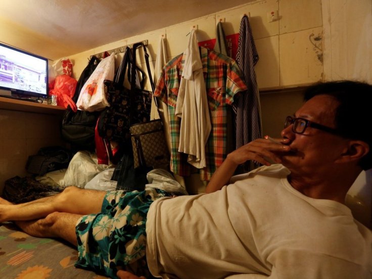
Hong Kong is the most expensive housing market in the world. It has been ranked as the least affordable housing market on Earth for eight years in a row, and the price per square foot seems to be only going up. The inflated prices are forcing Hongkongers to squeeze into unconventionally small spaces that can affect their quality of life.

Source: www.youtube.com

Land scarcity is usually the main culprit behind extremely high real estate markets in the world’s most expensive housing markets.  Silicon Valley, New York City, and other urban areas that are magnets for a young, well-educated workforce have very high costs of living.  The rising property values and rents make living in a city on the rise difficult for many of the residents that aren’t a part of the economic rising tide (gentrification is just particular example).   

Hong Kong is a very peculiar example were land scarcity is only a part of the situation.  Bad land use (3.7% zoned for high density housing) policy and land management are bigger culprits.  The government essentially owns all the land in Hong Kong and leases it to developers, so developers are incentivized to drive up that rates, given that the government doesn’t want to tax the corporations for the land that they occupy.

Season 2 of Vox borders has 5 episodes about Hong Kong:

  1. How British rule shaped Hong Kong
  2. China is erasing its border with Hong Kong
  3. Feng shui shaped Hong Kong’s skyline
  4. Decline of Hong Kong’s neon glow
  5. Hong Kong’s cage homes (profiled above)

Scoop.it Tags: housingurban, spatialdensity, planning, urbanism, China.

WordPress TAGS: housing, urban, spatial, density, planning, urbanism, China.

Maya civilization was much vaster than known, thousands of newly discovered structures reveal

Scientists using high-tech, airplane-based lidar mapping tools have discovered tens of thousands of structures constructed by the Maya.


Archaeologists have spent more than a century traipsing through the Guatemalan jungle, Indiana Jones-style, searching through dense vegetation to learn what they could about the Maya civilization. Scientists using high-tech, airplane-based lidar mapping tools have discovered tens of thousands of structures constructed by the Maya: defense works, houses, buildings, industrial-size agricultural fields, even new pyramids.

The lidar system fires rapid laser pulses at surfaces and measures how long it takes that light to return to sophisticated measuring equipment. Doing that over and over again lets scientists create a topographical map of sorts. Months of computer modeling allowed the researchers to virtually strip away half a million acres of jungle that has grown over the ruins. What’s left is a surprisingly clear picture of how a 10th-century Maya would see the landscape.

Tags: lidar, spatial, remote sensing, geospatial, unit 1 GeoPrinciplesGuatemala, Middle America.

Source: www.washingtonpost.com

Hong Kong’s ‘coffin homes’ reveal a housing crisis

A shortage of developable land have pushed Hong Kong’s housing prices skyward, leading some to live in spaces the size of closets.

Source: www.businessinsider.com

Overpopulation doesn’t feel like a serious issue when you live in a land characterized by wide open spaces, but in some densely settled urban centers, the issues become quite personal.  Hong Kong is currently facing a housing shortage. This article nicely explains the difficulties that living in the so-called coffin homes makes for the residents.  This photo gallery humanizes this difficult living condition.


Tags: housingurban, place, neighborhoodspatialdensity, planning, density, urbanism.

The path of the solar eclipse is already altering real-world behavior

The highly anticipated event is casting a long shadow online.


The upcoming solar eclipse is poised to become the “most photographed, most shared, most tweeted event in human history,” in the words of one astronomer. Millions of people will watch it, potentially overwhelming the cities and towns along the eclipse’s path of totality.

According to Google, interest in the eclipse has exploded nationwide in the past few months, mirroring national media attention. The county-level search data above, provided by Google, paints a striking picture: Interest in the eclipse is concentrated in the path of totality that cuts through the middle of the country, receding sharply the farther you go from that path.


Tags: Sunspace, media

Source: www.washingtonpost.com

Mapping the human impact on the Great Lakes

“It’s no secret that the Great Lakes are suffering tremendous ecological strain — Lake Erie was even pronounced “dead” for a time during the 1960s because of an overload of phosphorus from municipal waste. Back in 1615, though, when the entire region was pristine and explorers Samuel de Champlain and Étienne Brûlé gazed out together from Lake Huron’s shores, they dubbed it la mer douce, ‘the sweet sea.’ Today roughly one-quarter of Canada’s population and a 10th of America’s population drink from the Great Lakes basin; the beleaguered lakes alone hold more than a fifth of Earth’s freshwater.”

Source: www.canadiangeographic.ca

Questions to Ponder: What watershed do you live in?  Where does your drinking water come from?  When you flush the toilet, where does it go? How are places in your watershed linked?  How does this similar map shed more light on these issues?  


TagsCanada, environment, resources, waterspatial, scale

Reality can be a Matter of Perspective

Human eyes could be easier to trick than you might think. A Japanese professor, Kokichi Sugihara, created sculptures that trick the mind to see the impossible. He was the winner of the Best Illusion of the Year Contest in 2010 and 2nd place in 2016.”


Tags: spatial, perspective. 

Source: www.youtube.com

Petra, Jordan: Huge monument found ‘hiding in plain sight’

“Two archaeologists, who recently published their findings in the American Schools of Oriental Research, used Google Earth satellite images and drone photography to identify the outline of an enormous monument buried beneath sand and time at the UNESCO World Heritage site in Jordan.”  —Motherboard

Source: www.bbc.com

When in the Mexican state of Veracruz as a grad student, I saw a startling mountain covered by the dense tropical rain forest; this mountain had a consistent slope with hard angles.  I was awestruck to realize that it was an uncovered (but not undiscovered) pyramid and I wondered just how many archeological sites are waiting to be unearthed. 


Why is a geographer an important member of an interdisciplinary team? This discovery shows that spatial thinking, geographic tools, and a keen eye for usually patterns in unexpected places are critical for many disciplines and fields of research.


Tags: spatial, remote sensing, geospatial, MiddleEast, Jordan, googleunit 1 GeoPrinciples.  

Why do competitors open their stores next to one another?

“Why are all the gas stations, cafes and restaurants in one crowded spot? As two competitive cousins vie for ice-cream-selling domination on one small beach, discover how game theory and the Nash Equilibrium inform these retail hotspots.”

Source: www.youtube.com

This TED-ED lesson shows the economic and spatial factors that lead to businesses to cluster together.  This video is a very simple introduction to the concept of agglomeration that is based on competition.


Tags: APHGTED, models, spatialK12, location.

Blog at WordPress.com.

Up ↑