Search

GEOGRAPHY EDUCATION

Supporting geography educators everywhere with current digital resources.

Tag

fluvial

USGS’s Streamer Tool

Streamer is a new way to visualize and understand water flow across America. With Streamer you can explore our Nation’s major streams by tracing upstream to their source or downstream to where they empty.

Source: txpub.usgs.gov

Streamer is the online mapping application that lets anyone explore downstream and upstream along America’s rivers and streams (here is a YouTube tutorial). Streamer can be used to follow the paths of rivers up to their headwaters and down to the sea, to view location-related information such as weather radar and near real-time streamflow data, and to discover hydrologic connections between distant places.


Scoop.it Tags: water, mapping, physical, fluvial, regions.

WordPress TAGS: water, mapping, physical, fluvial, regions.

Houston’s stories of Hurricane Harvey

“Blue and her team selected 45 stories, each plotted with ESRI’s ArcGIS software on a map of Greater Houston and tied to the exact location where it was first told. The resulting story map of Hurricane Harvey, ‘Damaged and Defiant: Houston Stories,’ was published in the Houston Chronicle in December. The map shows short narratives gathered by Chronicle staffers from people across the area — from Crosby to Kingwood to Katy — each a unique perspective on the storm; told together, they’re the collective account of a city that experienced one of the worst natural disasters in U.S. history.”

Source: news.rice.edu

These interlinked Houston story maps show some of the key elements of a good story map: 1) strong spatial analytical components, 2) a powerful narrative, 3) rich visuals, 4) solid cartography, and 5) well-sourced information.


Tags: fluvialwatercoastal, urban, disasters, physical, mappingESRIStoryMap.

The Real Threat to Hinduism: The Slow Death of India’s Rivers

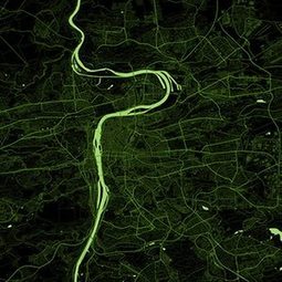
Hinduism shares an intricate, intimate relationship with the climate, geography, and biodiversity of South Asia; its festivals, deities, mythology, scriptures, calendar, rituals, and even superstitions are rooted in nature. There is a strong bond between Hinduism and South Asia’s forests, wildlife, rivers, seasons, mountains, soils, climate, and richly varied geography, which is manifest in the traditional layout of a typical Hindu household’s annual schedule. Hinduism’s existence is tied to all of these natural entities, and more prominently, to South Asia’s rivers.


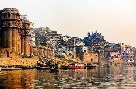
Hinduism as a religion celebrates nature’s bounty, and what could be more representative of nature’s bounty than a river valley? South Asian rivers have sustained and nourished Hindu civilizations for centuries. They are responsible for our prosperous agriculture, timely monsoons, diverse aquatic ecosystems, riverine trade and commerce, and cultural richness.  Heavily dammed, drying in patches, infested by sand mafia and land grabbers, poisoned by untreated sewage and industrial waste, and hit by climate change — our rivers, the cradle of Hinduism, are in a sorry state.


If there is ever a threat to Hinduism, this is it. Destroy South Asia’s rivers and with it, Hinduism’s history and mythology will be destroyed. Rituals will turn into mockery, festivals, a farce, and Hinduism itself, a glaring example of man’s hypocritical relationship with nature. The fact that we worship our rivers as mothers and then choke them to death with all sorts of filth is already eminent.

Source: thediplomat.com

This might be a controversial op-ed because it has a strong perspective on the religious and environmental dimensions of modern Indian politics…that said, I think it is well worth the read.  The Ganges is both a holy river, and a polluted river; that juxtaposition leads to many issues confronting India today. 


Tagsculturereligion, India, South Asia, Hinduism, pollution, industry,   environment, sustainability, consumption, fluvial

The 10 Worst River Basins Contributing to Ocean Plastics

“[A new paper], published in the journal Environmental Science and Technology, calculates that rivers contribute between 410,000 and 4 million tonnes a year to oceanic plastic debris, with 88 to 95% [of that total] coming from only 10. Those rivers are the Yangtze, Yellow, Hai He, Pearl, Amur and Mekong in east Asia, the Indus and Ganges Delta in south Asia, and the Niger and Nile in Africa.”

Source: cosmosmagazine.com

Of river-based plastic pollution, these 10 rivers are responsible for 88%-95% of all the plastic gyrating in the world’s oceans.  Improvement in these key places could make a world of difference in improving marine ecosystems (NOTE: the map came from this alternative article on the same subject).


Tags: pollution, water, environmentsustainability, consumption, fluvial.

When Climate Change Meets Sprawl: Why Houston’s ‘Once-In-A-Lifetime’ Floods Keep Happening

But a local understanding of place is critical and this viral post–Things non-Houstonians Need to Understand–is pretty good.

“Unchecked development remains a priority in the famously un-zoned city, creating short-term economic gains for some, but long term flood risk for everyone.”

Source: projects.propublica.org

Houston’s development boom and reduction of wetlands leave region prone to more severe flooding.  Here is a great map of the change in impervious surfaces in the region from 1940 to 2017–when you combine that with record-breaking rainfall the results are catastrophic.  But a local understanding of place is critical and this viral post–Things non-Houstonians Need to Understand–is pretty good.   

Tags:  physical, fluvial, water, coastal, urban, planning, transportation, architecture.

Water worlds: can you guess the city from the river?

Designer Alex Szabo-Haslam has stripped out the street names and highlighted the water features around 11 world cities. Can you identify them?

Source: www.theguardian.com

This is a fun map quiz that is part memory, but also relies on pattern recognition to see if you can understand the urban morphology that shaped these places. 


Tags: urbanfluvial, trivia, games.

Skokomish River salmon cross the road

“Watch salmon race across the road on their way to spawn; for more footage, watch this extended version.”

Source: www.youtube.com

We often see examples of how human modifications to ecosystems or watersheds have devastatingly negative impacts.  This is a remarkable example from Washington’s Olympic Peninsula that shows the resiliency of natural systems to overcome human modifications to the physical landscape.  If you study the world, you will always have something to both amaze and surprise you.   


Tagsfluvial, biogeography, environment, geomorphology, physicalwater, environment adapt, environment modify.

Iceland’s Glacial Melt and Geothermal Activity

Glacial melting and flooding occurs every year by the Skafta River in Iceland. As the water travels down towards the North Atlantic Ocean, incredible patterns are created on the hillsides. Rising lava, steam vents, or newly opened hot springs can all cause this rapid ice melt, leading to a sizable release of water that picks up sediment as it flows down from the glaciers.


Tags: geomorphology, physical, Europe, fluvial, water, landforms, images.

Source: www.instagram.com

Mekong Delta fights losing battle against salt water

Vietnam’s rice region is facing the worst drought to date. Over half a million people have been affected, and the country could lose one million tons of its staple food.Leaders of six countries along the Mekong River met in China to discuss the relief measures.

Source: www.youtube.com

Economic progress for some often entails job loss and environmental degradation for others.  As dams upstream are slowing the flow of the Mekong River, the low-lying delta that is a rich agricultural region is facing the ocean water that is moving further inland.  The once isolated and remote Mekong is experiencing some impacts of globalization. 


Tags: fluvial, waterVietnamagriculture, SouthEastAsia.

Create a free website or blog at WordPress.com.

Up ↑