Search

GEOGRAPHY EDUCATION

Supporting geography educators everywhere with current digital resources.

Tag

environment depend

Short Film: How Water Gets From The Nile To Thirsty Refugees

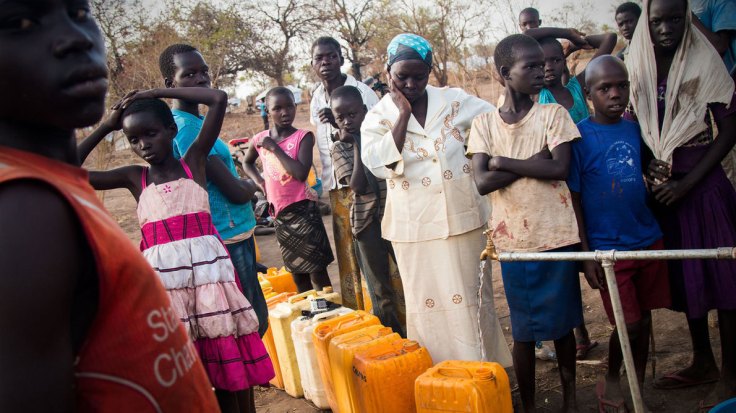
Hundreds of thousands of refugees have fled the civil war in South Sudan and resettled in Uganda. This 12-minute documentary shows the daily struggle to get water.

Source: www.npr.org

Next to nothing in this video will make you happy about the way things operate for refugees in Northern Uganda who have fled from South Sudan.  We all know the about the dire conditions that refugees face, but knowing about the specifics, and hearing stories from the refugees about their lives and living conditions is powerful.  A huge influx of refugees can tax local resources, especially water.  Food can be shipped in, but water a much more locally variable resource.   The UN refugee camps recommend at least 15 liters of water per person be made available each day, but often it is more like 4-8 liters in these camps.  Dedicated wells (or boreholes) are more effective, but costly.  Trucking in water from the Nile River is the preferred method to simply keep these drowning people’s heads above water.    

Questions to Ponder: Consider how much water you drink, use for cooking, bathing, etc. per day in your household.  How difficult would it be to live on 4 liters of water a day?  What about your lifestyle would be changed? 


Tags: Africa, development, Uganda, migrationrefugees, environment, water, sustainability, resources.

Mapping the human impact on the Great Lakes

“It’s no secret that the Great Lakes are suffering tremendous ecological strain — Lake Erie was even pronounced “dead” for a time during the 1960s because of an overload of phosphorus from municipal waste. Back in 1615, though, when the entire region was pristine and explorers Samuel de Champlain and Étienne Brûlé gazed out together from Lake Huron’s shores, they dubbed it la mer douce, ‘the sweet sea.’ Today roughly one-quarter of Canada’s population and a 10th of America’s population drink from the Great Lakes basin; the beleaguered lakes alone hold more than a fifth of Earth’s freshwater.”

Source: www.canadiangeographic.ca

Questions to Ponder: What watershed do you live in?  Where does your drinking water come from?  When you flush the toilet, where does it go? How are places in your watershed linked?  How does this similar map shed more light on these issues?  


TagsCanada, environment, resources, waterspatial, scale

Water Is Life

Hundreds of thousands of refugees have fled South Sudan to escape the civil war. When they arrive in Uganda, water is what they need most. Without it, they will die.

Source: www.youtube.com

Next to nothing in this video will make you happy about the way things operate for refugees in Northern Uganda who have fled from South Sudan.  We all know the about the dire conditions that refugees face, but knowing about the specifics, and hearing stories from the refugees about their lives and living conditions is powerful.  A huge influx of refugees can tax local resources, especially water.  Food can be shipped in, but water a much more locally variable resource.   The UN refugee camps recommend at least 15 liters of water per person be made available each day, but often it is more like 4-8 liters in these camps.  Dedicated wells (or boreholes) are more effective, but costly.  Trucking in water from the Nile River is the preferred method to simply keep these drowning people’s heads above water.    


Questions to Ponder: Consider how much water you drink, use for cooking, bathing, etc. per day in your household.  How difficult would it be to live on 4 liters of water a day?  What about your lifestyle would be changed? 


TagsAfrica, development, Uganda, South Sudan, migrationrefugees, environment, waterenvironment depend, sustainability, resources.

Senegal’s Great Green Wall combats desertification

“A 7,000 km barrier is being built along the footsteps of the Sahara to stop the desert expanding. The Great Green Wall project started in 2007 in Senegal, along with 10 countries in Africa to combat the effects of climate change. Al Jazeera’s Nicolas Haque reports from Widou, deep in the Sahel.”

Source: www.youtube.com

The Great Green Wall initiative is composed of 11 countries that are cooperating together to combat the physical and human geographic characteristics that make the Sahel one of the more vulnerable ecosystems in the world.  This swath running through Africa is the transition zone where tropical Africa meets the Sahara.  The Sahel is susceptible to drought, overgrazing, land degradation and desertification.  These issues of resource management and land use transcend international borders so this “Green Wall” was created with the intent to protect the environment, landscapes and people of the Sahel from desert encroachment (the shorter, social media friendly version of this video is available here).


Tags: Africa, Senegal, development, environment, waterbiogeography, ecology, environment depend, physical, weather and climate, supranationalism, political ecology.

As Climate Change Accelerates, Floating Cities Look Like Less of a Pipe Dream

A costly plan to build floating islands shows how climate change is pushing the search for innovative solutions, but some critics ask who will ultimately benefit.

Source: www.nytimes.com

As coastal communities are considering what the tangible impacts of climate change might be, things that were once considered science fiction could be a part of how people adapt to the modifications we’ve collectively made to our global environment that we depend on to sustain life.  


Tags: physicaltechnologysustainability, climate change, environment, resources, watercoastal, environment dependenvironment adapt, environment modify.

Creating RI’s Off-Shore Wind Farm

Today, to the southeast of Block Island, there are five new structures rising from the ocean. These are the towers of the Block Island Wind Farm (BIWF), the first offshore wind energy installation in the United States. The turbines will generate 30 megawatts of energy; providing electricity to 17,000 households on Block Island and coastal Rhode Island (McCann, 2016), and replacing the diesel generators that previously powered New Shoreham. The turbines are on schedule to begin turning in November 2016 once commissioning is complete.

Source: uri.maps.arcgis.com

One of the overriding, major take-home points of this ESRI StoryMap, is that a project of this scale, scope, and magnitude requires geographic data across many disciplines (to see the largest off-shore wind farm in the world, click here).


Tags: mapping, Rhode IslandESRIStoryMap, GISresources, water, coastalenergy, environment depend.

Climate Migrants

Climate change has already displaced tens of thousands of people. If it continues unabated, it could lead to one of the largest mass human migrations in history.

Source: storymaps.esri.com

This StoryMap shows some key regions where migrants are fleeing some of the negative impacts of climate change, a trend that appears very likely to increase in the future.  It is also an excellent example of the ESRI’s new Cascade template for creating a web app. 


Tags: physical, weather and climate, climate change, environment, resources, watercoastalmappingESRIStoryMap, visualization, environment depend, political ecology.

Surging Seas Interactive Map

Global warming has raised global sea level about 8″ since 1880, and the rate of rise is accelerating. Rising seas dramatically increase the odds of damaging floods from storm surges.

Source: sealevel.climatecentral.org

This interactive map from Climate Central dramatically shows what locations are most vulnerable to sea level rise.  You can adjust the map to display anywhere from 1 to 10 feet of sea level rise to compare the impact to coastal communities.  This dynamic map lets to view other layers to contextualize potential sea level rise by toggling on layers that include, population density, ethnicity, income, property and social vulnerability.   


Tags: physical, weather and climate, climate change, environment, resources, watercoastalmapping, visualization, environment depend, political ecology.

Drought Drains Lake Mead to Lowest Level

“The largest reservoir in the U.S. falls to its lowest water level in history, Nevada State Sen. Tick Segerblom introduced a bill title and issued a press release on July 8 calling for an ‘independent scientific and economic audit of the Bureau of Reclamation’s strategies for Colorado River management.'”

This week’s history-making, bad-news event at Lake Mead has already triggered lots of news stories, but almost all of these stories focus on the water supply for Las Vegas, Phoenix and California. But what about the health of the river itself?

Tags: physicalfluvial, drought, water, environment.

Source: ecowatch.com

Create a free website or blog at WordPress.com.

Up ↑