Search

GEOGRAPHY EDUCATION

Supporting geography educators everywhere with current digital resources.

Tag

images

Winners of the 2018 National Geographic Travel Photographer of the Year Contest

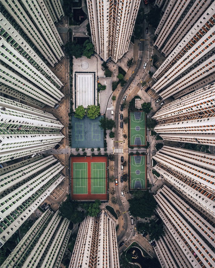
 "In this photo, I tried to bring the intense and stacked living conditions that Hong Kong is famous for into perspective for the viewer. With so many people living in small spaces, it’s strange to see all these amenities empty. As a solo traveler, I’m often alone in crowds and this photo resonates with me. I barely scratched the surface of this incredible urban environment, but this image really summarizes my experience here."

Source: www.theatlantic.com

The winning images have been selected from this year’s edition of the National Geographic Travel Photographer of the Year competition. This image, Alone in the Crowds by Gary Cummins, received honorable mention, in the category, Cities. There are many gorgeous images in here that–oh yeah– are also great teaching images.  If you want more, check out this additional gallery.

Scoop.it Tags: perspective, National Geographic, images.

WordPress TAGS: perspective, National Geographic, images.

Homeland of tea

“China is the world’s biggest tea producer, selling many varieties of tea leaves such as green tea, black tea, oolong tea, white tea and yellow tea. Different regions are famous for growing different types of tea. Hangzhou is famous for producing a type of green tea called Longjing or the Dragon Well tea. Tea tastes also vary regionally. Drinkers in Beijing tend to prefer jasmine tea while in Shanghai prefer green tea. Processing raw tea leaves for consumption is a time and labor-intensive activity and still done by hand in many areas in China. The Chinese tea industry employs around 80 million people as farmers, pickers and sales people. Tea pickers tend to be seasonal workers who migrate from all parts of the country during harvest time. In 2016, China produced 2.43 million tons of tea.”

Source: www.bostonglobe.com

Tea, the world’s most popular beverage, doesn’t just magically appear on kitchen tables–it’s production and consumption is shaped by geographic forces, cultural preferences, and regional variations.  These 21 images show the cultural, region, and environmental, economic, and agricultural context of tea.  


Tagsimages, foodChina, East Asia, economic, labor, food production, agriculture.

The American West, 150 Years Ago

In the 1860s and 70s, photographer Timothy O’Sullivan created some of the best-known images in American History. After covering the U.S. Civil War, (many of his photos appear in this earlier series), O’Sullivan joined a number of expeditions organized by the federal government to help document the new frontiers in the American West. The teams were composed of soldiers, scientists, artists, and photographers, and tasked with discovering the best ways to take advantage of the region’s untapped natural resources. O’Sullivan brought an amazing eye and work ethic, composing photographs that evoked the vastness of the West. He also documented the Native American population as well as the pioneers who were already altering the landscape. Above all, O’Sullivan captured — for the first time on film — the natural beauty of the American West in a way that would later influence Ansel Adams and thousands more photographers to come.


Tags: images, artlandscape, tourism, historicalUSA.

Source: www.theatlantic.com

25 Photos That Will Make You Fall in Love With Norway

“So how gorgeous is Norway? From its majestic wildlife, captivating Northern Lights shows, and snowy mountains, to its vivid landscapes, and mystifying fjords, Norway is a must-visit destination for anyone who loves the outdoors. Plus, opportunities for hiking, kayaking, glacier climbing, fishing, and skiing are endless! If Noway wasn’t already on your travel bucket list, I bet it is now!”

Source: www.travelalphas.com

My wife lived in Norway for 18 months, and her love for this country is infectious.  The stunning physical geography leads to some equally magnificent cultural landscapes that were forged in a very rugged, inhospitable environment for early human settlers.   


Tags: Norway, place, tourismphysical, Arctic, geo-inspiration, images, artlandscape.

Lights of Human Activity Shine in NASA’s Image of Earth at Night

NASA scientists have just released the first new global map of Earth at night since 2012. This nighttime look at our home planet, dubbed the Black Marble, provides researchers with a unique perspective of human activities around the globe. By studying Earth at night, researchers can investigate how cities expand, monitor light intensity to estimate energy use and economic activity, and aid in disaster response.

Source: www.youtube.com

NASA scientists are releasing new global maps of Earth at night, providing the clearest yet composite view of the patterns of human settlement across our planet.  You can download the image at a good resolution (8 MB jpg) or at a great resolution (266 MB jpg) to explore at your leisure.  


Tags: mapping, perspective, images, geospatial.

100 Great Teaching Images

“Nature and humankind are both great artists, and when they join forces, amazing masterpieces can be produced. Today Bright Side has collected for you works in which the combined efforts of mother nature and photographic artists have captured magic moments showing the wondrous diversity of modern life and the natural world. Pictured above is the Westerdok District in Amsterdam.”


Tags: images, artlandscape, worldwide.

Source: brightside.me

Iceland’s Glacial Melt and Geothermal Activity

Glacial melting and flooding occurs every year by the Skafta River in Iceland. As the water travels down towards the North Atlantic Ocean, incredible patterns are created on the hillsides. Rising lava, steam vents, or newly opened hot springs can all cause this rapid ice melt, leading to a sizable release of water that picks up sediment as it flows down from the glaciers.


Tags: geomorphology, physical, Europe, fluvial, water, landforms, images.

Source: www.instagram.com

27 stunning satellite images that will change how you see our world – Geoawesomeness

“The images come from the amazing book called “Overview: A New Perspective of Earth”. that just hit the stores around the world. The book is a stunning and unique collection of satellite images of Earth that offer an unexpected look at humanity, derived from the wildly popular Daily Overview Instagram account followed by almost 0.5 million people.”


Hagadera, seen here on the right, is the largest section of the Dadaab Refugee Camp in Northern Kenya and is home to 100,000 refugees. To cope with the growing number of displaced Somalis arriving at Dadaab, the UN has begun moving people into a new area called the LFO extension, seen here on the left. Dadaab is the largest refugee camp in the world with an estimated total population of 400,000.

Source: geoawesomeness.com

The most detailed 3D world model

“How to create a detailed 3D topographic model of the entire Earth? As you could suspect the only feasible way to do it is using satellites. But a regular satellite scan will not be detailed enough to give you a meter-level accuracy. Instead of using a single satellite they’ve launched to an orbit two satellites orbiting next to each other capturing stereoscopic scans of the surface of the Earth (that scan the same areas from slightly different angles). Now this data has been processed into a seamless 3-dimensional world map of unprecedented accuracy of 1 meter. The data and the press release are publicly available.”


Tags: geospatial, images, remote sensing.

Source: geoawesomeness.com

Create a free website or blog at WordPress.com.

Up ↑