Search

GEOGRAPHY EDUCATION

Supporting geography educators everywhere with current digital resources.

Tag

coastal

Beaches, Pollution, Governance, and Scale

Coronado Beach scene from the movie, “Top Gun: Maverick.” Point Loma peninsula in the background.
Local Area

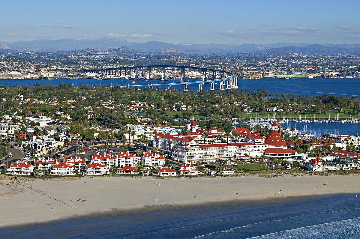
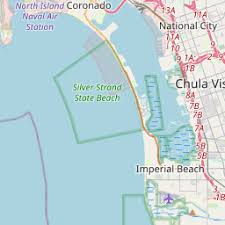
I was in the waves, enjoying the beach on my vacation to San Diego, when the importance of geographic scale to political governance hit me (I know, I’m a geography nerd…guilty).  Local, state, national, and international organizations administer laws and regulations over space, and there are going to be overlapping jurisdictions and different priorities at different scales.  I visited the two beaches I always went to as a kid, Coronado and Imperial Beach (IB).  These are the two most southern beaches in California, and Coronado is now famous for the Top Gun: Maverick beach scenes with Point Loma in the background.  Not surprisingly, tourism is incredibly important to these beach communities, especially in the summer.  As is often the case, this little case study shows how geographic topics and scales are interlinked on the ground (or in the water as it were). 

Imperial Beach is famous for it’s sandcastle festivals.

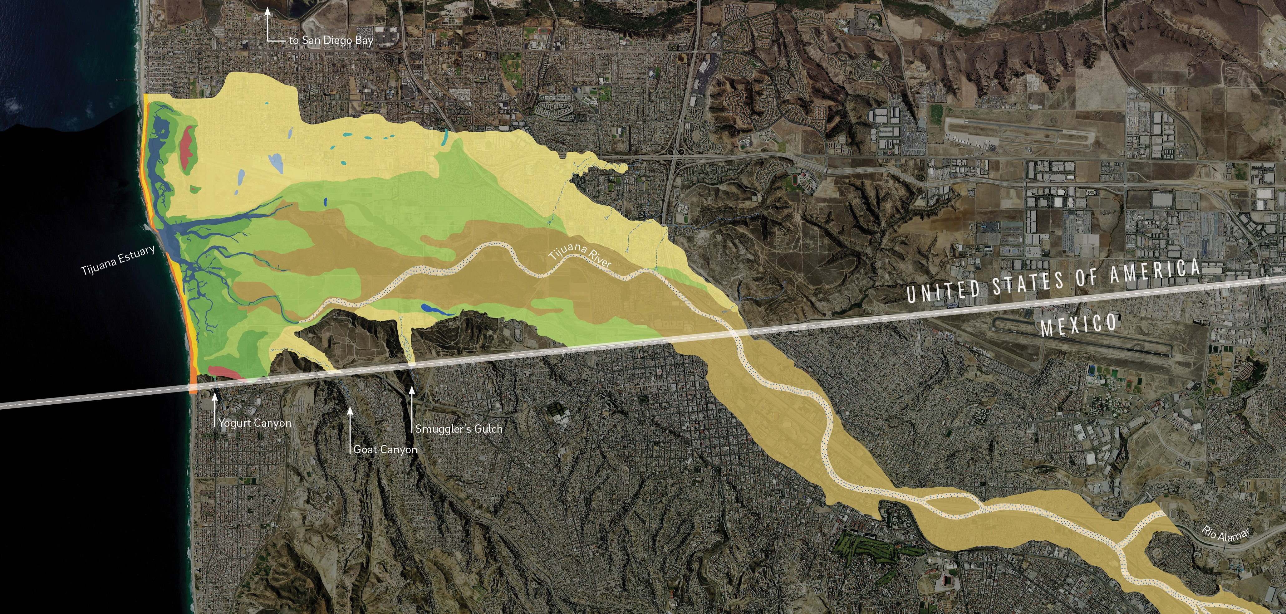
INTERNATIONAL CONTEXT: The Tijuana River flows through downtown Tijuana and crosses the U.S. border before emptying into the Pacific Ocean.  The river is heavily industrialized in Mexico with pollutants and sewage from the major urban area of Tijuana, but the river is treated as a wetlands wilderness preserve in the once it crosses into the United States (downstream of the pollutants).    

The Tijuana River cares not for international borders and differing regulations.

LOCAL (CITY) CONTEXT: The South Bay beach communities have built a summer economy around surfing, sandcastles, and chilling at the beach.  This municipalities generate a substantial portion of local revenue from the shops, restaurants, and businesses (Hotel Del Coronado is the most famous seaside venue here). 

COUNTY CONTEXT: In May, 2022, San Diego County changed their methods of testing water quality.  They implemented a DNA test to screen for bacteria in the water.  This test is more sensitive that the older tests and San Diego County is the only county in the U.S. using this heightened standard to measure water quality at the beach.      

PANDEMIC CONTEXT: Public health is more on the forefront of people’s radar and many agencies are more risk averse than individuals. 

SITUATION: The water at Imperial Beach, Silver Stand, and Coronado failed the new 2022 test more often than not even if it would have passed by the old standard.  May and early June, the beaches were closed over 50% of the time. San Diego County cities can’t control the Tijuana River much before it crosses back into the United States, so they are limited on options to clean up the river, but the Federal government though, through the EPA, announced in 2021 that a $300 million initiative in conjunction with the Mexican government.  This summer, Coronado has had to cancel large regional events and now the mayors, city councils, business leaders, and residents are pushing back against the new county testing procedures, citing economic damage to their communities. They have settled on a new advisory system that includes a comprise warning—one  where the state is acknowledging that the water is polluted (3% chance of getting sick), but that people who have been to these beaches for years can choose for themselves to swim or not.    

What is the right choice?  Depends on your priorities (maintaining the tourist economy or public health benefits?) and the scale at which you are looking at the situation. 

Tags: California, coastal, scale, environmental, political, pollution.

Hotel Del Coronado is both a landmark and a cash cow (featured in Marilyn Monroe’s “Some Like it Hot.”)

Damaged and defiant: Hurricane Harvey

Houston holds strong in the wake of devastation left by Hurricane Harvey.

Source: www.houstonchronicle.com

I am sharing these three interactive webmaps of Houston with my mapping courses to demonstrate what is technologically possible.  Texts, charts, pictures, videos, and maps can be seamlessly integrated to present spatial information in an incredibly engaging and accessible manner.  

Houston’s Hurricane Harvey was incredibly impactful but the factors leading to this were also very complex.  These three Story maps lay out:

  1. Houston’s urban ecological context
  2. The geographic origins of Hurricane Harvey
  3. The human stories from Hurricane Harvey


Scoop.it Tags:  physical, water, coastal, urban,  urban ecology, disasters, mapping, ESRI, StoryMap.

WordPress TAGS: physical, water, coastal, urban, urban ecology, disasters, mapping, esri, storymap.

Peru gives landlocked Bolivia a piece of Pacific coast to call its own

“It might be a strip of sand without even a jetty but a small stretch of the Pacific coast now harbors Bolivia’s dream of regaining a coast and becoming a maritime nation. The landlocked Andean country has won access to a desolate patch of Peru’s shoreline, fueling hopes that Bolivia will once again have a sea to call its own. President Evo Morales signed a deal yesterday with his Peruvian counterpart, Alan García, allowing Bolivia to build and operate a small port about 10 miles from Peru’s southern port of Ilo. The accord, sealed with declarations of South American brotherhood, was a diplomatic poke at Chile, the neighbor that seized Bolivia’s coast and a swath of Peruvian territory in the 1879-84 war of the Pacific.”

Source: www.theguardian.com

How important is a coastline to the economic viability of a country in the global market and to for the country’s geopolitical strengthen?  Ask the countries without one. 


Tags: South America, Bolivia, economic, transportation, political, coastal, borders.


Pacific nation Tuvalu has grown by 73 hectares over 40 years

“The tiny Pacific nation of Tuvalu – once thought to be under threat from rising sea levels – has grown the size of California’s Disneyland over the past 40 years. It’s mostly thanks to waves dumping extra sediment, sand and gravel on shore lines, according to research by Auckland University scientists. The study, published in the Nature Communications journal on Friday, was the first in-depth look at how much each of Tuvalu’s 101 islands have changed over the decades.”


Tags: Oceaniawatercoastal, environment, physical, geomorphology, erosiongeology, landforms.

Source: www.stuff.co.nz

Houston’s stories of Hurricane Harvey

“Blue and her team selected 45 stories, each plotted with ESRI’s ArcGIS software on a map of Greater Houston and tied to the exact location where it was first told. The resulting story map of Hurricane Harvey, ‘Damaged and Defiant: Houston Stories,’ was published in the Houston Chronicle in December. The map shows short narratives gathered by Chronicle staffers from people across the area — from Crosby to Kingwood to Katy — each a unique perspective on the storm; told together, they’re the collective account of a city that experienced one of the worst natural disasters in U.S. history.”

Source: news.rice.edu

These interlinked Houston story maps show some of the key elements of a good story map: 1) strong spatial analytical components, 2) a powerful narrative, 3) rich visuals, 4) solid cartography, and 5) well-sourced information.


Tags: fluvialwatercoastal, urban, disasters, physical, mappingESRIStoryMap.

Borders and the Arctic Ocean

The ice in the Arctic is disappearing. Melting Arctic ice means new economic opportunities: trade routes in the Arctic ocean, and access to natural resources. Because of this, the Arctic nations are now moving to expand their border claims. Russia has shown that it’s the most ambitious, using a potent combination of soft power and military buildup to advance its agenda. They’ve said the Arctic is rightfully theirs.

Source: www.youtube.com

This video is the second video in “Vox borders” series that is shaping up to be an excellent resources for geography educators.  This focus is on Svalbard and Russia’s designs within the Arctic, but this TestTube episode is a shorter version that emphasizes how receding summer ice is being seen as an economic opportunity for all maritime claims in the Arctic.  Canada, the U.S., Russia, and Denmark (Greenland) all are subtly expanding their maritime claims.


Questions to Ponder: How do borders impact the develop/preservation of the Arctic?  How should uninhabited lands and waters be administered politically?


Corinth Canal

“This photograph, taken by an astronaut aboard the International Space Station, shows the straight line of the Corinth Canal as it crosses a narrow isthmus between mainland Greece (right) and the Peloponnese Peninsula. The canal cuts through the narrowest part of the isthmus of Corinth. The goal was to save ships from the dangerous 700-kilometer voyage around the ragged coastline of the peninsula.”

Source: earthobservatory.nasa.gov

Questions to Ponder: What does the word Isthmus mean and how does this image help tell that story?  When did people start modifying Earth’s physical systems?  What factors do we need to consider when evaluating the impacts of human modifications to the environment?    


Tags: water, coastal, landformsGreece.

The Edge of the Plates

“Tomales Bay lies about 50 kilometers (30 miles) northwest of San Francisco, along the edges of two tectonic plates that are grinding past each other. The boundary between them is the San Andreas Fault, the famous rift that partitions California for hundreds of miles. To the west of the Bay is the Pacific plate; to the east is the North American plate. The rock on the western shore of the Bay is granite, an igneous rock that formed underground when molten material slowly cooled over time. On the opposite shore, the land is a mix of several types of marine sedimentary rocks. In Assembling California, John McPhee calls that side “a boneyard of exotica,” a mixture of rock of ‘such widespread provenance that it is quite literally a collection from the entire Pacific basin, or even half of the surface of the planet.'”


Tags: geomorphologyremote sensing, tectonics, geology, Californiacoastal, physical.

Source: earthobservatory.nasa.gov

How Clean is Narragansett Bay?

“The progress in Rhode Island toward clean water owes a lot to this federal law. Seeing urban rivers and the beaches and coves of the upper bay rediscovered as natural assets for wildlife and people to enjoy is one of the great successes of the Clean Water Act [of 1972].”

Source: www.rimonthly.com

This article from geographer Mary Grady shows a pleasant story in the human and environmental interaction.  The upper bay (that in-between place where the Providence River widens and becomes part of the Narragansett Bay) has been cleaned up and has ecologically been revitalized and is becoming an asset to the community again.  It is far from pristine, but it nice to read about encouraging signs on this front.  


Tags: watercoastal, Rhode Island.

Blog at WordPress.com.

Up ↑