Search

GEOGRAPHY EDUCATION

Supporting geography educators everywhere with current digital resources.

Tag

z best of 2016

America’s ‘Megaregions’ using Commuter Data

New maps use math to define the amorphous term.

Source: www.citylab.com

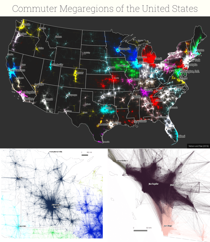
By now I’m sure many of you have seen some iteration of this research and data visualization circulating through social media outlets (you can see the article from City Lab, Atlas Obscura or an urban planning program).  We use terms like the greater metropolitan area to express the idea that areas beyond the city boundaries and even beyond the metropolitan statistical areas are linked with cities.  These ‘mega-regions’ are in part the hinterlands of a city, a functional region where the cities act as hubs of economic regions.   

Tags: regions, urban, transportationeconomicvisualization, mapping, USA, planning.

Map Men: teaching geography through comedy

Mark Cooper-Jones and Jay Foreman, the Map Men, tap into a rich vein of geographical quirks to teach through comedy

Source: geographical.co.uk

Why am I just now finding out about this resource?!?  This new YouTube channel is full of promise for geography teachers…fun, quirky, full of interesting trivia, but most importantly, these videos are rooted in geographic concepts. 


Tags: mappingfun, videoAPHG, geography education, unit 1 GeoPrinciples.

#GeoEdu16 Research from Routledge

As the proud publisher of both Journal of Geography and The Geography Teacher, the official publications of the National Council for Geographic Education, we couldn’t be more excited to join the NCGE in Tampa for #GeoEdu16. We will be offering NCGE members and attendees FREE ACCESS to specially selected content which reflects core themes of this special meeting: AP Human Geography, Race and Ethnicity, Climate Change and Human Migration, Coastal Geography, Geospatial Technology in the Classroom, Electoral Geography, and National Park Service!

Source: explore.tandfonline.com

The National Council for Geographic Education is having their 101th conference this week (#GeoEdu16).  The Journal of Geography and The Geography Teacher are fabulous resources produced by NCGE for geography educators (and great reasons to become a member of NCGE).  The recent APHG special edition is among the free downloads that will be available through the end of this year, so start downloading!  


Tags: NCGEAPHG, geography education, teacher training.

In stunning decision, Britain votes to leave the E.U.

The country opted to become the first ever to leave the 28-member bloc in a result that will send economic and political shockwaves across the globe.

Source: www.washingtonpost.com

The foundations of the European Union have their historical roots in World War II.  To ensure that European countries stop attacking each other, they knit their economies together and cooperated more on political and economic policies.   

The UK has narrowly voted to leave the European Union (52%-48%).  The Brexit (Britain + Exit) was expected to be close, but shows discontent with London.  The ‘Remain’ campaign dominated in London, Scotland and Northern Ireland while the ‘Leave’ campaign found its strength across England and Wales (see maps). 

The fallout of this vote is big and far-reaching.  The first global reaction was financial panic as numerous stock exchanges plummeted.  UK Prime Minister David Cameron will resign.  Already Spain is calling for joint control of Gibraltar (which they’ve wanted anyway) and using this as an opportunity to advance a Spanish agenda.  Many in Scotland chose to stay in the UK in part because they wanted Scotland to remain in the EU.  Another referendum on Scottish Independence feels eminent at this point.       

Still confused?  Here are answers to 9 frequently asked questions about the Brexit as well as a good overview from the Washington Post.


Tags: Europe, supranationalism, economic, political.

Where our food came from

“Explore the geographic origins of our food crops – where they were initially domesticated and evolved over time – and discover how important these ‘primary regions of diversity’ are to our current diets and agricultural production areas.”

Source: blog.ciat.cgiar.org

This is an incredibly rich website with great interactive maps, dynamic charts, and text with rich citations.  This is one of those resources that an entire class could use as a starting point to create 30+ distinct project.  This is definitely one of the most important and best resources that I’ve shared recently, one that I’m going to use in my class.  Where did a particular crop originally come from?  Where is it produced today?   How do these historic and current agricultural geographies change local diets and economies around the world?  All these issues can be explored with this interactive that includes, but goes beyond the Columbian Exchange


Tags: foodeconomicfood production, agribusiness, agriculture, APHG, unit 5 agriculture, globalizationbiogeography, ecology, diffusion.

Blog at WordPress.com.

Up ↑