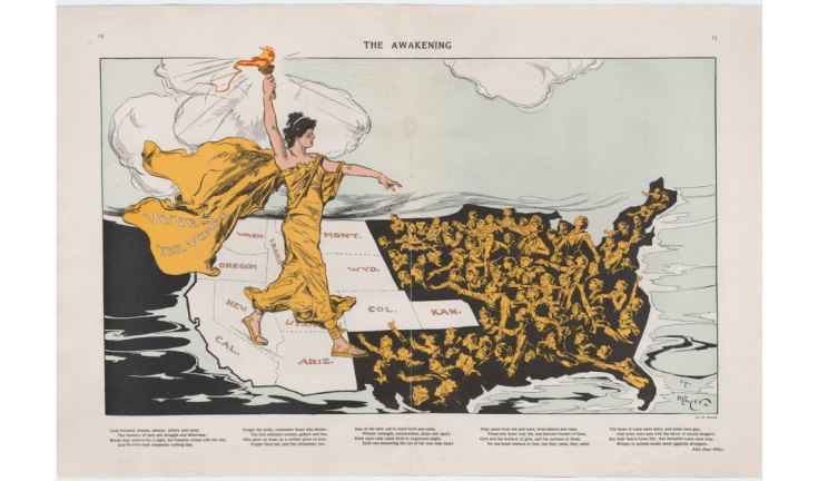
Search

GEOGRAPHY EDUCATION

Supporting geography educators everywhere with current digital resources.

Tag

art

Persuasive Maps

Awakening
The Awakening” was created by Henry Mayer in 1915. It is considered one of the most striking of the ‘suffrage maps,’ which played a major role in the successful fight for women’s suffrage in the U.S. 

This is a collection of ‘persuasive’ cartography: ​more than 800 ​ maps intended primarily to influence opinions or beliefs – to send a message – rather than to communicate geographic information. The collection reflects a variety of persuasive tools ​, including​ allegorical, satirical and pictorial mapping; selective inclusion; unusual use of projections, color, graphics and text; and intentional deception. Maps in the collection address a wide range of messages: religious, political, military, commercial, moral and social.” SOURCE: Cornell University Library

This is a fantastic collection of historical maps.  I especially enjoy the rhetorical and overtly persuasive quality of the maps in this collection.  Too often, we assume that maps convey data and information from a strictly neutral position.  Just like every news article, how the information in a map is arranged, selected, and framed is helpful in evaluating the usefulness, important, and accuracy of the information that is being presented.

GeoEd Tags: cartography, visualization, mapping, art.

The Man Behind Most of the Ski Maps in America

“The ski trail map at your local mountain was probably painted by James Niehues. Now you can see his life’s work in one beautiful book.”

Source: www.outsideonline.com

This new book looks to be a wonderful cartographic coffee table piece.  Good cartography lies at the intersection of rigorous scientific data display and an aesthetic touch of beauty. 

GeoEd Tags: cartography, visualization, mapping, art.

Scoop.it Tags: cartography, visualization, mapping, art.

The art of making globes

“In the era of Google Maps, who makes a living out of creating globes – by hand? Peter Bellerby, of Bellerby & Co. Globemakers, for one. Headquartered in London, he talks with Martha Teichner about how a desire to purchase a globe led to him becoming one of the masters of the craft.”

Source: www.youtube.com

Yes, these globes are precise archives filled with geospatial data and locational information–however, that pales in comparison to the artistic brilliance of the globes. These hand-crafted globes are truly works of art.  Marvel at the merger of mathematical precision and artistic design that makes a globe such as these a cartographic gem. 

FUTURE WATCHING: Here is the longer video of the Bellerby Globes being produced.     


Tags: cartography, visualization, mapping, artgeo-inspiration.

State Borders

Source: xkcd.com

I imagine most geographers have wanted to tinker with state or international borders to ‘fix them’ in one way or another…but if any ‘correction’ were to be made, whose criteria would be used?  Which people in which regions would be upset by the changes?  Historical inertia is a power force in maintaining the status quo. When France was preparing to consolidate it’s administrative regions, 68% recognized that consolidating regional administration would be more efficient but 77% didn’t want it to impact their own local region.


Tags: XKCD, art, mapping, cartography, borders, political.

The last globemakers

Peter Bellerby is one of the last artisan globemakers on earth. But now, he’s teaching an entirely new generation of artists the secrets of crafting entire worlds by hand.

Source: www.youtube.com

Yes, these globes are precise archives filled with geospatial data and locational information–however, that pales in comparison to the artistic brilliance of the globes. These hand-crafted globes are truly works of art.  Marvel at the merger of mathematical precision and artistic design that makes a globe such as these a cartographic gem.  If anybody want to get me a Christmas present, you know that I love cartographic gifts.  FUTURE WATCHING: Here is the longer video of the Bellerby Globes being produced.     


Tags: cartography, visualization, mapping, artgeo-inspiration.

The American West, 150 Years Ago

In the 1860s and 70s, photographer Timothy O’Sullivan created some of the best-known images in American History. After covering the U.S. Civil War, (many of his photos appear in this earlier series), O’Sullivan joined a number of expeditions organized by the federal government to help document the new frontiers in the American West. The teams were composed of soldiers, scientists, artists, and photographers, and tasked with discovering the best ways to take advantage of the region’s untapped natural resources. O’Sullivan brought an amazing eye and work ethic, composing photographs that evoked the vastness of the West. He also documented the Native American population as well as the pioneers who were already altering the landscape. Above all, O’Sullivan captured — for the first time on film — the natural beauty of the American West in a way that would later influence Ansel Adams and thousands more photographers to come.


Tags: images, artlandscape, tourism, historicalUSA.

Source: www.theatlantic.com

25 Photos That Will Make You Fall in Love With Norway

“So how gorgeous is Norway? From its majestic wildlife, captivating Northern Lights shows, and snowy mountains, to its vivid landscapes, and mystifying fjords, Norway is a must-visit destination for anyone who loves the outdoors. Plus, opportunities for hiking, kayaking, glacier climbing, fishing, and skiing are endless! If Noway wasn’t already on your travel bucket list, I bet it is now!”

Source: www.travelalphas.com

My wife lived in Norway for 18 months, and her love for this country is infectious.  The stunning physical geography leads to some equally magnificent cultural landscapes that were forged in a very rugged, inhospitable environment for early human settlers.   


Tags: Norway, place, tourismphysical, Arctic, geo-inspiration, images, artlandscape.

U.S.G.S. Topographical Maps

Think of them not as cartographic abstractions, but as incredibly affordable Pollocks.

Source: www.nytimes.com

Good cartography lies at the intersection of rigorous scientific data display and a aesthetic touch of beauty.  This article is an ode to the beauty of USGS topographic maps as affordable pieces of art.  Geography students that start their own mapping projects need to recognize that good cartographic work often needs to be both an art and a science to fit the needs of their intended audience. 


Tags: cartography, visualization, mapping, artgeo-inspiration.

Making Globes

“Colored printed sections showing the map of the world are cut to shape then pasted onto the surface of the globes and a protective coat of varnish is added. Narrator recounts the fact that lots of the workers have been there for over 30 years and quips: ‘While the rest of the mankind does its best to blow the world up, they like building a new one.'”

Source: www.youtube.com

I love watching globes made by hand and this vintage video shows the process of globes being made in London in 1955.  While most globe production is mechanized today, you can also watch the Bellerby company use gorgeous artistry to handcraft globes today.   


Tags: cartography, visualization, mapping, artgeo-inspiration.

Create a free website or blog at WordPress.com.

Up ↑