Search

GEOGRAPHY EDUCATION

Supporting geography educators everywhere with current digital resources.

Tag

STEM

These students make maps for the Philippines and Belize. They never leave campus to do it.

mapathon-1

With Queen’s ‘Bohemian Rhapsody’ humming in the background, about two dozen students at George Washington University traced skinny lines and square-shaped landmarks on a satellite image of a rural chunk of Mindanao, the second-largest island in the Philippines. They are in the early stages of piecing together a map of the region where half of the country’s food is grown but where most people live in poverty.

The students carefully scanned the photos to scope out buildings and roads tucked between thick trees. The task is painstaking but necessary to create an up-to-date map. This corner of the Philippines — like large swaths of the planet — does not have any recent digital maps.” SOURCE: Washington Post

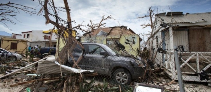
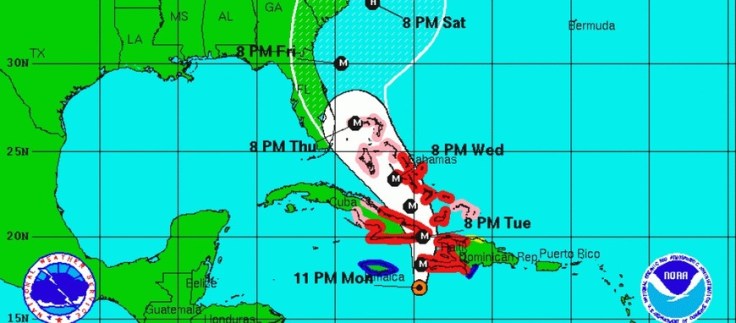
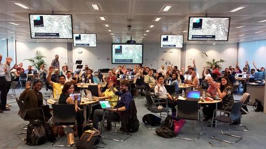
Crowd-sourced mapping is increasingly an important resource during an emergency and one of the best ways to put geographic knowledge and geospatial skills in action.  Many high school and college students around the country are learning mapping skills by creating maps for places that aren’t well-mapped and in great need.  Poorer places are often not as well mapped out by the commercial cartographic organizations and these are oftentimes the places that are most vulnerable to natural disasters.  Relief agencies depend on mapping platforms to handle the logistics of administering aid and assessing the extent of the damage and rely on these crowd-sourced data sets.  My students and I are working on this over the weekend; can you join in and help?  The projects that are marked urgent by the Red Cross are all in Haiti right now.  Here are is a video playlist that explains the project and how you can help if you are new to OpenStreetMap (OSM).  The embedded TEDx talk below discusses the advantages of using OSM in geography teaching.

GeoEd Tags: cartography, disasters, mapping, STEM.

Disaster Mapping: Hurricane Irma, Mexico Earthquake and Bangladesh Floods

This week has seen disasters and destruction on an unprecedented scale, and the HOT Community has activated to respond. Hurricane Irma is the largest Hurricane ever recorded, and has torn death and destruction through the Caribbean. Destruction on some islands is estimated at 95%, affecting the lives of 1.2 million so far, and on track to cause severe destruction across the entire Florida State, where mass evacuation is currently underway. Barbuda’s prime minister, Gaston Browne, described the damage as absolutely heart-wrenching. ‘The island is literally under water and barely habitable,’ Browne said. ‘About 95% of properties are damaged, there is a serious threat of disease. Additionally, those already affected by Irma fear a second brutal battering by Hurricane Jose.'”

Source: www.hotosm.org

Want to see geographic knowledge and geospatial skills in action?  Crowd-sourced mapping is increasingly an important resource during an emergency.  Poorer places are often not as well mapped out by the commercial cartographic organizations and these are oftentimes the places that are most vulnerable to natural disasters.  Relief agencies depend on mapping platforms to handle the logistics of administering aid and assessing the extent of the damage and rely on these crowd-sourced data sets.  My students and I join OpenStreetMap (OSM) projects, especially when there is a major humanitarian need…it’s a great way to make service learning and geospatial technologies come together. The projects that are marked urgent by the Red Cross are all in Haiti right now.  Here are is a video playlist that explains the project and how you can help if you are new to OpenStreetMap (OSM).


Tags: disasters, mapping, edtechSTEM, weather and climate.

The Geography Teacher’s Introduction to OpenStreetMap

“Wed, Mar 15, 2017 8:00 PM – 9:00 PM EDT, the NCGE will be offering a free webinar for educators on the OpenStreetMap project and how you can incorporate it into your class.”

Source: attendee.gotowebinar.com

My students and I join OpenStreetMap (OSM) projects, especially when there is a major humanitarian need…it’s a great way to make service learning and geospatial technologies come together. If you are interested learning more about OSM projects for the classroom, sign up for this NCGE webinar seminar as soon as possible, since this event is right around the corner (the webinar program is one of the many great reasons to become a member of NCGE). 


TagsNCGE, mappingedtech, cartography, geospatial, disasters, STEM.


How Eratosthenes calculated the Earth’s circumference

“In the mid-20th century we began launching satellites into space that would help us determine the exact circumference of the Earth: 40,030 km. But over 2000 years earlier, a man in Ancient Greece came up with nearly the exact same figure using just a stick and his brain.”

Source: www.youtube.com

Eratosthenes is often referred to as the “father of geography” for creating meridians and parallels on his maps to organize global information, classifying climatic zones, and as shown in the video, calculating the circumference of the Earth. Plus, he coined the terms so he gets the credit. If you have never pondered the meaning of the word “geometry,” the accomplishments of Eratosthenes will certainly show that the mathematical prowess was at the heart of expanding our collective geographic knowledge (additionally, here is a retro Carl Sagan in a video clip from Cosmos that inspired this clip).    


Tagsmapping, math, locationSTEM, historical.

Hurricane Matthew-Humanitarian Mapping

“The Humanitarian OpenSteetMap Team (HOT) has activated to provide geographic base data in areas affected by Hurricane Matthew. Category 4 Hurricane Matthew continues to strengthen and is advancing on Haiti and the Bahamas. Hurricane Matthew is expected to cause ‘catastrophic‘ damage including extreme flooding and landslides potentially affecting millions in Haiti, Jamaica, and Bahamas. To start we are mapping coastal communities in the storm path.”

Source: hotosm.org

Want to see geographic knowledge and geospatial skills in action?  Crowd-sourced mapping is increasingly an important resource during an emergency.  Poorer places are often not as well mapped out by the commercial cartographic organizations and these are oftentimes the places that are most vulnerable to natural disasters.  Relief agencies depend on mapping platforms to handle the logistics of administering aid and assessing the extent of the damage and rely on these crowd-sourced data sets.  My students and I are working on this over the weekend; can you join in and help?  The projects that are marked urgent by the Red Cross are all in Haiti right now.  Here are is a video playlist that explains the project and how you can help if you are new to OpenStreetMap (OSM).


Tags: disasters, mappingSTEM, physicalHaiti, weather and climate.

Blog at WordPress.com.

Up ↑