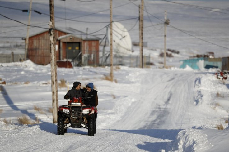
Search

GEOGRAPHY EDUCATION

Supporting geography educators everywhere with current digital resources.

Tag

indigenous

On the edge of America, census begins in a tiny Alaska town

Alaska

The first Americans to be counted in the 2020 census live in [Toksook Bay, Alaska], a tiny community of 661 on the edge of the American expanse. Their homes are huddled together in a windswept Bering Sea village, painted vivid lime green, purple or neon blue to help distinguish the signs of life from a frigid white winterscape that makes it hard to tell where the frozen sea ends and the village begins. Once the spring thaw hits, the town empties as many residents scatter for traditional hunting and fishing grounds, and the frozen ground that in January makes it easier to get around by March turns to marsh that’s difficult to traverse. The mail service is spotty and the internet connectivity unreliable, which makes door-to-door surveying important. For those reasons, they have to start early here.” SOURCE: AP News.

This article is a reminder that while we are on preparing for the constitutionally-mandated 2020 census (get ready for updated maps everyone!!), the census is tasked with counting everyone.  Some populations such as this indigenous village in Alaska are harder to count than others.

Questions to Ponder: What are other populations that might be under-represented in the census?  What would be measures that census employees could take to count those people?  How does the census improve our ability to understand geographic patterns?

GeoEd Tags: indigenous, census.

Masters of Tradition: A Cultural Journey Across America

NEA Map

Explore the Masters of Tradition story map. Discover the rich diversity of cultures and artistic traditions that enliven our nation. Meet extraordinary artists from across the country who have been awarded the National Endowment for the Arts National Heritage Fellowship, the nation’s highest honor for excellence in the folk and traditional arts. Together they represent a remarkable portrait of America’s diverse cultural heritage.” SOURCE: ESRI

This is an excellent StoryMap that to shows examples of local and indigenous cultures that are being practiced by some in the United States.  The NEA Fellowship also shows how preserving local and indigenous cultural traits in the face of popular cultural influences is difficult and is seen as a national priority and part of a treasured cultural heritage.  This is a good article on how to plan a good storymap.

Excellent Examples using the Map Tour template:

  1. Ancient Worlds of the World
  2. New Wonders of the World
  3. Visit Palm Springs
  4. A Gallery of other examples

GeoEd Tags: indigenous, culture, esri, storymap.


Iqaluit’s population turns to Amazon Prime

Sky-high food prices in the North have led many residents of Iqaluit to turn to Amazon Prime to save on necessities. But is that a sustainable solution?

Source: globalnews.ca

Nunavut is remote…far more remote than most of our students can imagine.  They live over 1,000 miles from any city with half a million people.  The entire territory is enormous, but sparsely populated with only 36,000 people.  Try to image getting commercial goods to such a remote location.  The Canadian government has invested heavily to subsidize systems to get food products and other necessities to Nunavut.  Still, the transportation costs are so high, and the numbers are so few that economies of scale can’t help this situation. 

Enter Amazon Prime in 2005, and the online retail giant began offering free shipping for “Prime” customers for a flat yearly subscription fee (today $99 in the U.S.).  This was simply too good to be true for many customers in far-flung settlements in Nunavut.  Amazon, probably not anticipating the overwhelming transportation costs associated with a place like Nunavut, in 2015 stopped offering Prime membership for Nunavut customers that do not live in the capital city of Iqaluit.  Still, the capital city looks to Amazon Prime more so than the Canadian or territorial government as their lifeline to the global economy.  Some even argue that Amazon Prime has done more to improve the standard of living  and providing food security for Nunavut residents than the government.            

Scoop.it TagsCanada, distanceindigenous, poverty, development, economicfood, food distribution, density.

WordPress TAGS: Canada, distance, indigenous, poverty, development, economic, food distribution, density.

Mexico is home to world’s largest pyramid

No one knows who constructed this pyramid 2,300 years ago. Cortés missed it when he invaded the pyramid’s hometown in 1519 and it wasn’t rediscovered until 1910. Today it stands as the largest monument ever constructed.

Source: www.youtube.com

10 years ago, about 30 miles outside of Veracruz, Mexico, I see a hill completely covered in vegetation.  I notice that the angle is rather uniform and that it appears to have distinct faces at right angles.  It dawns on my that I’m staring at an archeological site that has not been excavated and the Indiana Jones explorer in me is immediately fascinated.  Mexico is filled with sites of ancient civilizations that stir the imagination and this is one of those. 


TagsMexicoindigenous, folk cultures, culture, tourism.

Finding North America’s lost medieval city

Cahokia was North America’s biggest city—then it was completely abandoned. I went there to find out why.

Source: arstechnica.com

The earthen mounds of Cahokia on the flat flood plains must have been the most awe-inspiring demonstration of political power and economic wealth in its day.  Like so many other civilizations before them (and many more in the future?), Cahokia probably declined from too many environmental modifications that led to unforeseen consequences.


Tagsurban ecology, indigenousenvironment, environment modify, historical, North America.

The Dakota Access Pipeline Map

“Thousands of Native Americans and their allies have gathered on unceded Sioux land delimited by the 1851 Treaty of Fort Laramie to try and stand in the way of the “black snake” that could poison the Standing Rock Reservation’s water supply. Many have noted that the pipeline corridor was repositioned from its original route north of Bismarck after white citizens spoke up against the threat a spill would pose to their drinking water ― a threat duly recognized by the U.S. Army Corps of Engineers. Yet the Corps failed its federal mandate for meaningful consultation with the Standing Rock Tribe before signing off on a route that moved the pipeline to their doorstep.”

Source: www.huffingtonpost.com

Maps can tell truths, and maps can be used to obscure other truths. Creating a map, choosing what data to include (and exclude) is an inherently political act.  Maps have the power to convey geographic perspectives that might otherwise be muted.


Tags: industryconflict, economic, energy, resources, environmentindigenous, ecology.

The Worst Mistake in the History of the Human Race

“Forced to choose between limiting population or trying to increase food production, we chose the latter and ended up with starvation, warfare, and tyranny. Hunter-gatherers practiced the most successful and longest-lasting life style in human history. In contrast, we’re still struggling with the mess into which agriculture has tumbled us, and it’s unclear whether we can solve it.”

Source: discovermagazine.com

Jared Diamond wrote this highly controversial essay back in the 80’s and it still can elicit strong reactions from anthropologists, geographers, historians, and other scholars.  This is a good reading to give students during an agricultural unit.  This can get students to question many of the assumptions about humanity that they probably never knew they had (Diamond challenged the mainstream progressivist position).


Questions to Ponder: What is the progressivist view?  What were the negative impacts that early agriculture had on human health?  What social problems does Diamond attribute to agriculture?  What evidence would you present to argue against Diamond’s position?


Tagsagriculturefolk culturestechnologyindigenous.

Cahokia – why did North America’s largest city vanish?

Long before Columbus reached the Americas, Cahokia was the biggest, most cosmopolitan city north of Mexico. Yet by 1350 it had been deserted by its native inhabitants the Mississippians – and no one is sure why

Source: www.theguardian.com

This article is the eighth in the “Lost Cities” series (Babylon, Troy, Pompeii, Angkor, Fordlandia, etc.).  The earthen mounds of Cahokia on the flat flood plains must have been the most awe-inspiring demonstration of political power and economic wealth in its day.  Like so many other civilizations before them (and many more in the future?), Cahokia probably declined from too many environmental modifications that led to unforeseen consequences.


Tagsurban ecology, indigenousenvironment, environment modify, historical, North America.

Dakota Access Pipeline: What You Need to Know

Conflict between Native American protesters and private security personnel over construction of the Dakota Access Pipeline has turned violent. What is the Dakota Access Pipeline?


Tags: industryconflict, economic, energy, resources, environmentindigenous, ecology.

Source: blog.education.nationalgeographic.com

Blog at WordPress.com.

Up ↑