In this TED talk, global strategist, Parag Khanna explains how urbanization is reshaping economic and social geography, particularly in major regions like North America, South America, and Europe. Geography plays a key role in where megacities develop, often forming along coastlines, rivers, and transportation corridors that allow trade and movement of people. For example, cities like New York, São Paulo, and London grew because of their strategic access to waterways and global trade routes, which made them economic hubs. This connects directly to our textbook discussions of how physical geography influences settlement patterns, economic development, and cultural interaction. Additionally, Europe’s dense network of cities reflects its long history of trade and political fragmentation, while the Americas show patterns shaped by colonization, migration, and resource distribution. This TED Talk helps visualize how geographic location, transportation, and economic opportunity continue to shape regional development and globalization today, reinforcing the importance of spatial relationships in understanding regional geography.
Questions to Ponder:
Why do many of the largest cities develop near coastlines or rivers?
How does urbanization affect economic inequality between regions within the same country?
While I try to keep things nonpartisan, sometimes objective truths become partisan issues, and often the study of human geography can improve our collective political dialog. Department of Transportation, Pete Buttigieg (a.k.a. Mayor Pete) said “there is racism physically built into some of our highways.” Online detractors noted that rebar, concrete, and asphalt can’t be racist, etc. You see the over-literal interpretation, but I want to discuss his bigger point—how has racism shaped the building of infrastructure and urban landscapes?
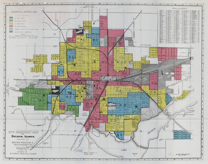
The term redlining has a specific definition and a broader application. First, the narrower definition; redlining was a historical practice in the early to mid-20th century where banks and other decision-makers used city maps that marked low-income neighborhoods (pre-dominantly African American), and would deny potential home-owners’ loans to purchase in these neighborhoods. In an era of legalized segregation, African Americans were in a bind; they could not move into the white neighborhoods, but they could not get loans to purchase a home in their own neighborhood. The maps literally used a red line to mark the neighborhoods where the banks would not provide any home-lending services to the residents. Explore this fantastic interactive map, Mapping Inequality: Redlining in New Deal America. You can use this to find redlining close to your home, or the city where I teach, Providence, RI.
1929 Home Owners Loan Corporation Map of Decatur, IL.
More broadly speaking, redlining is not just about the denial of home loans. Many practices such as this meant African Americans in the United States could not get access to the full range of services, utilities, resources, and planning to see improvements in their neighborhoods.
The era of redlining also coincided with the era of the private automobile and the beginning of large freeways on the American landscape. The major freeways in urban centers weren’t placed on conveniently open spaces, but by tearing down (typically) poor neighborhoods that had less of a political voice. This happened in African American neighborhoods in Baltimore, Oakland, New York, Detroit, Cincinnati…the list is far too long. Read this piece in the Guardian for some images and examples.
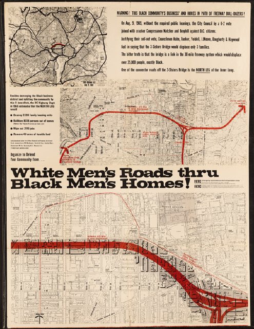
A poster against the creation of proposed highway in Washington DC. Source: DC History
So, when Mayor Pete says that “there is racism physically built into some of our highways,” he means it, and it’s a part of our historical geography. The road itself might not be racist, but the institutions that plowed through poor Black neighborhoods is, and leaves a legacy on the built environment. Redlining is obviously illegal today, but the neighborhoods they shaped, divided by railroad tracks or highways or both, these communities are still impacted by the policies of yesteryear.
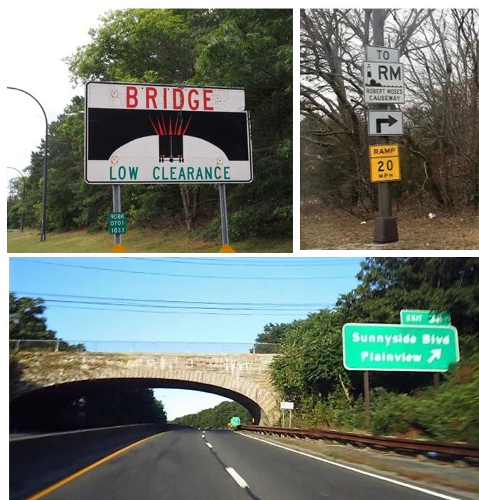
For generations, New York City urbanists have adored Jane Jacobs as the champion for local communities and her opposition to the soulless, neighborhood-destroying urban planner, Robert Moses. This is partially true, if simplistic, because hating one individual (Robert Moses) for inserting oppressive elements into the landscape misses the bigger point that he was simply in charge of the system, and if it weren’t for him, there would have been another to take his place. Let’s use one famous NYC, Robert Moses example of racism in the built landscape:
Images from Long Island, showing bridge overpasses that limit public transportation to beaches.
Action: Robert Moses designed Long Island bridges and highways with low overpasses.
Result: Long Island beaches are inaccessible through mass transit.
Purpose: Limit access of NYC poor from the affluent beaches of Long Island.
What are the implications of these facts? One instance of this type of infrastructural planning might be a coincidence rather than a sign of racial bias, or class-based bias, but the preponderance of evidence across the country from this era leads to the obvious conclusion that U.S. infrastructure, especially the highways, were shaped by racist policies that continue to have racial impacts. The evidence is there; for any honest observer, the conclusion that racism shaped U.S. infrastructure is not controversial.
Examine examples in your own community to see how these practices have shaped your local neighborhoods. Once you’ve seen how your community has been shaped, look at at other examples across the U.S. to see that your neighborhood is a part of a broader spatial pattern that shows how racism has shaped U.S. infrastructure.
“As winter approaches each year, a haze of toxic smog envelopes vast swaths of northern India, including the capital New Delhi, forcing authorities to shut schools and restrict the use of private vehicles. Unlike southern parts of the country, most arid regions of northern India, including New Delhi, struggle with dust, a common air pollutant. Environmental experts say New Delhi’s topography hobbles efforts by authorities to stave off the spike in pollution. In recent years, the problem has been exacerbated by the burning of crop residues in Punjab and Haryana states, part of the farm belt that borders New Delhi. Relatively prosperous farmers from Punjab and Haryana, India’s grain bowl, have started using mechanised harvesters to gather the rice crop, partly to overcome the problem of rising labour costs.” SOURCE: Al Jazeera
Mexico City has a reputation for horrible air pollution–and rightfully so–but Delhi’s air pollution is worse and this year it is off the charts. Much of India faces air pollution problems, but northern India, and especially Delhi sees the convergence of urban, agricultural, demographic, and environmental factors to exacerbate the problems. Geographic problems are often intertwined and is a good issue to use a S.P.E.E.D. or E.S.P.N. activity.
Walkable cities improve the local economy and many cities are working to improve their walkability. Cities can improve sidewalks, decrease parking lots, beautify storefronts and add other amenities that encourage walking. Neighborhoods that are very walkable often have a vibrant sense of place. This article (and the embedded video) nicely explain many issues surrounding walkable urban environments.
"In so many ways, Seattle is an amazing success story, thriving and economically vibrant, drawing thousands of people from around the country and the world. But we’ve also paid a hefty price for our success. The sudden injection of tech wealth has made Seattle a more exclusive place. It’s exacerbated inequalities, pushing people out of the city or even into homelessness. Rapid growth has taxed our infrastructure, and the debate over where to house all these new people has divided the city."
Here are three articles from West Coast cities (Seattle, San Francisco, and San Diego) all bemoaning the troubles/difficulties associated with the increasingly expensive housing markets that are negatively impacting the quality of life and the communities. The three cities in question are all perceived as highly desirable places to live and many creative industries and businesses are flourishing in these areas.
Rapid economic success will change a city–and reconfigure the spatial networks and the sense of place in many neighborhoods. As demand for new housing in exclusive neighborhoods grows, gentrification is but one of the processes that will impact the city. These are some of the most economically successful cities on the West Coast; but economic success for a region will also present new difficulties and challenges as many domestic and international migrants are attracted to these comes the areas. Virtually all of the cities that migrants are being pulled to for economic opportunities and cultural amenities are going to be experiencing some similar struggles.
"Old settlement patterns have reversed, but old problems of adaptation remain. Immigrants still like to settle where immigrants have already settled (chain migration). Once word of the new ethnoburbs got around, they grew fast. Letters, phone calls, and then emails back to the old country, enticed others. In Richmond, one group held an extended debate with city hall over there being ‘too much’ Chinese writing on business signs. Residents of a condo building complained when the strata council held its meetings only in Mandarin. And just as in other parts of gateway cities, as wealthy Chinese buy properties in ethnoburbs, they have been blamed for driving prices out of local reach."
Residents of ethnoburbs often have transnational lives that fit into their countries of origin as well as their new homes. Ethnoburbs are common in North America as well as Australia and New Zealand.
Questions to Ponder: What similarities and differences do ethnoburbs have from other ethnic communities? What similarities and differences do ethnoburbs have with other urban processes such as gentrification?
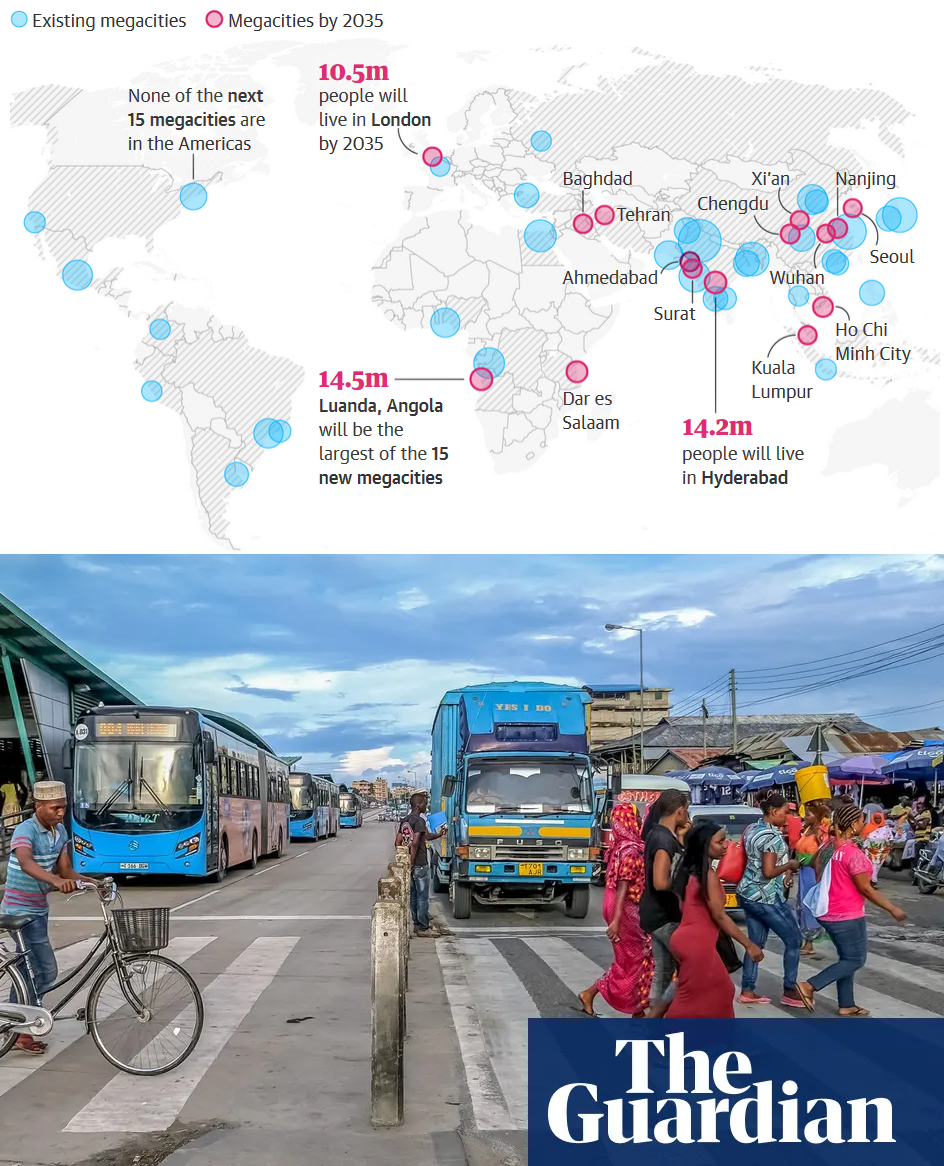
The next 15 megacities #2: Could Dar es Salaam’s experiment with Africa’s first ‘gold standard’ bus rapid transit system offer an alternative to a future dependent on private cars?
This is a good article about the critical nature of transportation infrastructure to a growing city in the developing world. More important than this one article, I want to highlight the entire Guardian series entitled "The Next 15 Megacities."
In 1975 there were only 3 megacities (cities population over 10 million) in the world. Today there are 33 megacities and by 2035, there are expected to be 48. This acceleration is one of the more astounding and important facts about how the world is changing today. This series explores these emerging megacities that will have over 10 million by 2035; overwhelmingly these cities are in Asia.
"Investing in walkable cities, whether through allocating funds to repaint pedestrian walkways or building affordable housing close to downtowns, also attracts diverse populations and creates jobs. According to the Chicago Metropolitan Agency for Planning, 63 percent of millennials and 42 percent of boomers would like to live in a place where they don’t need a car. And according to the National Association of Realtors, 62 percent of millennials prefer to live in a walkable community where a car is optional. If cities seem less automobile-dependent, chances are they are more appealing to a range of ages."
Walkable cities improve the local economy and many cities are working to improve their walkability. Cities can improve sidewalks, decrease parking lots, beautify storefronts and add other amenities that encourage walking. Neighborhoods that are very walkable often have a vibrant sense of place. This article (and the embedded video) nicely explain many issues surrounding walkable urban environments.
Hong Kong is the most expensive housing market in the world. It has been ranked as the least affordable housing market on Earth for eight years in a row, and the price per square foot seems to be only going up. The inflated prices are forcing Hongkongers to squeeze into unconventionally small spaces that can affect their quality of life.
Land scarcity is usually the main culprit behind extremely high real estate markets in the world’s most expensive housing markets. Silicon Valley, New York City, and other urban areas that are magnets for a young, well-educated workforce have very high costs of living. The rising property values and rents make living in a city on the rise difficult for many of the residents that aren’t a part of the economic rising tide (gentrification is just particular example).
Hong Kong is a very peculiar example were land scarcity is only a part of the situation. Bad land use (3.7% zoned for high density housing) policy and land management are bigger culprits. The government essentially owns all the land in Hong Kong and leases it to developers, so developers are incentivized to drive up that rates, given that the government doesn’t want to tax the corporations for the land that they occupy.
Season 2 of Vox borders has 5 episodes about Hong Kong: