Search

GEOGRAPHY EDUCATION

Supporting geography educators everywhere with current digital resources.

Tag

North Korea

Inside North Korea’s bubble in Japan

"Why North Korea has children’s schools in Japan. This isn’t a story about a physical border. North Koreans living in Japan experience a much less visible kind of border, one made of culture, tradition, history, and ideology. The result is a North Korean bubble in Japan whose members face fierce discrimination from Japanese society, leading the community to turn to Pyongyang for support. Now that community is being tested like never before. North Korea routinely threatens to destroy Japan with nuclear weapons, prompting a spike in Japanese nationalism. Japanese politicians are feeling increasing pressure to crack down on this North Korean bubble, creating a battleground in the most unlikely of places: schools."

Source: www.youtube.com

This episode of Vox borders offers some excellent insight into a cultural enclave that feels deeply connected with a totalitarian regime.  From the outside, this raises so many questions, but understanding the cultural, historical, political, and economic context shows how this peculiar community continues.  The entire series of Vox Borders is fantastic material, dripping with geographic content.   

Tags: North Korea, Japan, East Asia, borders, political, historical.

WordPress TAGS: North Korea, Japan, East Asia, borders, political, historical.
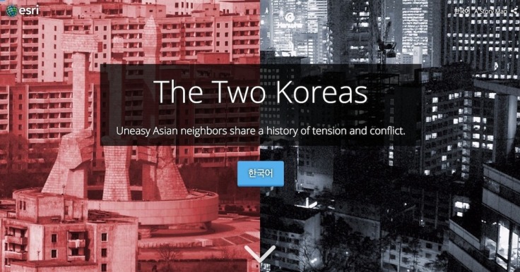
The Two Koreas

“While the Korean War of the early 1950s never formally ended, its aftermath has created starkly divergent worlds for those living on either side of the north-south divide. What follows is a look at life in the two Koreas; how such a night-and-day difference came to be; and where the crisis could go from here. Both governments claimed to be the legitimate rulers of the peninsula. Tensions between north and south gradually mounted, until finally, in June 1950, hundreds of thousands of North Korean troops stormed across the 38th parallel. The unsuspecting South Korean defenders were outgunned and outnumbered, and beat a hasty retreat southward.”

Source: storymaps.esri.com

This excellent interactive was created by Esri’s Story Maps team using the Story Map Cascade app–making it an great resources of the geography of the Korean Peninsula as well as a stellar example of how maps, infographics, videos, images and text can be combined using ArcGIS online.


Tags: mappingESRIStoryMapinfographic, visualizationNorth KoreaSouth Korea, East Asiaborders, political, geopolitics, historical.

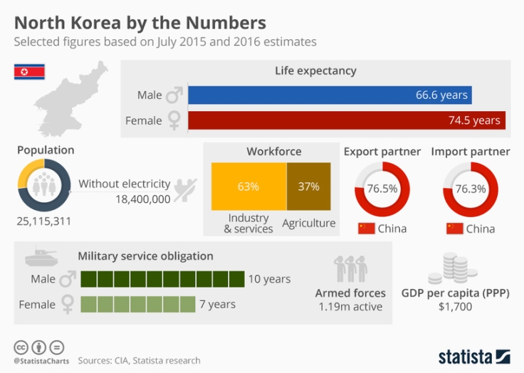
Infographic: North Korea by the Numbers

North Korea – a country hard to illustrate by numbers and those available are based on estimates. Accordingly, this graphic intends to give an overview on relevant aspects of a country hardly known by outsiders. Overall, we know little about the isolated northern part of the Korean peninsula and what we know is mostly disturbing: The DPRK’s government headed by Kim Jong-un has recently launched another missile test, adding up to 14 tests only in 2017.

Besides that, the country is estimated to be among the most militarised on the globe with more than a million active soldiers and an air force counting 944 aircrafts in total. Thus, North Korea is ranked 23rd (out of 133 countries) for military spending which approximately amounts to $7.5 billion per year. According to the CIA, young adults are obliged to spend several years in the military service, women around seven and men even ten years.

But above all, North Korea is a country that is desperately poor. Out of an estimated 25,115,311 inhabitants, only 36 percent of the population has access to electricity and the GDP per capita amounts to $1,700 – similar to that of South Sudan.


TagsNorth Korea, infographic.

Source: www.statista.com

Create a free website or blog at WordPress.com.

Up ↑