Search

GEOGRAPHY EDUCATION

Supporting geography educators everywhere with current digital resources.

Tag

race

How Has Racism Shaped U.S. Infrastructure?

While I try to keep things nonpartisan, sometimes objective truths become partisan issues, and often the study of human geography can improve our collective political dialog. Department of Transportation, Pete Buttigieg (a.k.a. Mayor Pete) said “there is racism physically built into some of our highways.” Online detractors noted that rebar, concrete, and asphalt can’t be racist, etc. You see the over-literal interpretation, but I want to discuss his bigger point—how has racism shaped the building of infrastructure and urban landscapes?    

The term redlining has a specific definition and a broader application. First, the narrower definition; redlining was a historical practice in the early to mid-20th century where banks and other decision-makers used city maps that marked low-income neighborhoods (pre-dominantly African American), and would deny potential home-owners’ loans to purchase in these neighborhoods.  In an era of legalized segregation, African Americans were in a bind; they could not move into the white neighborhoods, but they could not get loans to purchase a home in their own neighborhood.  The maps literally used a red line to mark the neighborhoods where the banks would not provide any home-lending services to the residents.  Explore this fantastic interactive map, Mapping Inequality: Redlining in New Deal America. You can use this to find redlining close to your home, or the city where I teach, Providence, RI.

1929 Home Owners Loan Corporation Map of Decatur, IL.

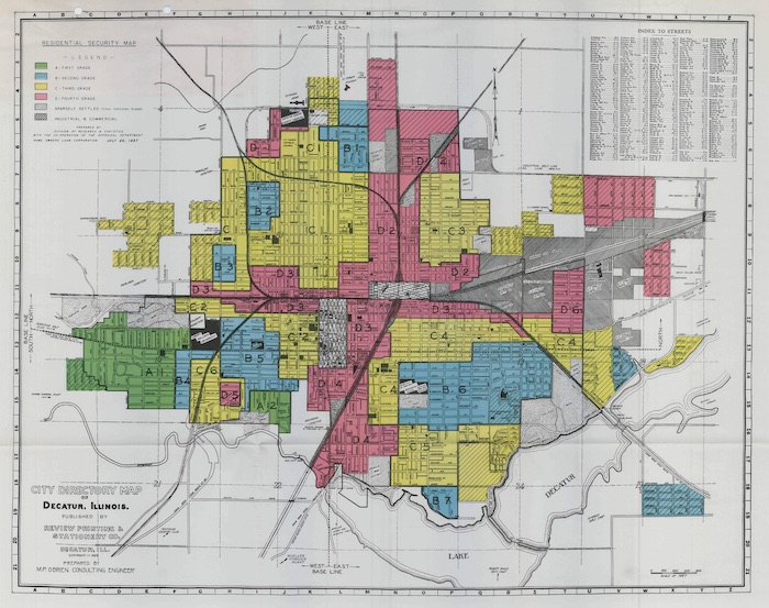
More broadly speaking, redlining is not just about the denial of home loans.  Many practices such as this meant African Americans in the United States could not get access to the full range of services, utilities, resources, and planning to see improvements in their neighborhoods.    

The era of redlining also coincided with the era of the private automobile and the beginning of large freeways on the American landscape.  The major freeways in urban centers weren’t placed on conveniently open spaces, but by tearing down (typically) poor neighborhoods that had less of a political voice. This happened in African American neighborhoods in Baltimore, Oakland, New York, Detroit, Cincinnati…the list is far too long. Read this piece in the Guardian for some images and examples.

A poster against the creation of proposed highway in Washington DC. Source: DC History

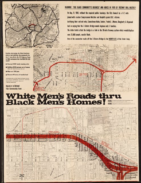
So, when Mayor Pete says that “there is racism physically built into some of our highways,” he means it, and it’s a part of our historical geography.  The road itself might not be racist, but the institutions that plowed through poor Black neighborhoods is, and leaves a legacy on the built environment.  Redlining is obviously illegal today, but the neighborhoods they shaped, divided by railroad tracks or highways or both, these communities are still impacted by the policies of yesteryear.        

For generations, New York City urbanists have adored Jane Jacobs as the champion for local communities and her opposition to the soulless, neighborhood-destroying urban planner, Robert Moses.  This is partially true, if simplistic, because hating one individual (Robert Moses) for inserting oppressive elements into the landscape misses the bigger point that he was simply in charge of the system, and if it weren’t for him, there would have been another to take his place.  Let’s use one famous NYC, Robert Moses example of racism in the built landscape:

Images from Long Island, showing bridge overpasses that limit public transportation to beaches.
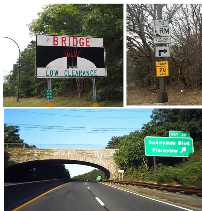
  • Action: Robert Moses designed Long Island bridges and highways with low overpasses.
  • Result: Long Island beaches are inaccessible through mass transit.
  • Purpose: Limit access of NYC poor from the affluent beaches of Long Island.

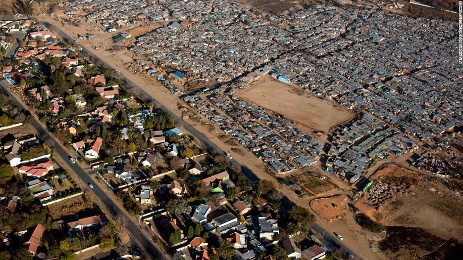
What are the implications of these facts?  One instance of this type of infrastructural planning might be a coincidence rather than a sign of racial bias, or class-based bias, but the preponderance of evidence across the country from this era leads to the obvious conclusion that U.S. infrastructure, especially the highways, were shaped by racist policies that continue to have racial impacts.  The evidence is there; for any honest observer, the conclusion that racism shaped U.S. infrastructure is not controversial. 

Examine examples in your own community to see how these practices have shaped your local neighborhoods. Once you’ve seen how your community has been shaped, look at at other examples across the U.S. to see that your neighborhood is a part of a broader spatial pattern that shows how racism has shaped U.S. infrastructure.

GeoEd Tags: race, landscape, urban, political, USA.

South Africa is the world’s most unequal nation

“Despite 25 years of democracy, South Africa remains the most economically unequal country in the world, according to the World Bank. If anything, South Africa is even more divided now than it was in 1994 as the legacy of apartheid endures. Previously disadvantaged South Africans hold fewer assets, have fewer skills, earn lower wages, and are still more likely to be unemployed, a 2018 World Bank report on poverty and inequality in South Africa found.”

Source: edition.cnn.com

This CNN article takes a shocked tone, but that removes South Africa from it’s historical and geographic context even if the outcome is unfortunate (as a bonus for educators, the article has a GINI reference in its analysis with the data charts).  Time’s cover story is more detailed and nuanced.  In the late 1980s, the apartheid system was becoming untenable; the injustices and discontent make the apartheid government unable to govern.  Both the government and activists recognized that change was necessary and compromises were needed to allow South Africa to move from the apartheid system of racial separation to nonracial democracy without falling apart.

The post-apartheid government guaranteed that while political power would be transferred, economic power would still stay ensconced in the hands of the land-owning elites, since there was to be no massive land redistribution. Neighboring Zimbabwe had disastrous land redistribution attempts and everyone wants to avoid economic chaos.  Land reform will be be a key issue in tomorrow’s election (see this BBC article for more election issues).     

GeoEd Tags: South Africa, Africa, race, ethnicity, political, economic.

Scoop.it Tags: South Africa, Africarace, ethnicitypolitical, economic

Why does the misperception that slavery only happened in the southern United States exist?

//cdn.embedly.com/widgets/media.html?src=https%3A%2F%2Fplayer.vimeo.com%2Fvideo%2F217064279&dntp=1&wmode=opaque&src_secure=1&url=https%3A%2F%2Fvimeo.com%2F217064279&image=https%3A%2F%2Fi.vimeocdn.com%2Fvideo%2F636139782_1280.jpg&key=25394e42b38f11e0ae3f4040d3dc5c07&type=text%2Fhtml&schema=vimeo

“Christy Clark-Pujara research focuses on the experiences of black people in British and French North America in the seventeenth, eighteenth and early nineteenth centuries. She examines how the business of slavery—the buying and selling of people, food, and goods—shaped the experience of slavery, the process of emancipation, and the realities of black freedom in Rhode Island from the colonial period through the American Civil War.”

Source: vimeo.com

This is one of the many videos produced by the Choices Program about slavery in the New England (especially Rhode Island).  Featured in the videos is Dr. Christy Clark-Pujara, who wrote “Dark Work: The Business of Slavery in Rhode Island.”  There is a reason to what we learn in history, and there are also reasons to the histories that are rarely told.  More than any other of the original thirteen colonies and states along the Eastern Seaboard, Rhode Island plied the triangle trade transporting more slaves to the Americas than all the other states combined.


Some Rhode Island slavery facts:

  • In 1776, Rhode Island had the largest proportion of slave population of any of the New England colonies.
  • During the antebellum period Rhode Islanders were the leading producers of “negro cloth,” a coarse wool-cotton material made especially for enslaved blacks in the American South.
  • More than 60 percent of all the slave ships that left North America left from Rhode Island.


Tags: raceRhode Island, slavery, labor, economic, historical.

Map: Where Are Confederate-Named Schools?

Most schools with names tied to the Confederacy are in the South, were built or named after 1950, and have a student body that is majority non-white.

Source: www.edweek.org

The maps (and the charts) created from this national database is quite revealing.  At least 36 ‘Confederate-themed’ schools have changed their names since 2015 and I suspect that number will continue to grow in the coming years.    


Tags: race, racism, landscape, historicalthe South.

South Africa Is Still Under Apartheid

“More than two decades after the end of apartheid in South Africa, Cape Town remains racially segregated, with many black residents living in substandard townships.”

Source: www.youtube.com

The title is a bit inflammatory–news agencies may pretend that they aren’t in the shock-and-awe, clickbait economy, but they invented the salacious headline to grab our attention.  Still, the racial inequities of a system as pervasive as apartheid aren’t going to be reversed in a generation and the racial differences in Capetown are coming under more international scrutiny as the they are in the midst of their current drought.


Tags: South Africa, Africarace, ethnicityneighborhood, urban, planning, drought, water, urban ecology.   

National Geographic Reckons With Its Past: ‘For Decades, Our Coverage Was Racist’

“Before it could publish an issue on race, the magazine first had to look at its own history. ‘Some of what you find in our archives leaves you speechless,’ writes editor Susan Goldberg.  The 1916 caption of the picture of these aboriginal Australians described them as ‘savages who rank lowest in intelligence of all human beings.'”

Source: www.npr.org

This is both incredibly obvious, and remarkably shocking.  I don’t think that any academic geographic should be surprised that for generations, National Geographic’s goals to describe the world’s people and it mission to sell magazines made its coverage a product of the cultural norms of the times, the magazine producers and subscribers.  Still, this open honesty coming from National Geographic about National Geographic’s past is a breath of fresh air that is quite encouraging, even if some still think that National Geographic’s issue and cover miss the mark.

Questions to Ponder: Are there some voyeuristic tendencies we might exhibit as well learn about, or discuss other cultures?  How do we highlight culture differences without making making those with different cultural practices seem as innately ‘other’ or ‘less than?’    

Tags: National Geographic, race, racismmedia

Whose Heritage? Public Symbols of the Confederacy

“In [recent years], the South’s 150-year reverence for the Confederacy was shaken. Public officials responded to the national mourning and outcry by removing prominent public displays of its most recognizable symbol [the flag]. It became a moment of deep reflection for a region where the Confederate flag is viewed by many white Southerners as an emblem of their heritage and regional pride despite its association with slavery, Jim Crow and the violent resistance to the civil rights movement in the 1950s and 1960s.”

Source: www.splcenter.org

Just a few more links that I’ve added to the article, Cultural Meaning in Moving Monuments.  Right now, many people are calling for the removal of all memorials that honor the Confederacy and the call for the removal of all Confederate monuments is in full swing.  


Tags: monuments, the South, architectureracecultural norms, landscape.

The dim reality of South Africa’s new dawn

In April 1994, South Africa held its first democratic elections and all races went to the polls to bury apartheid for good. But hopes of a new dawn have been tarnished by fraud and corruption at the highest levels.

Source: www.youtube.com

The first 2 and a half minutes of this video are a good historical analysis into the dismantling of apartheid in South Africa, culminating in the election of Nelson Mandela and the empowerment of the ANC.  Today though, the ANC and South Africa is mired in endemic corruption.  South Africa is one of the most unequal societies with high unemployment and a faltering economy. 


Tags: South Africacrime, Africa, political, racegovernance, ethnicity.

Gullah Culture

“While Gullah was not originally a written language and has never had a governing authority or dictionary, linguistic scholars have found that the language is internally consistent and in some ways more efficient and expressive than standard English. Elements of the language have seeped into African-American Vernacular English across the country.”


For the first time in recent memory, the Charleston County School Board is discussing how to address the specific needs of Gullah and Geechee students, children of a culture whose linguistic origins trace back to the west coast of Africa via the trans-Atlantic slave trade. Some teachers have said the students’ way of speaking — whether in the heavily West African-influenced Gullah language or in the more Anglicized dialects sometimes known as Geechee — can present an obstacle to understanding in the classroom. Like many Lowcountry Gullah speakers of her generation, the current head of state for the Gullah/Geechee Nation carries painful memories of adults who taught her to hold her family’s way of speaking in contempt.


Tags: language, culture, raceeducation, historical.

Source: www.youtube.com

Blog at WordPress.com.

Up ↑