Search

GEOGRAPHY EDUCATION

Supporting geography educators everywhere with current digital resources.

Month

November 2012

Generate Simple World Maps

RIC Study Abroad-Labeled

Free travel tip and photos from all over the world…

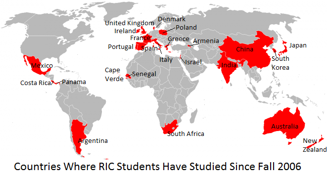
This map is not a professionally produced map and that is the beauty of this website. Virtually anyone can make a 1-feature world map by simply clicking on a checklist all of the countries you want highlighted on your map. Second, open the file and add some text and a few lines to label it. This took less than 20 minutes to make with no need for any cartographic or GIS experience.

See on www.traveltip.org

NASA – The Spacesuit

Who hasn’t dreamed of putting on a spacesuit and exploring the great unknown of space?  This interactive feature is about as close as 99.99% of us will ever get to strapping on a spacesuit and making and enjoying an extraterrestrial voyage.   

See on www.nasa.gov

Special Series: 7 Billion

There will soon be 7 billion people on the planet. Find out why you shouldn’t panic—at least, not yet.


This whole year, National Geographic has been producing materials on the impacts of a growing global population (including this popular and powerful video).  Now that the year has (almost) concluded, all of these resources are archived in here. These resources are designed to answers some of our Earth’s most critical questions:  Are there too many people on the planet?  What influences women to have fewer children?  How will we cope with our changing climate?  Are we in ‘the Age of Man?’  Can we feed the 7 billion of us? Are cities the cure for our growing pains?  What happens when our oceans become acidic?  Is there enough for everyone?


Tags: population, National Geographic, sustainability, density.

See on ngm.nationalgeographic.com

Op-Ed: Redistricting in Wisconsin

Shaped like a giant pistol sitting on its butt end, Wisconsin’s new 22nd state Senate District is Exhibit A in the case against partisan redistricting.

The redistricting process is far from neutral; to be far we should remember that gerrymandering is has happened on all ends of the political spectum.  Which map to you think is the best way to divide these districts?  What is the fairest way to divide them?

See on www.jsonline.com

U.N. approves Palestinian ‘observer state’ bid

The United Nations General Assembly approved an upgraded U.N. status for the Palestinian Authority, despite U.S. and Israeli opposition.

While this may be primarily symbolic, it is still a highly significant move on the part of the United Nations.  65 years ago, the United Nations called for a two-state system.  This map of the vote that I found on Facebook (can’t find another source as of yet) is quite intriguing.

Questions to Ponder: Why might a country choose to abstain?  Can you think of a specific reason why a particular country abstained?  With this new geopolitical fact, how will Israel and Palestine move forward?

See on edition.cnn.com

Magical Composites with an “Earth View”


When I embraced the medium of photography, I felt that taking a picture that represented only what was within the frame of the lens wasn’t expressing my personal and inner experience of the world around me.

This whimsical photography creates a fantastic visualization of what a miniaturized planet (such as those portrayed in the classic book The Little Prince) might look like in the mind’s eye.
See on www.featureshoot.com

Israel and Palestine

Hey friends-it’s time to stop saying, “It’s too complicated!” Watch this Jewish Voice for Peace 6 minute mini-primer. about why Israelis and Palestinians are fighting..

This video from the Jewish Voice for Peace has a more politically motivated angle than most of the resources that I post on this site, but I feel that they do justice to both sides as well as the truth.  In a simple way it lays out the roots of many of the problems in the region with historic and geographic perspectives.
See on www.youtube.com

Cartography And Conflict

A newly issued Chinese passport featuring a map that lays claim to disputed territory with several neighboring countries is only the latest case of cartographic aggression.

“Maps, like statistics, can lie — or at least tell only one side of the story. As often as not, they can belie the level of actual governmental control or the ethnic and social realities on the ground. And competing views over ‘who owns what’ invariably fuel nationalistic fervor.”

See on www.npr.org

Human Conflict Seen From Space

I’ll let Douglas Keeney’s own words and this image speak for themselves: “The geography of human conflict as seen from space at night. The Strait of Hormuz as seen at night from the space station is a beautiful lesson in the geography of conflict. How much we learn by simply tracing the fingers of human populations as seen superimposed over the geography of Earth. Enjoy.”

-From Lights of Mankind: Earth at Night From Space

See on twitpic.com

Additionally on this topic, what would a picture look like from a drone’s perspective?  Where are these places that are being targeted?  This Instagram account is incredibly thought-provoking and informative.

Create a free website or blog at WordPress.com.

Up ↑