Search

GEOGRAPHY EDUCATION

Supporting geography educators everywhere with current digital resources.

Month

November 2012

Chinese-Mexicans Celebrate Return To Mexico

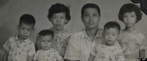
MEXICO CITY — Juan Chiu Trujillo was 5 years old when he left his native Mexico for a visit to his father’s hometown in southern China. He was 35 when he returned.

Migratory patterns and globalization can lead to some intriguing cultural blends that would seem improbable 100 years ago.  This story of shows vividly how ethnicity does NOT always correspond to culture.

See on www.huffingtonpost.com

What Could Disappear?

Coastal and low-lying areas that would be permanently flooded in three levels of higher seas.

This interactive feature is designed to answer a simple, yet profound set of questions.  What areas (in over 20 cities around the U.S.) would be under water if the ocean levels rose 5 feet?  12 feet?  25 feet?  The following set of maps show “coastal and low-lying areas that would be permanently flooded without engineered protection.”

See on www.nytimes.com

Designs to Fit More People in Every City

TED Talks How can we fit more people into cities without overcrowding? Kent Larson shows off folding cars, quick-change apartments and other innovations that could make the city of the future work a lot like a small village of the past.

This talk is relevant not just because it focuses on many urban issues; it also is a fantastic demonstration of how to use spatial thinking to solve problems.

Tagsdensity, urban, spatial, planning, TED.

See on www.ted.com

Top 10 Ways to Go Green this Holiday Season

10 ways to go green this holiday season. Zero Waste holiday tips from Eco-Cycle.

This infographic combined with these recommendations are some simple reminders that mass consumption and waste does not comtribute to global joy or cheer. 

See on ecocycle.org

Keeping up with ‘Geography Education’

Finding Materials: This site is designed for geography students and teachers to finding interesting, current supplemental materials.  To search for place-specific posts, browse this interactive map.  To search for thematic posts (organized by the APHG curriculum) see GeographyEducation.org  Also you can search for a keyword by clicking on the filter tab.

Staying Connected: You can receive post updates in the way that best fits how you use social media.

Update Notifications: Twitter, Facebook, Pinterest.

Email: Click ‘follow’ button at top right of this page.

Sites with Content: WordPress, Scoop.it.

See on www.arcgis.com

More than a club: FC Barcelona and Catalonia’s road to independence

As Catalonia goes to the polls, Sid Lowe looks at one of the region’s great cultural sporting icons and its role in Catalan identity…

Sports and cultural identity of a region are often intertwined. As Catalonia is poised to break from Spain, this video shows how the local teams (especially FC Barcelona) are at the center of political identity and part of the very fabric of the political movement that is pushing for independence.

Tags: sport, Spain, Europe, devolution, autonomy.

See on www.guardian.co.uk

Kids Placemaps

Using addresses you input and your choice of icons, we add your child’s favorite places to a custom neighborhood map that includes real cartographic features, such as street names and north arrow.

What happens when a city planner becomes a parent?  Kids Placemaps!  Combining cartographic expertise and a desire to start geography education at a very early age, the founders of Kids Placemaps have personalized a child’s geography in a tangible, simple fashion.  

See on www.kidsplacemaps.com

Modern Atlantis: Sandy Island shown in marine charts, Google Maps and Earth, doesn’t actually exist

There’s a South Pacific island positioned midway between Australia and New Caledonia featured on various marine charts, world maps, and has appeared in publications since at least the year 2000. It’s listed as Sandy Island on Google Maps and Google Earth, and yet Australian scientists have just discovered it doesn’t exist.

As part of a 25-day voyage, the group went to the area, only to find 1,400m (4,620ft) of the Coral Sea. The team collected 197 different rock samples, more than 6800km of marine geophysical data, and mapped over 14,000 square kilometres of the ocean floor.

See on thenextweb.com

Sahel food crisis

The hunger crisis in the Sahel region of Senegal, Mauritania, Mali, Burkina Faso, Niger and Chad has been deepening since the start of this year.

The Sahel is a classic transition zone–a border that is not a sharp division, but a gradual shift from one region to the next.  This area has environmentally marginal lands, but is as population pressures continue, marginal lands need to sustain more people. 

See on www.guardian.co.uk

Blog at WordPress.com.

Up ↑