Tea plucking machines are threatening the livelihoods of tea pickers in the Indian state of Assam, reports Mark Tully.
Seth Dixon, Ph.D.‘s insight:
This is yet another example of the uneven impacts of globalization.
See on www.bbc.co.uk
Tea plucking machines are threatening the livelihoods of tea pickers in the Indian state of Assam, reports Mark Tully.
This is yet another example of the uneven impacts of globalization.
See on www.bbc.co.uk
Read the Transcript: http://to.pbs.org/b6sR86 The capital of the South Asian country Bangladesh, Dhaka, has a population that is booming. However, it stands …
This is a great introduction to the demographic explosion of the slums within megacities. This is applicable to many themes within geography.
Tags: Bangladesh, water, pollution, poverty, squatter, planning, density, South Asia, development, economic, megacities.
See on www.youtube.com
On three different occasions, the candidate with the most votes didn’t become President of the United States. We call this “The Electoral College Problem.” Here a solution. Simple. Mathematical. Rational.
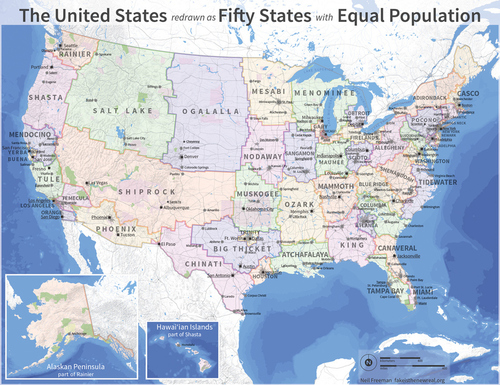
As a disclaimer, I’m not endorsing the removal of all current state borders, but I think that this is a great thought exercise that involves some serious spatial thinking and geography knowledge to create this map (or even to critique and discuss it). This map represents an attempt to restructure the states so that each state would have equal value in the electoral college with roughly equal populations (county borders remained firm). What about the physical and human geography would make some of these “states” better (or worse) than the current configuration of the 50 states? How would this ‘redistricting’ impact your local region?
Tags: political, gerrymandering, mapping, unit 4 political.
See on www.npr.org
The current rise or durability of the economies of the Global South do not signal that economic geography does not matter, but that current investment has simply shifted.
In an era where globalization has rendered distances a minor barrier to diffusion, some have erroneously concluded that geography is no longer relevant to economic development and urban planning. Nothing could be farther from the truth, but that doesn’t mean that the ‘old rules’ of space and place aren’t be re-written. This is a nice article that discusses the continued importance of spatial thinking and geography for urban planning.
Tags: urban, planning, economic, urbanism, globalization, unit 7 cities.
Many of you have seen the YouTube video of the meteor in Russia this week (wondered why so many Russians have cameras on their dashboards?). This show the geologic impact of the largest meteors. Pictured above is Meteor Crater in Arizona.
See on blogs.discovermagazine.com
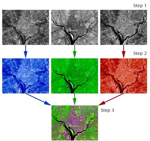
“Satellites acquire images in black and white, so how is it possible to create the beautiful color images that we see on television, in magazines, and on the internet? Computers provide us with the answer.
Images created using different bands (or wavelengths) have different contrast (light and dark areas). Computers make it possible to assign ‘false color’ to these black and white images. The three primary colors of light are red, green, and blue. Computer screens can display an image in three different bands at a time, by using a different primary color for each band. When we combine these three images we get a ‘false color image.’
Find tutorials and links to free compositing programs here.”
Tags: remote sensing, images, geospatial, unit 1 GeoPrinciples.
See on landsat.gsfc.nasa.gov
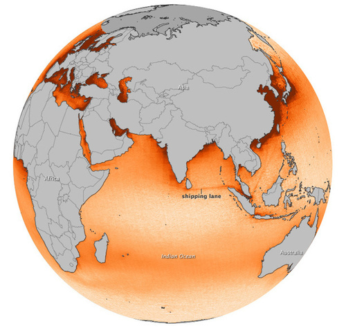
Elevated levels of nitrogen dioxide pop out over certain shipping lanes in observations made by the Aura satellite between 2005-2012. The signal was the strongest over the northeastern Indian Ocean.
See on earthobservatory.nasa.gov
If your knowledge of geography is ‘locked in’, now’s the perfect time to show it off in our Landlocked Countries Geography Quiz! Play now!
See on www.quizfortune.com
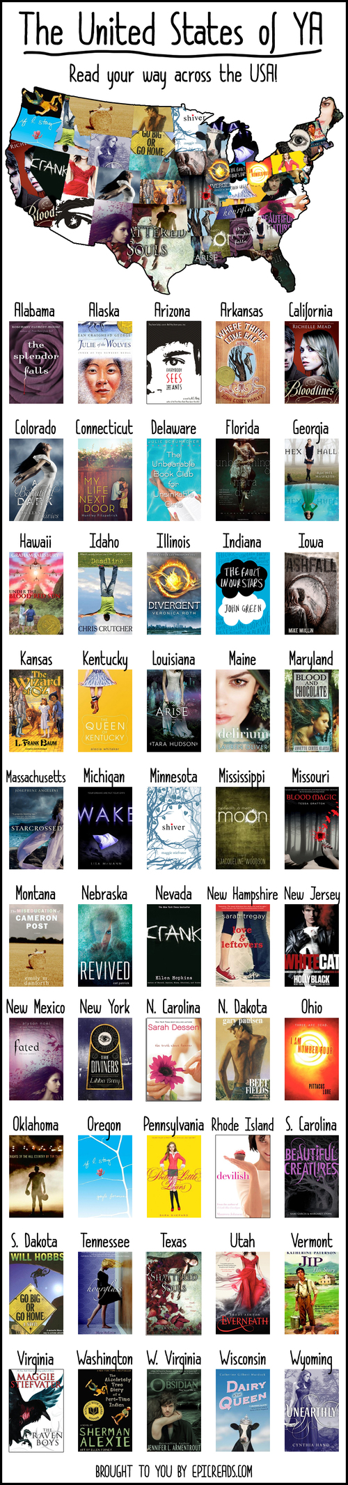
A while back, I posted in the forums asking for people to help me find a YA book for every single state in the US.
While I can’t vouch for all of these books (I read more children’s literature than Young Adult), I absolutely love the idea of this project. This is a great way to make geography a cross curricular activity, especially for an English class or just for fun. The geographic content of some of these books are minimal, but that’s not the worst thing that can happen if more students are reading. What books are at the top of your reading list?
See on www.epicreads.com