Search

GEOGRAPHY EDUCATION

Supporting geography educators everywhere with current digital resources.

Month

March 2015

Road from Europe to U.S.? Russia proposes superhighway

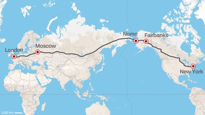
London to New York City by car? It could happen if the head of Russian Railways has his way.

Source: www.cnn.com

As Asya Pereltsvaig, the author of Languages of the World, wrote: “That’s what happens when Russia’s main problems, fools and roads (дураки и дороги), are combined…”  It’s the opposite idea of the summer road trip that is designed to hit all the major tourist sites.


Questions to Ponder: What are the pros and cons of this project?  What would it take to actually happen?  This map is a Mercator Projection–would a different map change your perspective on the feasibility of the project? 


TagsRussia, map projections, transportation, tourism.

Rise and Fall of the Ottoman Empire

“Animated GIF map chronicling the rise and fall of the Ottoman Empire.” 

Tagsempire, devolutionMiddle East, borders, historical, map.

Source: upload.wikimedia.org

How Germanwings Flight 9525 fell to earth

The Airbus A320 airliner en route from Barcelona to Düsseldorf, Germany, suddenly shifted into a rapid dive only moments after reaching its cruising altitude of 38,000 feet.

Source: www.washingtonpost.com

Viva Gentrification!

“In Highland Park, as in other Latino barrios of Los Angeles, gentrification has produced an undeniable but little appreciated side effect: the end of decades of de facto racial segregation. It’s possible to imagine a future in which ‘the hood’ passes into memory.  Racial integration is on the upswing.  For all the fortitude and pride you’ll find in Latino barrios, no one wants to live in a racially segregated community or attend a racially segregated school.”  

Tags: neighborhood, gentrificationurban, place, culture, economic, California, Los Angeles.

Source: www.nytimes.com

iScore5 APHG

Source: itunes.apple.com

iScore5, the app for AP Human Geography is now available in the Apple Store for $4.99. With five levels of questions at increasing difficulty, bonus and double bonus rounds and a study mode with extensive vocabulary, APHG students and teachers alike will find this a great test prep resource and a fun and engaging way to help students earn that 5 (open disclosure–I was a part of the team that developed content for the app, but am NOT receiving any money for promoting it.  I’m sharing it because I’m excited about this new resource).  


Tags: APHG, teacher training, edtech.

Map Projections

A map projection is used to portray all or part of the round Earth on a flat surface. This cannot be done without some distortion.  Every projection has its own set of advantages and disadvantages. There is no “best” projection.  The mapmaker must select the one best suited to the needs, reducing distortion of the most important features.  Mapmakers and mathematicians have devised almost limitless ways to project the image of the globe onto paper. Scientists at the U. S. Geological Survey have designed projections for their specific needs—such as the Space Oblique Mercator, which allows mapping from satellites with little or no distortion.  This document gives the key properties, characteristics, and preferred uses of many historically important projections and of those frequently used by mapmakers today.

Source: egsc.usgs.gov

This article chronicles 18 map projections, how they are mathematically rendered with their own unique set of advantages and disadvantages. 

Questions to Ponder:  Why do map projections matter?  Is one global map projection inherently better than the rest?  What is your favorite?  

Tags: Mapping, visualization, map projections, cartography, perspective.

Archivists unearth rare first edition of the 1815 ‘Map that Changed the World’

A rare early copy of William Smith’s 1815 Geological Map of England and Wales, previously thought lost, has been uncovered by Geological Society archivists.

Source: www.sciencedaily.com

Tide Makes Tombolo an Island

The historic abbey of Mont Saint-Michel became an island on March 21 after a rare “supertide” flooded a causeway.

Source: news.nationalgeographic.com

Coastal physical geography produces some beautiful landforms such as tombolos.  A tombolo is created when sand deposits attach an island to a larger piece of land–think of it as special type of isthmus.  Mont St. Michel (picture above) is the world’s most famous example because of the iconic walled city with crowned with a striking medieval abbey.  As the tides fluctuated, the city and abbey were alternately connected or disconnected from the mainland.  However, a ‘super-tide’ that occurs once every 18.6 years wiped out the artificial causeway stranding motorists on France’s most visited tourist destination (I wouldn’t mind be stranded there right about now).  


Tags: water, physical coastal, geomorphology, landformsFrance,
tourism.

Cartographically Inspired Fashion

I found this on pinterest (where else?) and decided to share the geographically inspired craftiness:

1. Paint your nails white/cream
2. Soak nails in alcohol for five minutes
3. Press nails to map and hold
4. Paint with clear protectant immediately after it dries.

This also works with newspaper, but don’t try it with NatGeo Maps because the paper is of too high a quality to have the ink bleed out; I would recommend using an old USGS Topo map.

Tagsfunart.

Source: geographyeducation.org

Create a free website or blog at WordPress.com.

Up ↑