Search

GEOGRAPHY EDUCATION

Supporting geography educators everywhere with current digital resources.

Month

March 2015

The Runner-Up Religions Of America

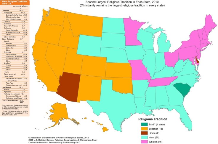
“Glance at the map above, Second Largest Religious Tradition in Each State 2010, and you will see that Buddhism (orange), Judaism (pink) and Islam (blue) are the runner-up religions across the country.

No surprises there. But can you believe that Hindu (dark orange) is the No. 2 tradition in Arizona and Delaware, and that Baha’i (green) ranks second in South Carolina? These numbers, although they look impressive when laid out in the map, represent a very tiny fraction of the population in any of the states listed.”

Source: www.npr.org

This map of the spatial pattern of the second largest religious tradition in each state, tells a different story than the tabular data on the left. 

Questions to Ponder: What are the most interesting stories and patterns visible in the spatial, mapped data?  What is the main second religion that is not as visually dominant on the map?  Why are both data sources valuable in understanding religions in the United States? 

Tags: culturereligion, USA.

A map of all the underwater cables that connect the internet

Cables

Do you know how the internet gets across the ocean? This amazing map shows every cable that makes it possible.

Source: www.vox.com

Because globalization.  

TagsTime-Space Compression, developmenttechnology, economic, globalization, industry, unit 6 industry..

‘Dirty Old London’: Geographies of Human Waste

In the 19th century, London was the capital of the largest empire the world had ever known — and it was infamously filthy. It had choking, sooty fogs; the Thames River was thick with human sewage; and the streets were covered with mud.  But according to Lee Jackson, author of Dirty Old London: The Victorian Fight Against Filth, mud was actually a euphemism. ‘It was essentially composed of horse dung,’ he tells Fresh Air’s Sam Briger. ‘There were tens of thousands of working horses in London [with] inevitable consequences for the streets. And the Victorians never really found an effective way of removing that, unfortunately.'”

Source: www.npr.org

History gets sanitized, and the we forget some of the more unpleasant parts of past geographies.  Victorian London was filthy, but this isn’t just a problem of the past as it remains an urban and developmental issue.  The NY Times just reported on how the sewage system is clogged with wet wipes say aren’t as ‘flushable’ as advertized.  These are the negative externalities of urbanization.  This map of San Francisco shows the spatial and social inequalities of public restrooms and other public amenities for the homeless.  India is the country with the most people without adequate access to sanitary waste disposal and that is a massive impediment to their progress.  Public urination is also health/gender issue and the city of  Hamburg is fighting back with a technological deterrent to public urination (actually quite entertaining).  And if you want the “news of the weird” version of this story on the geography of human waste…well, here you go (you were warned). 

TagsLondonUK, historical, pollution, urban ecologypodcast.

First photographs emerge of new Pacific island off Tonga

The first photographs have emerged of a newly formed volcanic island in the Pacific Ocean after three men climbed to the peak of the land mass off the coast of Tonga. Experts believe a volcano exploded underwater and then expanded until an island formed. The island is expected to erode back into the ocean in a matter of months.

Source: www.telegraph.co.uk

Additionally, here are two islands off the coast of Japan that ‘kissed’ after a volcanic eruption caused them to coalesce into one island

Tags: physicalimages, volcano.

Protecting an Ocean at Risk

“Pristine Seas is an exploration, research, and media project to find, survey, and help protect the last wild places in the ocean. These pristine places are unknown by all but long-distance fishing fleets, which have started to encroach on them. It is essential that we let the world know that these places exist, that they are threatened, and that they deserve to be protected.  Learn more about Pristine Seas here: http://ocean.nationalgeographic.com/ocean/explore/pristine-seas/

Source: www.youtube.com

I was enchanted hearing Enriq Sala discuss his passion for ocean biodiversity and purity.  This passion, combined with scientific exploration and political advocacy is the backbone of a National Geographic’s Pristine Seas project.  Here is one news story about the Seychelles, and how they are trying to manage their fishing industries to promote sustainability and hopefully the Pristine Seas project will lead to greater awareness of the need for ocean conservation. 

Tags: water, conservation, National Geographicphysical, biogeography, environmentpollution, resources.

What’s in a Nickname? In the case of Chiraq, a Whole Lot

“Nicknames are important branding strategies used by civic boosters, and Chicago’s namesakes are frequently employed to market the city and its surrounding region as ‘The Jewel of the Midwest’ and ‘Heart of America.’ At the same time, urban monikers can arise from the wider public and they have sometimes been used to draw attention to negative qualities of Chicago life.”

Source: news.aag.org

Is it Londonderry or just Derry?  Xinjiang or Eastern Turkestan?  The Sea of Japan or the East Sea?  Persian Gulf or Arabian Gulf?  Names and nicknames have political and cultural overtones that can be very important.  As the author of this AAG article on the Chicago’s nickname, Chiraq says, “city nicknames are more than a gimmick; they can define geographies of violence, marginalization, and resistance.”


Tags: Chicago, urban, place, language, toponyms.

The Underground Railroad: Journey to Freedom

“Imagine you are a slave. You belong to a farmer who owns a tobacco plantation on the eastern shore of Maryland. Six long days a week you tend his field. But not for much longer . . .What will you do? Make your choices well as you embark on your journey to freedom.


To play The Underground Railroad: Journey to Freedom, you must download and install the free Sandstone Player Software on your computer. Sandstone is required to support the 3-D style interaction in the game. Click here to find instructions for downloading Sandstone on a Mac or PC.  The game is also available as both an iOS and an android app.”

Tags: USA, historical, National Geographic.

Source: education.nationalgeographic.com

A Sheriff And A Doctor Team Up To Map Childhood Trauma

“The research shows that kids who have tough childhoods — because of poverty, abuse, neglect, or witnessing domestic violence, for instance — are actually more likely to be sick when they grow up. They’re more likely to get diseases like asthma, diabetes and heart disease. And they tend to have shorter lives than people who haven’t experienced those difficult events as kids.”

Source: www.npr.org

The hotspot maps of crime and poverty are correlated (not a big surprise), but this is another example of using spatial data to drive public policy.  After making these initially correlations, they noticed a total lack of services, including medical care in the area that needed it most.  This podcast is the story on how geographic analysis gave birth to a “clinic on wheels.”

Tagsmedical, mapping, GISspatial, neighborhoodpodcast, urban, place, poverty.

When disaster strikes, FEMA turns to Waffle House

FEMA has coined a “Waffle House Index” to indicate the severity of a disaster.

Source: www.marketplace.org

A proxy variable is an easily measurable variable that is used in place of a variable that cannot be measured or is difficult to measure. The proxy variable can be something that is not of any great interest itself, but has a close correlation with the variable of interest.  So if you can’t order waffles after a big storm at Waffle House might not matter in the big scheme of things, but as this podcast demonstrates, it is a good indicator that the region has been serious impacted by a natural disaster–they are the canary in the coal mine that FEMA is using to help plan their relief efforts.  This is in part because Waffle House’s core area is in the South and is has a wide spatial network.


Tags: disastersstatistics, the South, regions, podcast.

Create a free website or blog at WordPress.com.

Up ↑