Search

GEOGRAPHY EDUCATION

Supporting geography educators everywhere with current digital resources.

Month

July 2015

Why are we so reliant on air conditioning? (It’s not just climate change, it’s bad design)

Air conditioners have made architects lazy, and we’ve forgotten how to design houses that might work without it.

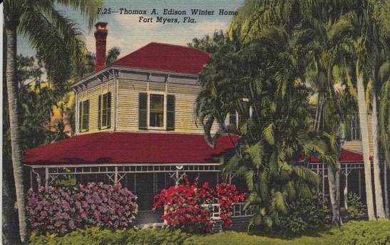
A hundred years ago, a house in Florida looked different than a house in New England. The northern house might be boxy, have relatively small windows, almost always two stories with low ceilings, and a big fireplace in the middle. 

In Florida, the house might have high ceilings, tall double-hung windows, and deep porches. Trees would be planted around the house to block the sun. 

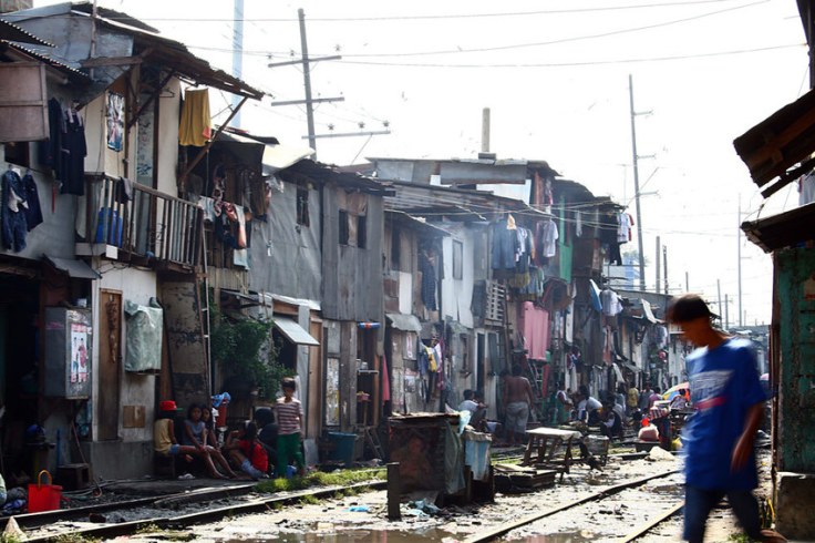
Today, houses pretty much look the same wherever you go in North America, and one thing made this possible: central air conditioning. Now, the United States uses more energy for air conditioning than 1 billion people in Africa use for everything.

Tags: planning, architecture, housingurban, place, environment adaptenergyconsumption.

Source: www.mnn.com

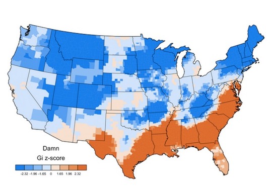
The recent demographic shift to the “Sun Belt” in the U.S.  coincides with the mass availability of air conditioning (among other factors).  Our homes are less regionally distinct and in terms of the human/environmental interactions, our answer is greater modifications as opposed to regional adaptations…this article is a call for more architectural improvements instead of more energy consumption to beat the heat.

The science of slums – Geographical

In an edited extract from his new book, Danny Dorling, professor of human geography at the University of Sheffield, argues that the idea of the population bomb is a fallacy and that the human population is checking its rise without the need for a grand plan

Source: geographical.co.uk

This essay is written by a critic of Thomas Malthus and could serve as a bridge to discuss issues in a population unit and an urban unit.  In a nutshell, Dorling feels that that Malthusian-like fears and assumptions about the proliferation of slums are unfounded; this is a good reading that can spark some conversation in a college seminar. 

Tags: declining populations, population, demographic transition model, urban, megacities, squatter.

China Fences In Its Nomads, and an Ancient Life Withers

The Chinese government is in the final stages of a 15-year-old effort to transform millions of pastoralists who once roamed China’s vast borderlands.

TagsCentral Asia, culturefolk culturesecology, China.

Source: www.nytimes.com

The Chinese government claims that this project is ecological in nature and that pastoralism will degrade the grasslands; however, this is stamping out cultural groups that have been resistant to assimilation. 

The ArcGIS Book

“Explore ten ‘big ideas’ that encapsulate the technological and social trends that have pushed geographic information systems (GIS) onto the Internet in a significant way. See how to apply these ideas to your own world. Open your eyes to what is now possible with Web GIS, and put the technology and deep data resources in your hands via the Quickstarts and Learn ArcGIS lessons that are included in each chapter.”

Source: learn.arcgis.com

I haven’t fully previewed this online textbook yet but I am VERY optimistic about this one from the ESRI library.  You can also download the textbook as a PDF here.  There are several other online textbooks that would interest geography teachers     


Tags: GIS, ESRI, mapping, cartography, geospatial, edtech, geography education, unit 1 GeoPrinciples, textbook.

Island in a Lake on an Island in a Lake on an Island

“Here’s a winning question for your next trivia night: Where is the world’s largest island-in-a-lake-on-an-island-in-a-lake-on-an-island? According to stories published here and here, the distinction currently goes to a nameless isle within Victoria Island in Canada’s Nunavut Territory.

On August 21, 2014, the Operational Land Imager (OLI) on Landsat 8 captured this natural-color view of the “sub-sub-sub-island.” The top image shows a close-up view of the unnamed island, while the bottom image shows a wider view of Victoria Island’s lake-littered landscape (download large image here).”

TagsCanadatrivia, remote sensing, geospatial.

Source: earthobservatory.nasa.gov

How learning to love geography can help make the world a better place

“It’s a good time to reflect on what truly inspires us. What gives us, as individuals, our own sense of independence? And how can we apply that sense of joyful independence to help us engage more actively and participate more readily in the world—to make it a better place, even? Cultivating a better geographical and cultural appreciation for the world, in the next generation as well as in our own, is a pretty good place to start.”

TagseducationK12geography educationperspective, worldwide.

Source: qz.com

American Curses, Mapped

“Americans love to curse. The question is, which bad words are favored where? Who says “*#@&” the most? Who says “$%*#” the least? Is there a “*#$” belt? (As it turns out, yes: From New York City down to the Gulf Coast.)”

Tags: language, culturediffusion, popular culture, mapping, regions.

Source: gawker.com

If you don’t want to hear potty talk, this is not the set of maps on linguistic geography for you…I’m just sayin’, you’ve been forewarned.  An isogloss is a line that separates regions that use different words for the same object/concept.  Thing of isoglosses as linguistic contour lines…are there any swearing isoglosses?  Swearing regions?     

Urbanization in China

China’s citizens are moving from the countryside into cities in record numbers, boosting the economy but making party leaders uneasy

Tags: economic, planning, urban, China, East Asia.

Source: www.youtube.com

A big portion of China’s economic boom the last few decades has been linked to the transformation of what used to be a predominantly agrarian civilization to an economic engine fueled by rapid urbanization.  This 2011 video from the Economist is still highly relevant today.   

99% Invisible

A Tiny Radio Show About Design with Roman Mars

Source: 99percentinvisible.org

I’ve recently wrote about the 99 Percent Invisible podcast and while it is not explicitly (or even always) geographic, it is loaded with excellent materials about design and the details of the world around us that often go unnoticed, but deserve greater scrutiny. 

How did design lead to the the rise and fall of the mall?   (see the oddly fascinating DeadMalls.com for photo galleries in your local area).  How did the expansion of billiards end the horrors of the ivory trade and lead to the age of plastics?  These are some of the questions that the podcast explores.    

Tagspodcast, architecture.

Blog at WordPress.com.

Up ↑