Search

GEOGRAPHY EDUCATION

Supporting geography educators everywhere with current digital resources.

Month

January 2016

xkcd: Terminology

Source: xkcd.com

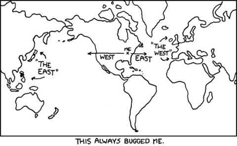
I use this classic xkcd image every semester that I teach world regional geography.  The explanation of this image is helpful if the students fail to understand the context or the point of this comic strip.  The very idea of ‘western’ and ‘eastern’ is very much an idea that comes from ‘the west’ (Greek and Roman civilizations anciently, and a broadly European more recently). The Euro-centric view of the world from a single ‘starting point’ is one reason some geographers don’t like the term ‘Middle East,’ but prefer Southwest Asia and North Africa.  The Middle East implies a European starting point as does the Far East.     


Tagsregions, perspective.

Analyzing Maps to Better Understand Global Current Events and History

In this lesson, we provide strategies to help students accurately interpret maps, and we suggest ways for using current event maps as a tool to better understand both history and what’s going on in the world today.

Source: learning.blogs.nytimes.com

Many of the more fortunate students (access to portable electronic devices, multi-car families with parents who drive them around, etc.) are actually worse off in map reading skills in part because they have never needed to develop a mental map and are not adept at navigating their neighborhoods (in the last few generations most and the range that part).  When these children become drivers, they are unable to navigate without GPS devices, but they still need to learn map reading skills. They are convinced that their apps can do all the work and that an old fashioned paper map is outdated technology, but their spatial thinking skills become atrophied. Spatial skills are crucial for understanding the world as a global citizen, to understand your local environs and for making scientific discoveries.  So teach a kid how to read a map…the sooner the better. 


Tagsmapping, K12, scale, location.

Land Use and Watersheds

George Monbiot: Every year billions are spent in Britain and Europe on policies that wreck homes and lives through flooding

Source: www.theguardian.com

Governments and property owners often act as though a parcel of land is not connected to the broader forces and systems that reshape our Earth.  This article is a reminder that what happens upstream can impact the entire watershed.


Tags: environmentwaterUK, land use, sustainability.

“Green” Iceland gets greener

Country that is 100 percent powered by renewable energy taps into new natural resource.


Tags: Iceland, energy.

Source: www.cbsnews.com

Galapagos Islands and Biodiversity

Radiolab wraps 2015 with a series of special episodes.

Source: www.radiolab.org

The Galapagos Islands (as are most islands) filled with remarkably distinct species from the mainland–one of the key reasons that the island were so instrumental in shaping Charles Darwin’s thinking about evolution.  This environmental Radiolab podcast is mainly about the Galapagos wildlife and it’s conservation and covers many important biogeographic concepts (with time in the episode): 

  • Traveling to the Galapagos (5:25)
  • Who will fight to protect the environment? (10:00)
  • Tortoises and their role in habitats (13:30)
  • Invasive Species and goats (16:30)
  • Removal of Invasive species (19:00)
  • The return of the original habitat (25:40)
  • Local anger against conservation (26:30)
  • ‘Restoring’ extinct tortoise species (30:00)
  • How do we best protect nature? (37:00)
  • Genetically engineering extinct species (41:00)
  • Tourism and ecological change (46:45)
  • Darwin and finches (50:00)
  • Endangered finches and flies (55:00)
  • Hybrid species (1:02:00)


Tags: Ecuador, biogeography, environmentecology, historical.

GeoInquiries for Human Geography

“GeoInquiries are designed to be fast and easy-to-use instructional resources that incorporate advanced web mapping technology. Each 15-minute activity in a collection is intended to be presented by the instructor from a single computer/projector classroom arrangement. No installation, fees, or logins are necessary to use these materials and software.”


Source: geographyeducation.org

ESRI has produced GeoInquires for Earth Science, History and now AP Human Geography.  If you try out an APHG GeoInquiry, please take a moment or two to give the folks at ESRI some feedback (a free book from ESRI for the first reviewers). They are especially looking for reviewers for the GeoInquiries for 1) Distance, transportation, and scale 2) USA Demographics and 3) Agricultural Patterns.  If can get a free ESRI book for your time by assisting them in refining these educational resources.

TagsmappinggeospatialESRI, APHG.

Timeline of the Breakup of Yugoslavia

Map animation depicting the break up of Yugoslavia through the series of political upheavals and conflicts that occurred from the early 1990’s onwards. Different areas of control are colour coded.


Tags: devolutionhistorical, political, states, borders, political.

Source: www.youtube.com

Indonesia on Fire

“In Indonesia’s Central Kalimantan province, the peat areas are burning and emitting a toxic smoke causing untold damage to the environment, wildlife and human health. Most of the fires in Central Kalimantan are blazing in former peatland forests, which have been drained, cleared and burned for oil palm and agriculture, large and small. The dried-out peat ignites easily, burns underground and creeps under the surface. Experts from the Center for International Forestry Research (CIFOR) travel to the heart of the fires to see the situation with their own eyes and measure the extent of the impact.”
More information please visit: http://blog.cifor.org/fire

Source: www.youtube.com

Extreme forest and peat burning in Indonesia has released over three times the annual fossil fuel emissions of the United Kingdom.


An Atlas of the Vikings

“Scandinavia’s history has always been shaped by its geography and orientation to the sea.  The shortage of good farmland in Scandinavia on the whole, however, compelled the Vikings to journey outward. Thus, the sea became an omnipresent part of life. Not only did the barrenness of the soil make the sea an important source of food, but the region’s terrain made water the easier mode of travel for the thinly scattered populations of Scandinavia.”

Source: rigea.maps.arcgis.com

A student of mine produced this excellent Story Map after being inspired by the History Channel’s TV show, Vikings.  History is so often shaped by geographic factors and better understood with maps.     


Tags: mappinghistorical, StoryMapESRI, Denmark, Sweden, Finland, Iceland, Norway.

Blog at WordPress.com.

Up ↑