“A new census that shows that Earth is host to a staggering 3.02 trillion trees — more than scientists expected.The most recent estimate only counted 400 billion trees, reports Rachel Ehrenberg. Because prior studies used satellite technology alone instead of including data from on-the-ground tree density studies, writes Ehrenberg, they missed the mark. They also estimate that since human civilization began, 45.8 percent of all trees been lost.”
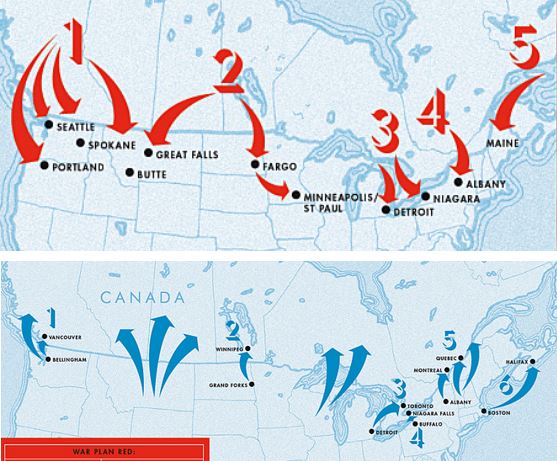
After World War I, Canada drew up classified plans to invade the U.S. Meanwhile, the U.S. had its own secret plot to create the “United States of North America.”
I never knew 1921 to 1930 was such a frosty time in Canadian-U.S. relations that BOTH sides drew up possible invasion plans. Judging by these amazing arrows, these plans were never seriously about to be executed, but it is a good reminder that geopolitical partnerships (and rivalries) are ever-changing. Today, if there are border tensions between these two allies, it might just center around the Arctic as it’s geopolitical importance is rising. Also, I did enjoy the 1920s reference that Americans simply assumed that Canada (once the British Empire was dismantled) would naturally be absorbed by the United States.
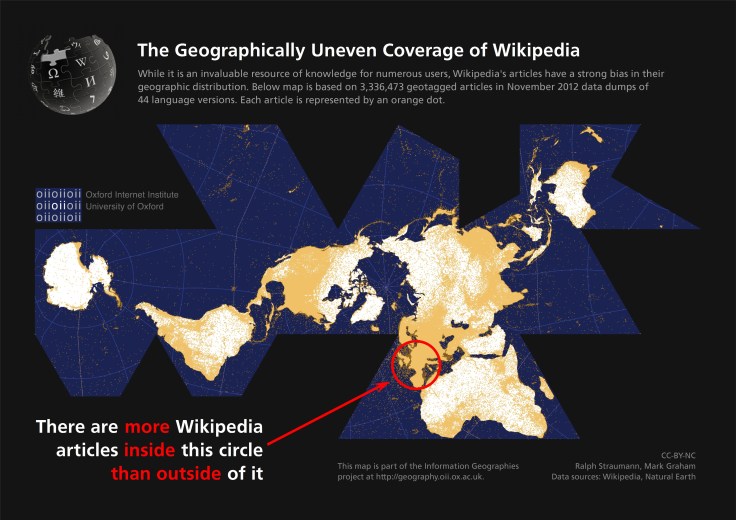
This map points out the highly uneven spatial distribution of (geotagged) Wikipedia articles in 44 language versions of the encyclopaedia. Slightly more than half of the global total of 3,336,473 articles are about places, events and people inside the red circle on the map, occupying only about 2.5% of the world’s land area.
Crowdsourcing is a powerful way to leverage modern digital sharing capabilities, but it inherently going to lead to inequities in the reporting coverage. Why are there so many geo-tagged Wikipedia articles in Europe and not as many elsewhere? What factors account for these discrepancies?
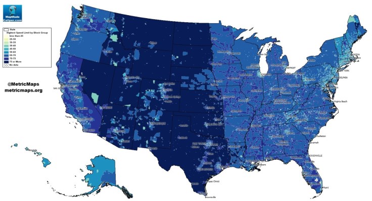
An unconventional look at American roads, mapped by their speed limits.
The above map, from MetricMaps, illustrates that abrupt division using local speed limit data. That map shows the maximum local speed limit for any local roads or highways in each Census block group in the U.S. The nationwide contrasts are striking, but so are the local ones: Zoom in to an individual city like Los Angeles, and the darker arteries effectively outline highways.
This map shows some stark contrast between urban and rural land use patterns–it also shows urban networks that are designed to compression time and space.
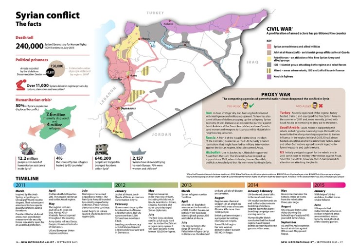
Syria’s civil war has inflicted a humanitarian crisis, expansive exodus of the population and a severe death toll. New Internationalist presents the facts in this zoomable infograph.
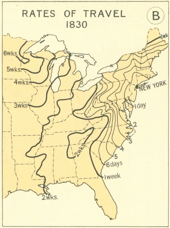
This series of maps shows the great leaps and bounds that were made during the 19th century in transportation technology in the United States. This impacted population settlement, economic interactions and functionally made the great distances seem smaller. This is what many call the time-space compression; the friction of distance is diminished as communication and transportation technologies improve.
Questions to Ponder: When someone says they live “10 minutes away,” what does that say about how we think about distance, transportation infrastructure and time? How is geography still relevant in a world where distance appears to becoming less of a factor?
“For 20 years The Economist has led calls for a rethink on drug prohibition. This film looks at new approaches to drugs policy, from Portugal to Colorado. ‘Drugs: War or Store?’ kicks off our new ‘Global Compass’ series, examining novel approaches to policy problems.”
The distribution of narcotics impacts virtually every country in the world; there are incredibly divergent strategies on how to mitigate these problems that are a result of sophisticated distribution networks. What is the best way to stop the flow of dangerous drugs and the illegal activities that accompany the drug trade? If you were in charge, what strategies would you recommend? Are some solutions a better fit for the political and cultural climates of diverse places?
The Syrian Civil War that stemmed out of the Arab Spring in 2012 morphed into a conflict unlike any of the other Arab Spring protests. In the years before the Arab Spring, Syria experienced an extended drought led to declining agricultural production and social discontent even before the spark of revolutionary change swept the region (see this link from TIME magazine for more information on climate change’s role in the conflict). The rise of ISIS in the power struggle has led to horrifying atrocities that leave ordinary citizens seeking the most basic of human needs: safety, shelter, food and water.
Here are some resources to get you started on teaching about this issue. I’ve realized though, that many students are unsure what to make of the situation because they don’t understand how we got here in the first place. This NPR article is organized to answer these basic questions:
What’s behind this crisis?
Why are they going to Europe?
How risky is the journey?
How are Europe and the international community responding?
Right now in the world there are more refugees than at any time since the end of World War II. There are several regional hot spots of political, ethnic and religious turmoil. This New York Times article is a good exploration into the global refugee crisis, region by region.
This is a good time to teach about the distinctions between the terms migrant, refugee and internally displaced person. All three have left their homes in search of better opportunities, but most migrants are not forced out of their homes; refugees and internally displaced peoples have no choice but to leave because of the incredibly harsh political, environmental or cultural situation back home. Staying is simply not an option for a refugee. Refugees have fled their home country (and crossed an international border into another); internally displaced people have left their homes, but still are in the same country. They are functionally refugees without the same access to international aid and often can be worse off than refugees.
Here are some guiding questions that can help lead a discussion about some of the issues at play without forcing on particular political perspective on your students.
What would you do if you lived in Syria? (This BBC interactive could help them understand the difficulties).
Should other countries take in these refugees? Whose responsibility is it?
What would you do if you were in charge of a European country? How would the local politics shape their international approach?
This video is a good primer to understand some of the factors behind this situation:


