Search

GEOGRAPHY EDUCATION

Supporting geography educators everywhere with current digital resources.

Author

sethdixon

I am a geography professor at Rhode Island College.

World Literacy Map: Literacy Rate Adult Total of People Ages 15 and Above

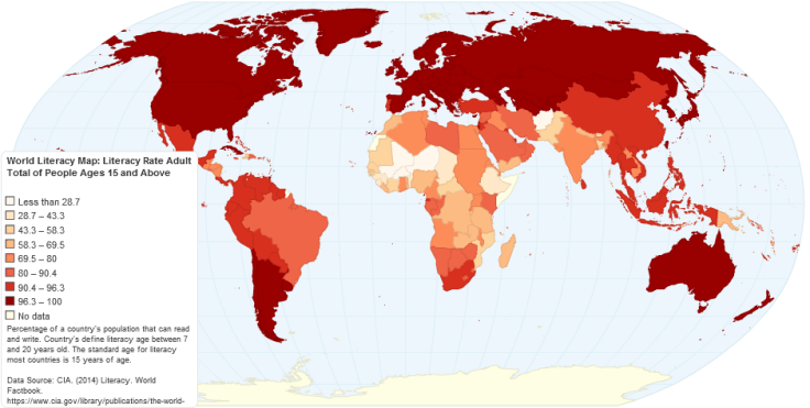
Percentage of a country’s population that can read and write. Country’s define literacy age between 7 and 20 years old. The standard age for literacy most countries is 15 years of age.

TagseducationK12, developmentmap, worldwide.

Source: chartsbin.com

My 10 year-old daughter was looking in our atlas a while back (yes, she is my daughter) and in the encyclopedic entry of each country she started noticing that literacy rates were included.  She started asking about which regions had higher and lower literacy rates. This became a teaching moment about the power of the map–I explained that all this data can be more easily accessed and seen on a map and this interactive map is what we discovered.  We need to help student find the maps and data to answer their questions (and we need to make sure that they are curious enough to ask questions about the way the world works).  

My daughter can’t read a map. And your kid probably can’t either

Ask any teenager for directions and he can pull up Google Maps quicker than you can recite an address. Pretty awesome, right? And I’ll be the first to admit that having a map in my phone that not only tells me where to turn but how long it will take me to get there is pretty amazing. I use it all the time, honestly. But even when I’m zoning out and listening to that soothing voice telling me where to turn, I have a mental picture in my head of her directions. And I never realized that my teenage daughter doesn’t have a map in her head, because she’s never really had to use one. Ever.

Tagseducation, K12geography educationspatial, mapping.

Source: www.washingtonpost.com

Many of the more fortunate students (access to portable electronic devices, multi-car families with parents who drive them around, etc.) are actually worse off in map reading skills in part because they have never needed to develop a mental map and are not adept at navigating their neighborhoods (in the last few generations most and the range that part).  When these children become drivers, they are unable to navigate without GPS devices, but they still need to learn map reading skills. They are convinced that their apps can do all the work and that an old fashioned paper map is outdated technology, but their spatial thinking skills become atrophied. Spatial skills are crucial for understanding the world as a global citizen, to understand your local environs and for making scientific discoveries.  So teach a kid how to read a map…the sooner the better. 

Why are we so reliant on air conditioning? (It’s not just climate change, it’s bad design)

Air conditioners have made architects lazy, and we’ve forgotten how to design houses that might work without it.

A hundred years ago, a house in Florida looked different than a house in New England. The northern house might be boxy, have relatively small windows, almost always two stories with low ceilings, and a big fireplace in the middle. 

In Florida, the house might have high ceilings, tall double-hung windows, and deep porches. Trees would be planted around the house to block the sun. 

Today, houses pretty much look the same wherever you go in North America, and one thing made this possible: central air conditioning. Now, the United States uses more energy for air conditioning than 1 billion people in Africa use for everything.

Tags: planning, architecture, housingurban, place, environment adaptenergyconsumption.

Source: www.mnn.com

The recent demographic shift to the “Sun Belt” in the U.S.  coincides with the mass availability of air conditioning (among other factors).  Our homes are less regionally distinct and in terms of the human/environmental interactions, our answer is greater modifications as opposed to regional adaptations…this article is a call for more architectural improvements instead of more energy consumption to beat the heat.

The science of slums – Geographical

In an edited extract from his new book, Danny Dorling, professor of human geography at the University of Sheffield, argues that the idea of the population bomb is a fallacy and that the human population is checking its rise without the need for a grand plan

Source: geographical.co.uk

This essay is written by a critic of Thomas Malthus and could serve as a bridge to discuss issues in a population unit and an urban unit.  In a nutshell, Dorling feels that that Malthusian-like fears and assumptions about the proliferation of slums are unfounded; this is a good reading that can spark some conversation in a college seminar. 

Tags: declining populations, population, demographic transition model, urban, megacities, squatter.

China Fences In Its Nomads, and an Ancient Life Withers

The Chinese government is in the final stages of a 15-year-old effort to transform millions of pastoralists who once roamed China’s vast borderlands.

TagsCentral Asia, culturefolk culturesecology, China.

Source: www.nytimes.com

The Chinese government claims that this project is ecological in nature and that pastoralism will degrade the grasslands; however, this is stamping out cultural groups that have been resistant to assimilation. 

The ArcGIS Book

“Explore ten ‘big ideas’ that encapsulate the technological and social trends that have pushed geographic information systems (GIS) onto the Internet in a significant way. See how to apply these ideas to your own world. Open your eyes to what is now possible with Web GIS, and put the technology and deep data resources in your hands via the Quickstarts and Learn ArcGIS lessons that are included in each chapter.”

Source: learn.arcgis.com

I haven’t fully previewed this online textbook yet but I am VERY optimistic about this one from the ESRI library.  You can also download the textbook as a PDF here.  There are several other online textbooks that would interest geography teachers     


Tags: GIS, ESRI, mapping, cartography, geospatial, edtech, geography education, unit 1 GeoPrinciples, textbook.

Island in a Lake on an Island in a Lake on an Island

“Here’s a winning question for your next trivia night: Where is the world’s largest island-in-a-lake-on-an-island-in-a-lake-on-an-island? According to stories published here and here, the distinction currently goes to a nameless isle within Victoria Island in Canada’s Nunavut Territory.

On August 21, 2014, the Operational Land Imager (OLI) on Landsat 8 captured this natural-color view of the “sub-sub-sub-island.” The top image shows a close-up view of the unnamed island, while the bottom image shows a wider view of Victoria Island’s lake-littered landscape (download large image here).”

TagsCanadatrivia, remote sensing, geospatial.

Source: earthobservatory.nasa.gov

How learning to love geography can help make the world a better place

“It’s a good time to reflect on what truly inspires us. What gives us, as individuals, our own sense of independence? And how can we apply that sense of joyful independence to help us engage more actively and participate more readily in the world—to make it a better place, even? Cultivating a better geographical and cultural appreciation for the world, in the next generation as well as in our own, is a pretty good place to start.”

TagseducationK12geography educationperspective, worldwide.

Source: qz.com

American Curses, Mapped

“Americans love to curse. The question is, which bad words are favored where? Who says “*#@&” the most? Who says “$%*#” the least? Is there a “*#$” belt? (As it turns out, yes: From New York City down to the Gulf Coast.)”

Tags: language, culturediffusion, popular culture, mapping, regions.

Source: gawker.com

If you don’t want to hear potty talk, this is not the set of maps on linguistic geography for you…I’m just sayin’, you’ve been forewarned.  An isogloss is a line that separates regions that use different words for the same object/concept.  Thing of isoglosses as linguistic contour lines…are there any swearing isoglosses?  Swearing regions?     

Create a free website or blog at WordPress.com.

Up ↑