An animated infographic showing the top three economies throughout history. Does China have the world’s largest economy? Is China’s economy bigger than America’s?
Tags: economic, China, development, India.
Source: www.youtube.com
An animated infographic showing the top three economies throughout history. Does China have the world’s largest economy? Is China’s economy bigger than America’s?
Tags: economic, China, development, India.
Source: www.youtube.com
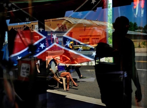
False history marginalizes African Americans and makes us all dumber.
Tags: race, conflict, racism, historical, the South, landscape, monuments.
Source: www.washingtonpost.com
Admittedly, I’ve got a thing for monuments in the cultural landscape. This is a very nice article for a historical geographer on how memory and heritage are enshrined in the landscape; this process politicizes history in ways that shape the national narrative, and that shapes how we think in past. Using historical geography to understand the debates on the news? No way!!

Greece is losing professionals as they flee for more stable employment elsewhere, and the health care sector has been particularly hard hit.
Tags: Greece, Europe, migration, supranationalism, currency, economic, podcast.
Source: www.nytimes.com

The Ring of Fire is a string of volcanoes and sites of seismic activity, or earthquakes, around the edges of the Pacific Ocean.
Source: education.nationalgeographic.com
The Ring of Fire is a series of plate boundaries where earthquakes and volcanic activity are commonplace. Surrounding the edge of the Pacific Ocean, the Ring of Fire consists of a string of 452 volcanoes.
“Papua New Guinea gained independence from Australia in 1975 and has over 800 languages; 87% of the population lives in rural areas.”
Tags: Papua New Guinea, Oceania.
Source: www.youtube.com

Tips from a geographer who’s seen it all.
Tags: mapping, cartography, 201, perspective, map.
Source: www.citylab.com

“Lake Urmia in northwestern Iran was once one of the largest saltwater lakes in the Middle East, but it has diminished dramatically. Diversion of water from local rivers for agricultural use is one likely cause. Since 1996, drought has further contributed to the decline. The lake now covers about 10 percent of the area it covered in the 1970s. In the 2014 image, the entire southern portion of the salty lakebed is exposed. Also see this set of images.”
Tags: Iran, remote sensing, geospatial, unit 1 Geoprinciples, land use, food, food production, environment.
Source: climate.nasa.gov
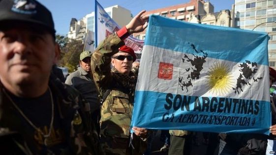
A judge in Argentina orders the seizure of assets of firms drilling for oil around the Falklands, but it is unclear how it can be enforced.
Source: www.bbc.com
Are they the Falklands or Las Malvinas? It’s not just a simple linguistic translation but also a statement of territoriality and geopolitical recognition in this festering situation. For a great teaching resource on the historical ebbs and flows in this longstanding dispute between Argentina and the UK, see the second slideshow in this series of AP Human Geography talks that was given at NCGE two years ago.
Tags: Argentina, borders, political, territoriality, sovereignty.

Have we mapped the whole planet? As Rachel Nuwer discovers, there are mysterious, poorly charted places everywhere, but not for the reasons you might think.
Tags: mapping, cartography.
Source: www.bbc.com


