Search

GEOGRAPHY EDUCATION

Supporting geography educators everywhere with current digital resources.

Author

sethdixon

I am a geography professor at Rhode Island College.

Help the Nepal Aid Effort By Making a Map

Become one of the citizen cartographers around the globe tracing and checking roads, buildings, and open spaces to assist people on the ground.

Source: www.citylab.com

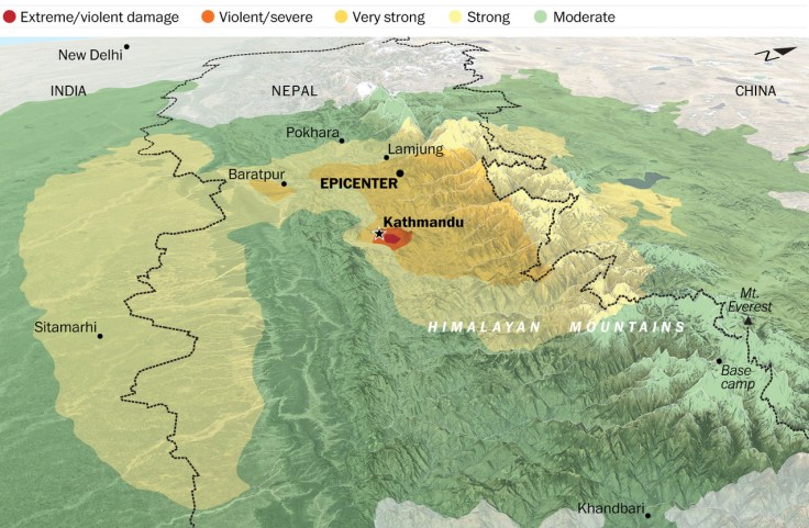
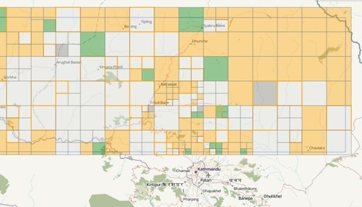
If you want to help Nepal, you can donate time and geospatial abilities by helping provide workers with better maps.  This is probably one of the easier on-ramps to collaborative mapping, and the help is desperately needed.  You can also have students explore the Nepal earthquake in ArcGIS online; this has become a ‘teachable moment’ and  IRIS provides powerpoint slides for teachers to this example in the classroom.


Tags: Nepal, disasters, physical, tectonics, mapping, geospatial.

Sixty Languages at Risk of Extinction in Mexico—Can They Be Kept Alive?

Sixty of Mexico’s native languages are at risk of being silenced forever—but many people are working to keep them alive, experts say.

Source: news.nationalgeographic.com

If is a language dies, an entire culture dies. Every year more and more languages and threatened and it gets worse as more people try to keep up with the demand of globalization. “Mexico isn’t the only country losing its voices: If nothing is done, about half of the 6,000-plus languages spoken today will disappear by the end of this century.”  Endangered Languages are going to be all the more common.  

TagsMexico, language, folk cultures, culture, globalization.

These two maps show the shocking inequality in Baltimore

How vacant houses trace the boundaries of Baltimore’s black neighborhoods.

The map on the left shows one very tiny dot for each person living in Baltimore. White people are blue dots, blacks are green, Asians are red and Hispanics yellow.The map on the right shows the locations of Baltimore City’s 15,928 vacant buildings. Slide between the two maps and you’ll immediately notice that the wedge of white Baltimore, jutting down from the Northwest to the city center, is largely free of vacant buildings. But in the black neighborhoods on either side, empty buildings are endemic.


Tags: neighborhood, gentrificationurban, place, economicracepoverty, spatialhousing.

Source: www.washingtonpost.com

An Archive of the World’s Freshest Satellite Images

A new tool lets you search NASA-quality photos of Earth from 2013 up to this very minute.

Last month, we wrote about Mapbox’s envelope-pushing Landsat-live map. Fed by gorgeous, high-res imagery of the planet captured every 16 days by the USGS’ Landsat 8 satellite, the map offers a first-of-its-kind chance to explore the Earth’s surface as it appears in (almost) real time.

It’s no surprise that other folks are also making moves on that Landsat data. Satellite and software company Astro Digital just released a way to easily browse Landsat imagery dating back to in February 2013 (the launch of Landsat 8) through this very moment (Landsat is constantly rephotographing the planet in patches).


Tags: mapping, perspective, remote sensing, geospatial.

Source: www.citylab.com

When Wearing Shorts Was Taboo

In certain places in American history, showing a little leg has been illegal — for men and women.

Source: www.npr.org

What is cultural acceptable varies over time and space.  This particular issue may seem silly now, but it is a reminder that the norms of the here and now, might have been seen as revolutionary or scandalous in a different time and place.  Cultures and customs are socially mediated and those processes creates cultural norms–norms are continually enforced, resisted and reshaped.     


Tags: culture, folk cultures, unit 3 culture.

It wasn’t just the Armenians: The other 20th century massacres we ignore

“Last week marked the 100th anniversary of the killings of more than a million Armenians during the dying days of the Ottoman Empire. Despite considerable opposition from the Turkish government, the anniversary is bringing renewed attention to an often overlooked historical issue, with President Obama in particular facing criticism for not using the word ‘genocide’ to describe the killings. The 20th century was bloody and violent, and while some horrors are at least relatively well-known – the Holocaust or the genocides in Rwanda and Cambodia, for example – others have become mere footnotes in history.”

Tags genocidepolitical, conflict, war, refugees, empirecolonialism, historical.

Source: www.washingtonpost.com

An earthquake felt across South Asia

“The magnitude-7.8 earthquake that struck Nepal on Saturday morning destroyed parts of Kathmandu, trapped many people under rubble and killed more than 2,500 people. It was the worst to hit the country since a massive 1934 temblor killed more than 8,000.”

Source: www.washingtonpost.com

Even though we know that with the plate tectonic boundaries where these disasters are more likely to occur, it never fully is expected.  These before and after pictures are heart-rending and full the extent of the damage is hard to comprehend (explore in ArcGIS online).

Geographer Jon Kedrowski has a blog about his mountaineering and expeditions. He is up on Everest now, and his blog has a description of the earthquake and the resulting avalanche. The pictures and descriptions are both sobering and fascinating.

*This post was prepared in collaboration with Dr. Deborah Hann of the Texas Alliance for Geographic Education.


Tags: Nepal, disasters, physical, tectonics.

Earth’s tectonic plates skitter about

“Geoscientists have unveiled a computer model that maps the details of that tectonic dance in 1-million-year increments—practically a frame-by-frame recap of geologic time. It shows that the plates speed up, slow down, and move around in unexpectedly short bursts of activity. It also suggests that researchers may have to rethink what drives much of that incessant motion.  The new model shows that although plates usually creep along at an average speed of about 4 centimeters per year, some can reach much faster speeds in short sprints. For example, India, which broke off the east coast of Africa about 120 million years and is now plowing into Asia, reached speeds as high as 20 centimeters per year for a relatively brief 10 million years.”

Tagstectonicsphysicalgeomorphology, video.

Source: news.sciencemag.org

Seaweed Farms in South Korea

The dark squares that make up the checkerboard pattern in this image are fields of a sort—fields of seaweed. Along the south coast of South Korea, seaweed is often grown on ropes, which are held near the surface with buoys. This technique ensures that the seaweed stays close enough to the surface to get enough light during high tide but doesn’t scrape against the bottom during low tide.

The Operational Land Imager (OLI) on Landsat 8 acquired this image of seaweed cultivation in the shallow waters around Sisan Island on January 31, 2014. Today, about 90 percent of all the seaweed that humans consume globally is farmed. That may be good for the environment. In comparison to other types of food production, seaweed farming has a light environmental footprint because it does not require fresh water or fertilizer.

Source: earthobservatory.nasa.gov

Create a free website or blog at WordPress.com.

Up ↑