Search

GEOGRAPHY EDUCATION

Supporting geography educators everywhere with current digital resources.

Author

sethdixon

I am a geography professor at Rhode Island College.

How Watermelons Became a Racist Trope

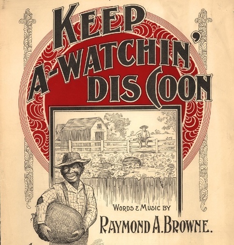
Before its subversion in the Jim Crow era, the fruit symbolized black self-sufficiency.

The stereotype that African Americans are excessively fond of watermelon emerged for a specific historical reason and served a specific political purpose. The trope came into full force when slaves won their emancipation during the Civil War. Free black people grew, ate, and sold watermelons, and in doing so made the fruit a symbol of their freedom. Southern whites, threatened by blacks’ newfound freedom, responded by making the fruit a symbol of black people’s perceived uncleanliness, laziness, childishness, and unwanted public presence. This racist trope then exploded in American popular culture, becoming so pervasive that its historical origin became obscure.”

Tags: culture, racism, historical.

Source: www.theatlantic.com

Recent Developments in the Ukraine Conflict

“Stratfor Military Analysts Paul Floyd and Sim Tack discuss how Russia’s strategy will maintain options as violence in eastern Ukraine continues.”

Tags: Ukraineconflict, geopoliticspolitical.

Source: www.youtube.com

How Wolves Change Rivers

“When wolves were reintroduced to Yellowstone National Park in the United States after being absent nearly 70 years, the most remarkable ‘trophic cascade’ occurred. What is a trophic cascade and how exactly do wolves change rivers?”

Source: www.youtube.com

When a complex system gets one aspect of it changed, there are many other changes that occur, some of which are nearly impossible to envision beforehand.  Here is some Oregon State research on the changes in Yellowstone’s ecosystems and physical environments since the introduction of wolves. 

Tagsecology, biogeography, environment, environment adapt, physical, fluvial.

This map shows where the real child vaccination problems are

India and Nigeria, not California.

Vaccinations and public health are in the news lately, mostly with a focus on the United States. But it’s worth taking a look at this map Benjamin Hennig made of where children go unvaccinated on a global basis to help put things in perspective: You can see here that India (the enormous yellow blob) and Nigeria (the large light-orange blog that dominates western Africa) are the two countries that combine very large populations with low immunization rates. The Philippines, Indonesia, Bangladesh, Congo, and Ethiopia also seem like major problem spots. Clearly in most of these places the problem is a lack of financial and institutional resources rather than explicit anti-vaccine sentiment. Insofar as politics are relevant it’s in terms of setting priorities.

Tagsmedical, development.

Source: www.vox.com

The Most Common Job In Every State

“The jobs picture has changed profoundly since the 1970s. This interactive map and accompanying charts show how those changes played out across the country.”

Tags: economic, labor, USA, transportation, industry.

Source: www.npr.org

Is Your Neighborhood Changing? It Might Be Youthification, Not Gentrification

One urban planning professor has defined this as a process that occurs in discrete stages.

Much has been made of the wave of millennials moving to cities. In intriguing new work, geographer and urban planner Markus Moos of the University of Waterloo gives the phenomenon a name: “youthification.” Moos defines youthfication as the “influx of young adults into higher density” cities and neighborhoods. And in some ways these neighborhoods are “forever young,” where new cohorts of young people continue to move in as families and children cycle out in search of more space.

Tags: neighborhood, gentrificationurban, place, culture, economic.

Source: www.citylab.com

Remember the Alamo

“The battle between the Alamo garrison and Mexican President Santa Anna’s forces reads like a Shakespearian tragedy: greatly outnumbered, all the Texan defenders died. Even the men who surrendered were killed, fueling the outrage and critical mass required to swell the Texan army, become an independent republic, and in time choose to be annexed by the United States.”

Source: maps101blog.com

When we talk about sacred space we often think about religious sites first.  Places like the Alamo or Ground Zero can be seen as critical parts of a national identity and as secular sacred spaces.  Powerful social groups carefully construct memorials at places to strengthen a communal identity.  What makes them tricky is they don’t mean the same thing to everyone—even within a cultural group. 

Tagspodcast, Maps 101, historical, place.

Quiz: Can you name a food just by looking at where it comes from?

I map the food, you tell me what it is.

Source: www.washingtonpost.com

This 12 question quiz is a great way to introduce students to spatial patterns of agricultural products in the United States.  Sometimes just knowing regional stereotypes can be helpful, but being able to make an educated guess about where an agricultural product is comes from requires a basic understanding of economic and climate patterns.  This quiz is a good way to test that knowledge and introduce them to these spatial patterns.    

Tags: triviaspatial, regions, foodeconomicfood production, agriculture.

Saudi Arabia’s Leadership

Source: www.youtube.com

King Abdullah of Saudi Arabia passed away on Jan 23rd and has been replaced by King Salman.  What does that mean for Saudi Arabia?  What will it mean for the region?  The Plaid Avenger has the answers (here are the links for part 2 and part 3).

TagsSaudi Arabiaculturegeopoliticspolitical, Middle East.

Blog at WordPress.com.

Up ↑