Search

GEOGRAPHY EDUCATION

Supporting geography educators everywhere with current digital resources.

Author

sethdixon

I am a geography professor at Rhode Island College.

The Great Green Wall

See on Scoop.itGeography Education

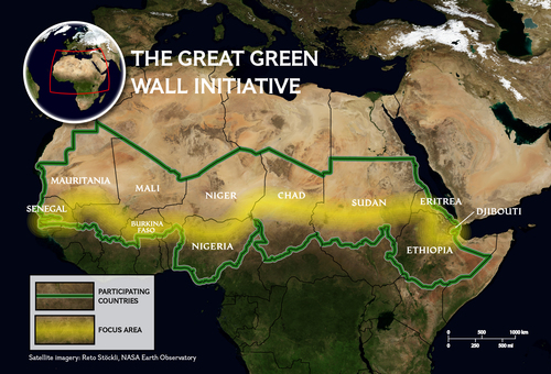
The Great Green Wall initiative uses an integrated approach to restore a diversity of ecosystems to the North African landscape.

Seth Dixon‘s insight:

The Great Green Wall initiative is composed of 11 countries that are cooperating together to combat the physical and human geographic characteristics that make the Sahel one of the more vulnerable ecosystems in the world.  This swath running through Africa is the transition zone where tropical Africa meets the Sahara.  The Sahel is susceptible to drought, overgrazing, land degradation and desertification.  These issues of resource management and land use transcend international borders so this “Green Wall” was created with the intent to protect the environment, landscapes and people of the Sahel from desert encroachment (as an aside, the Green Wall spatially corresponds nicely with the apocryphal Mountains of Kong). 

Tags: Africa, development, environment, waterbiogeography, ecology, environment depend, physical, weather and climate, supranationalism, political ecology.

See on education.nationalgeographic.com

What is halal meat?

See on Scoop.itGeography Education

“There have been calls for clearer labelling of halal products in shops, restaurants and takeaways. But what is halal food? And why are campaigners so concerned?”

Seth Dixon‘s insight:

I know just enough Arabic to read the word Halal (حلال) and know that it means permissible, the opposite of Haram (حَرَام‎) which means forbidden or illegal.  In the context of meat, it means meat that has been prepared in accordance with Islamic traditions and is therefore permissible for an observant Muslim to eat (very similar to Kosher for Jewish people).  Today, Halal is becoming an important issue within the European Union for two main reasons: 1) more Muslims are migrating to Europe and 2) Europeans are searching for less artificial food products.  Some Europeans, however, feel that the Halal labeling and marketing is a change to the cultural landscape that they are not comfortable with, and don’t want to see it become more mainstream.  Other meat companies try to present their products as Halal, but don’t adhere to all of the customs according to some more strict Muslims.  Halal, then is a lightning rod, in either direction right now in Europe.  If you want to see the inner workings of a Halal slaughterhouse in New York, this video will show you what it is like.   

See on www.bbc.com

Comparing Urban Footprints Around the World

See on Scoop.itGeography Education

In the above poster the cities are arranged (roughly, in order to maximize space) by population. Clearly, size and population are not directly correlated. Some cities take up a lot more space for a smaller population. The relationship between the two, of course, is known as density (population density, urban density).

Seth Dixon‘s insight:

I shared this a while back, but the creator has since revised the data and updated the layout for the main infographic. The entire set of infographics are tremendous visual tools to compare urbanization patterns around the world. 

See on matthartzell.blogspot.com

Growth Rings

See on Scoop.itGeography Education

“Maps Of U.S. Population Change, 2000-2010.  Blue is population increase, red represents population decline.”

Seth Dixon‘s insight:

This series of maps shows important patterns impacting American cities today.  Pictured above is Detroit, emblematic of urban decline, but some of the patterns that we see in Detroit are happening elsewhere in the United States (but not was pronounced).  Three patterns are especially noteworthy: 1) Decline of the urban core, 2) Growth in the suburban ring but most especially 3) a revitalization of the downtown (specks of blue in the sea red). 


Questions to Ponder: So what processes are creating these patterns?  Have does this information mesh with, or change our understanding of the urban models?     

Tags: urban, planning, unit 7 cities, urban models, economic.

See on www.datapointed.net

‘I will sell them,’ Boko Haram leader says of kidnapped Nigerian girls

See on Scoop.itGeography Education

Fears for the fate of more than 200 Nigerian girls turned even more nightmarish when the leader of the Islamist group that kidnapped them said he’ll sell them.

Seth Dixon‘s insight:

I have hesitated to post about this topic for several reasons (unsure of the regional context, painful topic, religious overtones, etc.) but feel that it is important enough that it simply can’t be ignored.  The abductions have triggered massive protests as we see the convergence of modern social mobilization and intelligence versus old-fashioned brute force.


Tags: Nigeria, slavery.

See on www.cnn.com

Uneven Population Distribution

See on Scoop.itGeography Education

“60% of Iceland’s population lives in the red area.”

Seth Dixon‘s insight:

Similar to Iceland, Australia’s population is also highly clustered.    


Questions to Ponder: Why is Iceland’s population so highly clustered?  What is it about the red (and white) areas on the map that explain this pattern?  What other layers of information do we need to properly contextualize this information?  


Tags: Iceland, population, density.

See on www.reddit.com

Borderlands: The New Strategic Landscape

See on Scoop.itGeography Education

Seth Dixon‘s insight:

Since the Russian annexation of Crimea, the interest in geopolitics has climbed.  Many feel as though the post-Cold War World political paradigm has changed and it has.  John Kerry has even accused Russia of using 19th century tactics to solve 21st century problem.  This comment highlights how many Americans and American government officials took for granted that the ‘New World Order’ after the fall of the Soviet Union was a permanent condition.  This article from Foreign Policy argues that it is the Americans how are caught in a geopolitical time warp, imagining that the American global hegemony of the 1990s represented the ‘end of history,’ and that geopolitical power will still be a major force in the foreseeable future.  With this in mind old concepts in geopolitics such as borderlands and buffer zones are being revived and analyzed anew.

Tags: geopoliticspolitical, conflict.

See on www.stratfor.com

Population pyramids: Powerful predictors of the future

“Population statistics are like crystal balls — when examined closely, they can help predict a country’s future (and give important clues about the past). Kim Preshoff explains how using a visual tool called a population pyramid helps policymakers and social scientists make sense of the statistics, using three different countries’ pyramids as examples.”

Seth Dixon‘s insight:

This is an incredibly powerful and remarkably well-done TED-ED lesson on the importance and value of population pyramids.  This lesson goes nicely with this article fro the World Bank entitled “The End of the Population Pyramid” which highlights the demographic changes that will be reshaping global demographics in the next 50-100 years.  

Tag: population, demographic transition model, TED.

22 International Borders

See on Scoop.itGeography Education

“Brazil (top) and Bolivia (bottom).”

Seth Dixon‘s insight:

This photographic exploration of various borders shows that some are are just administrative lines that show peaceful collaboration; others are fraught with geopolitical tension or demonstrate radically distinct land use management patterns. 


Tagsland use, borders, political.

See on www.viralnova.com

Create a free website or blog at WordPress.com.

Up ↑