Search

GEOGRAPHY EDUCATION

Supporting geography educators everywhere with current digital resources.

Author

sethdixon

I am a geography professor at Rhode Island College.

Family Geography Night


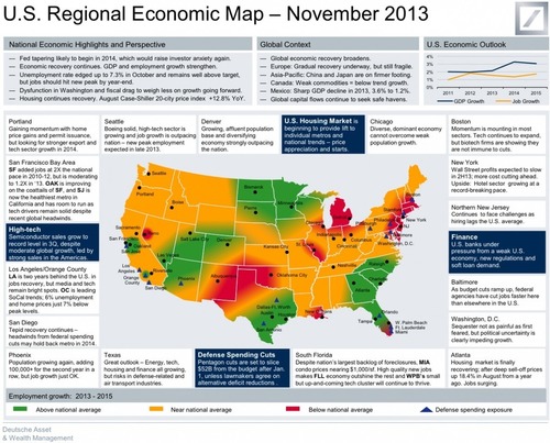
“Are you looking for a way to promote geography in your school in a way that involves students, parents, other teachers and administrators? A Family Geography can absolutely help.  Here are some guidelines to run a Family Geography night at a school or an Alliance function.”

Seth Dixon‘s insight:

I’ve had the privilege of working with NEGEN (New England Geography Education Network). The great people in the Massachusetts Geographic Alliance have collaborated to create a template to run Family Geography Nights at schools. These Family Nights are incredibly successful in showing the relevance of geography education to administrators, other teachers, parents and the general public.

See on www.youtube.co

Fair Housing

Where you live is important. It can dictate quality of schools and hospitals, as well as things like cancer rates, unemployment, or whether the city repairs roads in your neighborhood. On this week’s show, stories about destiny by address.

Seth Dixon‘s insight:

This hour-long podcast addresses some has key issues in urban geography by exploring the history of redlining, the Fair Housing Act and other fair housing initiatives.  The urban cultural mosaic of the United States and the neighborhoods of our cities have been greatly shaped by these issues.  Currently gentrification is reshaping many U.S. cities and fits into the wider scope of the issues raised in the podcast. 

Tags: housingracism, urban, economic, povertyplace, socioeconomic, neighborhood, ethnicity, race, podcast.

See on www.thisamericanlife.org

This Is What Detroit Could Look Like In 2033

If you’ve never been to Detroit and only know what you see in the news, a story about the city’s future could seem confusing. Detroit is bankrupt.

Seth Dixon‘s insight:

Yes, the news about Detroit has been grim, as de-industrialization has negatively impacted this region more than any other in the United States.  Still, many consider Detroit’s economic problems akin to flesh wounds and organ failure.  Extending the analogy, the see Detroit as having ‘good bones,’ something to build on for a new future.  This article represents some visions of that new future.  

Tags: urban, economic, industry, Detroit.

See on www.huffingtonpost.com

Mapping How Americans Talk

Enhanced video based on previous “soda vs. pop vs. Coke” maps

Seth Dixon‘s insight:

I’m from California, and yes, this is a freeway.  This fun 4 minute video highlights some previously shared language maps.  

See on www.theatlantic.com

The State of USA Economy

From Deutsche Asset & Wealth Management.

See on www.businessinsider.com

Using GeoGuessr in the Classroom

GeoGuessr1

In May 2013, GeoGuessr came online and quickly became a favorite quiz game of geo-enthusiasts.  Using 5 random locations in Google Street View.  The game player can search the area in Street View and then make a guess as to where it is on the map.  The closer to the location the more points you receive and the game makes it easy to share your scores and challenge friends on social media sites.  The picture above is in western Australia as the vegetation, soil and open terrain indicates–that is exactly the type of geographic context that the GeoGuessr quiz probes.
So how can a geography teacher leverage this new platform to enhance the classroom experience?  Teachers can allow the students to explore the various locations to analyze the cultural landscape.  It is randomized, but teachers can now create their own GeoGuessr quizzes using GeoSettr.  Anyone can arrange 5 locations into a customized quiz with a unique URL.
GeoSettr Pawtuxet
Google Street View is not global is it’s coverage, limiting the regional usage of GeoGuessr and GeoSettr.  The map below represents (as of 2013) the coverage of Google StreetView.
Google_Street_View_coverage
Below are GeoGuessr games that I have created and potentially some that other educators have created.  Have you created one worth sharing?  Please let me know and paste the URL in the comments section below.
CUSTOMIZED GEOGUESSR QUIZZES
Quiz #1 on urbanization and environmental geography: here are some clues (and more information to contextualize the geographic information that is so much more than just locational coordinates).
  1. Deindustrialization has led to rapid population decline and dramatic property devaluations in this city. Recently this city became the largest U.S. city to ever declare bankruptcy.
  2. This is near my favorite lake to go canoeing…for you movie buffs it was the location for the film “On Golden Pond.”
  3. This entire country is incredibly vulnerable to tsunamis, hurricanes and climate change. This country is composed of 26 atolls with hundreds of micro-islands, this highest elevation in this country 8 feet above sea level.
  4. My favorite National Park is especially noteworthy for geothermal structures. This is the location of the most famous icon in this western National Park.
  5. One of my favorite cities in the world is also one of the largest. It sits in a high altitude basin that traps pollution and requires the county to “import” water resources and “export” waste.
Quiz #2 (Under Construction, and more will be coming):
Thank to Kelly Rexine for bringing this to my attention and his great review of Geosettr.

All-American singer wows Arabs Got Talent with Umm Kulthum cover

Boston-born Jennifer Grout has amazed Middle Eastern viewers, reaching the Arabs Got Talent final despite speaking little Arabic

Born and raised in Boston, Grout’s Arabic accent has inspired debates about whether she is merely pretending to be a westerner. Her fellow contestants are from different parts of the Middle East, and include Mayam Mahmoud, 18, billed as Egypt’s first hijab-wearing rapper.

Seth Dixon‘s insight:

TV shows have regionalized networks, but sometimes the audience wants something beyond their local borders and that pushes the limits of what many think that audience might want or even redefine the audience itself.  Hijab-wearing rappers and blond-haired, blue-eyed girls from Boston singing in Arabic certainly blur the distinction between what we think is Middle Eastern and what think of as American.  Globalization is increasing erasing those cultural lines.

See on www.theguardian.com

DON’T PANIC — The Facts About Population

Don’t Panic – is a one-hour long documentary broadcasted on BBC on the 7th of November 2013.

The visualizations are based on original graphics and stories by Gapminder and the underlaying data-sources are listed here.
Hans’s — “All time favorite graph”, is an animating bubble chart linking health and wealth which you can interact with online here and download offline here.

Seth Dixon‘s insight:

Population growth in an important topic that is connected to economic development.  If you’ve seen Hans Roslings TED talks, this is an hour-long version of many of the same concepts and data visualizations.  His Gapminder data visualization tool, it is a must see for geography teachers to show the connections between population statistics and developmental patterns–let students see the data. 

This is an article that looks at a different factor, arguing that overpopulation isn’t the real issue.   

Tags: gapminder, population, demographic transition modeldevelopment.

See on www.gapminder.org

GNN Podcast: Plymouth and the Pilgrims

Thanksgiving has some fascinating spatial components to it.  My wife and I prepared an article for the Geography News Network that was converted to a podcast; this podcasts shows the historical and geographic context of the first Thanksgiving and in the memorialization of Thanksgiving as a national holiday (if you don’t subscribe to Maps 101, it is also freely available as a podcast on Stitcher Radio or iTunes).

Seth Dixon‘s insight:

One of my favorite combinations of maps for Thanksgiving involves the geography of food production and food consumption.  When we start looking at the regional dishes on Thanksgiving plates we can see some great patterns.  This ESRI storymap asks the simple question, where did your Thanksgiving Dinner come From?

This StoryMap is a great resource to combine with this New York Times article that shows the regional preferences for the most popular Thanksgiving recipes.  Where are sweet potatoes grown?  Where do people make sweet potato pie for Thanksgiving? 

Plymouth County, MA is heart of only 3 cranberry producing regions and is was also home to the first Thanksgiving.  How has this New England local ecology and traditional food patterns influenced national traditions? 

For these and more Thanksgiving resources on scoop.it, click here.

See on maps101blog.com

Create a free website or blog at WordPress.com.

Up ↑