Search

GEOGRAPHY EDUCATION

Supporting geography educators everywhere with current digital resources.

Author

sethdixon

I am a geography professor at Rhode Island College.

Puzzle: Put the Congressional Districts Back Together

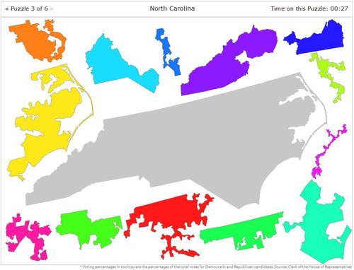
Gerrymandering is the practice of redrawing congressional districts after a decadal census to favor one political party over the other.

Seth Dixon‘s insight:

This interactive mapping activity is an excellent tool to introduce the idea of redistricting in general and gerrymandering to be more specific.  The creation of a new congressional district, or the loss of an old one, affects every district around it, necessitating new maps. Even states not adding or losing congressional representatives need new district maps that reflect the population shifts within their borders, so that residents are equally repre­sented no matter where they live. This ritual carving and paring of the United States into 435 sovereign units, known as redistricting, was intended by the Framers solely to keep democracy’s electoral scales balanced. Instead, redistricting today has become a part of the political game—a way for elected leaders to entrench themselves in 435 impregnable garrisons from which they can maintain political power while avoiding demographic realities. 

And how is gerrymandering a part of the current government shutdown?  Read Thomas Friedman’s opinion on the subject or an opinion from the Economist.

Tags: gerrymandering, political, mapping, census, unit 4 political.

See on www.slate.com

An Insider’s View Of 19th-Century Paris

“Charles Marville photographed Paris’ transition from medieval hodgepodge to modern metropolis.  Marville made more than 425 photographs of the narrow streets and crumbling buildings of premodern Paris, including this view from the top of Rue Champlain in 1877-1878.”

Seth Dixon‘s insight:

This NPR podcast adds some great insight into Charles Marville’s 19th century photography currently on display at the National Gallery of Art in Washington D.C.  The urban transformations designed by Haussmann made Paris the global capital of modernity and the many cities around the world copied the principles of Haussmannization.  A photographic glimpse into Paris before and during these changes that brought about social upheaval is a marvelous tool for an historical geographic analysis of urbanization.     

Tags: urban, historical, Paris, placeFrancepodcastimages.

See on www.wbur.org

3209-002

Marville’s images show the evidence in a picture taken on the right bank of the Seine: There’s the river, Notre Dame Cathedral in the far background and a new wing of the Louvre going up along the riverside.  Back then, before Napoleon and Haussmann, the river was the highway — everything went up and down the Seine.

In analysis of this image, museum curator Sarah Kennel says, “You can see the banks lined with chunks of quarry stone that are going to be used to build Paris, also enigmatic, covered piles of things,” Kennel says. “And you also get a real sense of how much the Seine was the center of industry.  Then they built all the grand boulevards, and it became a place where now you can take nice, lovely boat rides and look at all the monuments.”

Pumpkin Geography

“After spending a month becoming familiar with the location of the seven continents and the major bodies of water, each student is given a pumpkin to turn into a globe. Students paint the entire surface of the pumpkin blue to represent water. Next, they use pushpins to position and trace the outline of each continent onto their pumpkins. They use actual globes as models and are careful to place the continents in the correct hemisphere. Then, they paint and label each continent a different color. They label the major bodies of water and use white paint to represent the North and South Poles.”

Seth Dixon‘s insight:

Happy October everyone!  This is a fun craft to strengthen kids’ mental maps with a seasonal twist.  If you really love pumpkin globes, you should also see this one below.   

See on www.nea.org

Pumpkin

NEARC GIS Educator’s Day

Notes from Seth Dixon’s keynote address at NEARC’s GIS Educator’s Day delivered in Nashua, NH on Sept 29, 2013.

Seth Dixon‘s insight:

I was delighted to invited to discuss the importance of GIS and geospatial technologies in education at NEARC‘s GIS Educator’s Day.  Earlier this year I gave a presentation at Brown University for the Choices Program on a very related topic (so forgive some of the topical overlap).  This slideshare document has hyperlinked slides so you can access the digital resources mentioned in the talk if you wish.  

See on www.slideshare.net

Can We Save Venice?

Seth Dixon‘s insight:

Venice is sinking–no news there.  Some of the sinking is natural based on the geomorphological processes on being in a lagoon and some is based on how people have modified the physical landscape.  The GREEN on the map represents restoration efforts to stabilize the city while the RED indicates that human-caused activities have produced sinking.  Additionally in this new study, researchers have used remote sensing data to differentiate between the anthropogenic sinking (human-caused sinking) and the natural sinking in Venice.  This city is a perfect example of the three major types of human and environmental interactions [we 1) depend on the environment, 2) adapt to the environment and 3) modify the environment] and shows the issues associated with these interactions.  Click here for a hi-res image of Venice and to see why I love the city. 

Tags: physical, remote sensing, geospatial, physical, environment, geomorphology, erosion, environment modify.


See on news.sciencemag.org

Fertility Rates in Gapminder

“CATHOLIC Argentina, Mexico & Phillippines have more babies born per woman than MUSLIM Indonesia, Iran & Turkey.”

Seth Dixon‘s insight:

Gapminder is a tremendous resource that I’ve shared in the past and total fertility rates is an ideal metric to see in this data visualization tool.  As Hans Rosling said in one of his TED talks using Gapminder, religion and total fertility rates are not as connected as previously thought.  In this particular mode, you can see how three predominantly Catholic countries (Philippines, Argentina and Mexico) compare in Total Fertility Rates to three predominantly Muslim countries (Indonesia, Turkey and Iran).  

Questions to Ponder: Historically many have assumed that Catholic and Muslim populations would have higher birth rates; why is this changing?  How important a factor is religion in changing fertility rates?  What are other factors impact a society’s fertility rate?

Tags: population, demographics visualization, religion.

See on www.gapminder.org

The Great Nature Project

Join me and National Geographic’s Great Nature Project in exploring the great nature all around us!

Seth Dixon‘s insight:

Join National Geographic in celebrating the great nature all around us! Go outside and snap a photo of plants and animals you find. Upload photos with #GreatNature. Add #animal to animal photos. View photos from around the world at greatnatureproject.org.

Tags: biogeography, National Geographic. images.

See on www.greatnatureproject.org

The Geography of Soccer in the US

” 549 players from 62 different countries play in MLS in the United States”

Seth Dixon‘s insight:

In the United States, soccer is not as prevalant as it is in so many other countries around the world (but it is growing in importance in the United States as well).  This cultural discrepancy accounts for both of the spatial distribution of where athletes playing in Major League Soccer in the United States come from–answer: all over.  Also, American fans of the English Premier League have distinct preferences based on different cultural meanings behind team affiliations.


Tag: sportspatial.

See on www.mlssoccer.com

Bootlegging in Tribal Pakistan

In Pakistan’s tribal areas, alcohol bootleggers, lured by enormous profits, have created clandestine delivery services to evade recent crackdowns by the Taliban and the police.


Seth Dixon‘s insight:

This 2010 New York Times video shows in a poignant way how the past and the present, the global and the local comibine to create underground cultural practices among the wealthy in Pakistan. 

Tags: Pakistan, popular culture, SouthAsiaglobalization, culture, Islam.

See on www.nytimes.com

Create a free website or blog at WordPress.com.

Up ↑