Search

GEOGRAPHY EDUCATION

Supporting geography educators everywhere with current digital resources.

Author

sethdixon

I am a geography professor at Rhode Island College.

Thinking Green in Pittsburgh

Pittsburgh, called “hell with the lid taken off” in the 19th century because of its industrial filth, is now an academic leader in the green movement.

Seth Dixon‘s insight:

This is a great article on regional sustainability initiatives and education in the Pittsburgh area.  Given Pittsburgh’s history, that makes these clean industrial projects all the more impressive.    

See on www.pittsburghmagazine.com

Ethnic/Population Density Map

NORTHEAST

“Drawing on data from the 2010 U.S. Census, the map shows one dot per person, color-coded by race. That’s 308,745,538 dots in all.”

Seth Dixon‘s insight:

This is an incredibly gorgeous interactive map of population density in the United States.  It is very reminiscent of this North American Map with two major differences.  On the down side, Mexican and Canadian data are not displayed but on the bright side, the added color component is used to show ethnic categories as defined by the 2010 U.S. census.  Please explore this map at a variety of scales and in distinct locales.

Questions to Ponder: Is this a map of ethnic diversity patterns or is it a map of racial segregation?  How come?  Is there additional information that you would need to decide?  This review of the map on Wired described this map as a map depicting segregation: why would they say that? 

Tags: cartography, mapping, visualization, population, density, ethnicity. race.

nycnolabel

Geography/Common Core Webinar

“If you’re concerned about Common Core and how geography fits in then don’t miss this informative event. We’ll dive into resources that were designed to expand the definition of text, show the alignment between the ELA common core standards and Geography for Life along with suggesting teaching ideas. This presentation will focus on the ELA and Geography Interconnections document that was created to support educators. The session will also highlight the National Geographic Common Core website and the resources available. Join us for a look into Common Core Standards and Geography Education!”

Seth Dixon‘s insight:

NCGE and National Geographic Education have partnered to bring you the first free partnership webinar of the 2013-2014 NCGE Webinar Series!  This webinar is tomorrow evening (Wednesday August 28th, 9:00pm EDT) so register ASAP!  I’ve posted some resources in the past about how geography and the Common Core can be aligned; this webinar will pull together years of work to ensure that geography does not get squeezed out of the curriculum.  

Tags: common coreEnglishNCGE, National Geographic, geography education, teacher training.

See on attendee.gotowebinar.com

High School Students Interviewed

Jay Leno interviews high school students knowledge of global issues and geographic understanding…as I’m sure you can guess, it isn’t pretty.

Seth Dixon‘s insight:

If you want your students to be able to laugh at other students that aren’t actually in your classroom, Jay Leno can always find a pool of people willing to embarrass themselves in front of the camera (mocking and being mocked was a major part of my junior and high school experiences).  This and about a dozen other videos are compiled together in this start-of-the-year video list

See on www.youtube.com

GPS Astray: Lost in Death Valley

Part 1: Three women’s Death Valley day trip soured after their GPS led them to the edge of survival.

Seth Dixon‘s insight:

This is a extreme example, but this video serves as a cautionary tale.  The harsh and unforgiving physical geography of Death Valley does not tolerate a lack of preparation.  Here is part 2 of the video.  Garmin the GPS manufacturer’s statement on these videos is quite telling “GPS’s shouldn’t be followed blindly…it is incumbent on users to obtain and update their GPS devices with the most recent map updates.” 

Technology is designed to guide and assist our decision-making process–that does NOT mean we should turn over thinking functions to the device.  Spatial thinking is just like a muscle that will atrophy if it is never used.  So consult a map and think for yourself; newer technologies aren’t always better or more reliable.   

Tagsmapping, GPS, geospatial, location, California,

See on abcnews.go.com

GPS

Linguistic Diversity at Home

“Counties where at least 10 percent of people speak a language other than English at home.”

Seth Dixon‘s insight:

While this is ostensibly a map that would be great for a cultural geography unit, I’m also thinking about the spatial patterns that created this map.  What current or historical migrations account for some of the patterns visible here?  What would a map like this look like it it were produced 50 years ago?  Why are Vermont and West Virginia the only states without a county with over 10% of the population that speak another language at home?  

Tags: language, North America, mapping, regions, census, migration, populationhistoricalfolk cultures, USA.

See on www.washingtonpost.com

When Google Earth Goes Awry

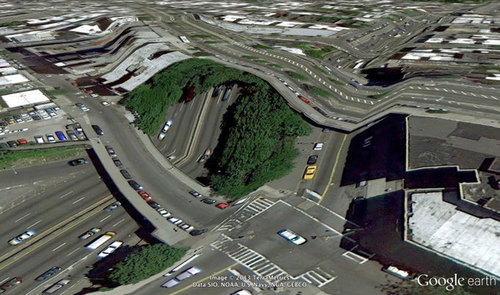
These jarring moments expose how Google Earth works, focusing our attention on the software. They reveal a new model of representation: not through indexical photographs but through automated data collection from a myriad of different sources constantly updated and endlessly combined to create a seamless illusion; Google Earth is a database disguised as a photographic representation. These uncanny images focus our attention on that process itself, and the network of algorithms, computers, storage systems, automated cameras, maps, pilots, engineers, photographers, surveyors and map-makers that generate them.”

Seth Dixon‘s insight:

The quote above from Clement Valla shows some of the problems with trusting too completely in a form of technology if you are not sure how it works or what its limitations are.  What does he mean when he says “Google Earth is a database disguised as a photographic representation?”  What does this have to do with the term metadata?   

Tags: cartography, visualization, mapping, art, google.

See on twistedsifter.com

Religious Geographies

Seth Dixon‘s insight:

PleweMapping

I recently got my hands on a fabulous atlas entitled Mapping Mormonism which shows the historical geographies of this particular Christian denomination.  I’ll briefly share just this one cartogram above that is from the atlas; it displays territory not by the size of the landmass but by the LDS population living within the given territory.  While we would expect to see Utah to be very large on this cartogram, are there other pockets of large LDS populations that are surprising to you?  What explains the small spatial distribution patterns of limited diffusion that you see?  The LDS church is well-known for its missionary program and proselytizing efforts—does that play a role in this map?

On a related side note I found a curious political/religious map of the United States (a map that is partially explained by understanding some of the patterns on the map above).  The most typical religious maps show where particular religions are pre-dominant.  This map shows territories marked not by the faith of the residents but by the religion of the local congressmen.  This make me wonder:  Is this map religious or political? Is there valuable information to glean from this maps or is it simply a fun curiosity?  How does the religious geography of the United States impact political geography (or vice versa)?   

BuzzfeedReligion

Tags: religion, culture, diffusion, mapping, historical, cartography.

See on mappingmormonism.byu.edu

Drainage Patterns

“The incredible fractal pattern rivers (now dried out) were made as they spread into the salt flats of the arid Baja California Desert in Mexico.”

Seth Dixon‘s insight:

Who says teaching about geomorphology has to be boring?  This image of a dendritic drainage pattern beautifully shows the most common spatial pattern. 

See on photography.nationalgeographic.com

Create a free website or blog at WordPress.com.

Up ↑