From Brooklyn Bridge to Sydney Harbour Bridge, our Landmark Bridges Quiz challenges your knowledge of some of the most famous bridges from around the world!
See on www.quizfortune.com
From Brooklyn Bridge to Sydney Harbour Bridge, our Landmark Bridges Quiz challenges your knowledge of some of the most famous bridges from around the world!
See on www.quizfortune.com

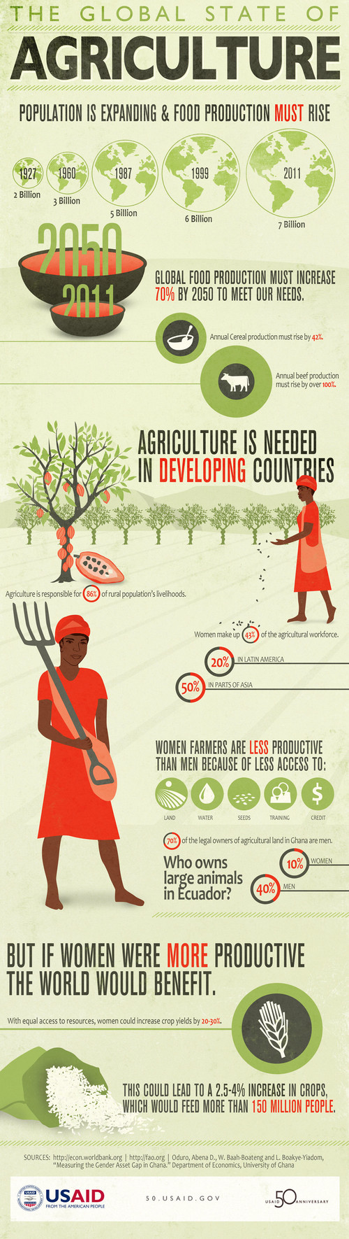
This fabulous collection of African maps from 1535-1897 represents an historical geographic vision of both Africa and colonial vision of Africa. I chose this particular map to display because it beautifully highlights the Mountains of Kong. For generations, European cartographers erroneously believed that this long mountain range extended north of the West African coast and across the continent. Currently this map collection is at Plymouth State, NH, but much of it is archive online here.
Tags: Africa, cartography, colonialism, map.
See on sites.google.com
Infographics on the distribution of wealth in America, highlighting both the inequality and the difference between our perception of inequality and the actua…
This video does have a political bent that may or may not reflect your views, but it nicely lays out data that graphically represents the economic differences that we see in the United States today. Our perception is as skewed as what is and what we think it should be.
See on www.youtube.com
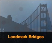
This conveys some important realities about the demographic necessities of agriculture, the economic impact and the cultural differences in agricultural production. As with all long infographics on this site, you can “scroll down” on the image by putting the cursor in the top right-hand corner of the image and sliding on the translucent bar.
Tags: agriculture, infographic, unit 5 agriculture.
See on 50.usaid.gov
The Pew U.S. Religious Landscape Study religion map diagrams which religions have the highest populations in each state.
The geography of religion, even in an era of secularization, is still a powerful indicator of many patterns of human geography. What is the religious profile of your state? What is the spatial distribution of the religious tradition with which you identify? What explains those spatial patterns?
Tags: USA, culture, diffusion, religion, Christianity.
See on religions.pewforum.org
Europe’s divisions are indeed grave. But counting the ex-communist countries as a single category is outdated and damaging
What places belong in a region together? What are the boundaries of that region? How has this region changed over time? Regional classification is inherently an exercise that relies on our geographic knowledge and requires some spatial thinking. Each semester I have students divide the United States into the regions that explain how they conceptualize the different parts of the country. This 2 minute video is a great example that argues that the regional category of Eastern Europe is less meaningful today mainly because of the changing political and economic geography that is blurring the regional borders of Europe.
See on www.economist.com
In the search for Middle East peace, the most fundamental problem is the problem of disbelief.
Wouldn’t you like to read the bullet points that accompany this graphic? This article written by a peace negotiator is a good “bi-partisan” approach to understanding what would be needed to actually achieve peace in the Middle East. The first step, is for both sides to believe that it can actually be achieved. Filling in a blank diagram such as this would be a great way to get students seeing the same dispute from multiple perspectives.
Tags: Israel, borders, Palestine, territoriality, political.
See on www.nytimes.com
Where in the world has 007 been in his 30 movies?
If that’s a question you’ve always wanted to know, then this set of maps was made just for you.
See on www.empireonline.com