Search

GEOGRAPHY EDUCATION

Supporting geography educators everywhere with current digital resources.

Author

sethdixon

I am a geography professor at Rhode Island College.

The Living Bridge


In North East India just north of Bangladesh is the province of Meghalaya.

This is an astounding video that shows a (literally) natural way that local people have adapted to an incredibly flood-prone environment to prevent erosion and to keep people in contact during times of flood.  The living bridges are truly a sight to behold.

Tags: environment, environment adapt, SouthAsia, water, weather climate, indigenous,

See on www.youtube.com

Urban Agriculture Sprouts in Brazil’s Favelas

Urban Agriculture Sprouts in Brazil’s Favelas – Organic agriculture is a growing trend in big cities around the world, including Latin America, and no…

This article nicely ties two commonly taught issues in human geography that aren’t the the typical combination: 1) the growth of organic farming and 2) the spread of squatter settlements and slums in the developing world. 

Tags: agriculture, food, urban, unit 5 agriculture, unit 7 cities

See on www.ipsnews.net

Spatial Thinking Key to Solving Crime

What are all these news reporters and school administrators doing in my classroom?  Monday, September 24, 2012 was most certainly an interesting day in my Mapping Our Changing World (GEOG 201) class…

One of my students applied some mapping skills and spatial analysis to a string of unsolved bank robberies in Rhode Island.  After 7 months of eluding capture with at least 8 robberies under his belt, the “bearded bandit” was aprehended less then 48 hours after my student handed over his analysis to a contact in the police department.  Coincidence?  I think not!  Great work Nic, showing that spatial thinking and geographic skills can be applied to a wide range of disciplines and activities.


Tags: RhodeIsland, GIS, mapping, GeographyEducation, edtech.   

See on geographyeducation.org

Exclusive Economic Zones

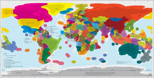
Today, a country’s marine economic area is defined by its Exclusive Economic Zone (EEZ), a 200-nautical mile-wide (370 km) strip of sea along the country’s national coast line (hi-res image). This regulation, which was installed by the ‘UN Convention on the Law of the Sea’ in 1982, grants a state special rights to exploit natural (such as oil) and marine (for instance fish) resources, including scientific research and energy production (wind-parks, for example).

Questions to ponder: how does this series of buffer zones around the Earth’s land masses impact politics, the environment and local economies?  Where might the EEZs be more important to the success of a country/territory than other regions? 

Tagseconomic, environment, political, resources, water, sovereignty, coastal, environment depend, territoriality, states, conflict, unit 4 political.  

See on td-architects.eu

The State of Women in the World

Tags: gender, development, worldwide, poverty.

See on armchairadvocates.com

Electoral Geography

Mitt Romney’s narrow electoral vote path explained — in 5 maps…

The above map represents the last time the Republican Party won a presidential election in the United States.  As the polls currently are projecting that President Obama will be re-elected, the most critical questions about the voting patterns for both parties are spatial in nature. 

Questions to ponder: how are current political patterns changing the map?  Which states become the most pivotal for either candidate to be victorious? 

Tags: political, regions, spatial, unit 4 political

See on www.washingtonpost.com

Climate Change Music Video

A musical video that serves as investigation into the causes and effects of global climate change and our opportunities to use science to offset it. Featuring Bill Nye, David Attenborough, Richard Alley and Isaac Asimov. “Our Biggest Challenge” is the 16th episode of the Symphony of Science series.  Visit http://symphonyofscience.com for more science remixes!

Tags: climatechange, environment, K12.

See on www.youtube.com

Earth from Above

I’m a huge fan of Yann Arthus-Bertrand‘s artistic aerial photography.  This image of Rio de Janeiro and the favela is a striking one. I am also posting this to show the how easy the website justpaste.it is to use.  Students with no website creation training can produce sharable materials online.  Now this isn’t the most professional outlet, but I envision some middle school or high school students producing a class project that can be transformed into something that reaches a bigger audience as it is shared with a broader community.


Tags: remote sensing, images, art, worldwide, K12, edtech.

See on justpaste.it

The New World

An interactive series of maps show possible new additions to the world’s list of independent nations.

This is great way to show examples of devolution and political instability.  Included are 11 potential scenarios where further fragmentation/disintegration might occur or even greater regional integration that would redraw the map.  These case studies include:

  • Somalia
  • Korea
  • Azerbaijan
  • Belgium
  • Arabian Gulf Union

Tags: political, devolution, supranationalism, war, autonomy, unit 4 political.

See on www.nytimes.com

Create a free website or blog at WordPress.com.

Up ↑