Search

GEOGRAPHY EDUCATION

Supporting geography educators everywhere with current digital resources.

Author

sethdixon

I am a geography professor at Rhode Island College.

Amazon’s New Push for Same-Day Delivery Will Destroy Local Retail

See on Scoop.itGeography Education

Amazon has long enjoyed an unbeatable price advantage over its physical rivals. When I buy a $1,000 laptop from Wal-Mart, the company is required to collect local sales tax from me, so I pay almost $1,100 at checkout.


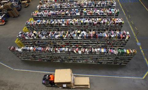
Just-in-Time production has reshaped the logistics of manufacturing.  How does same-day online delivery impact local retail businesses?  How might this change urban patterns of retail stores and of areas of warehouses?   

See on www.slate.com

Biggest transnational companies

See on Scoop.itGeography Education

THE giant American conglomerate General Electric (GE) holds more assets abroad than any other non-financial firm in the world—over $500 billion worth. Its foreign assets make up over 70% of its total.


While we may think of Volkswagen as a “German” company, 78% of their assets are in other countries. What advantages is there for companies to have operations in multiple countries? How do transnational corporations change the geographies of production, consumption and economics?

See on www.economist.com

8 Stunning One-Color Towns

See on Scoop.itGeography Education

“We’ve all heard about the colorful towns around the world, there are really lots of them and their facades are very colorful and striking. But, are there any towns that are painted in only one color? Of course there are, but they are very rare. Exactly, the following list deals with these unusual tourist destinations – a one-color towns, enjoy the article.”  Pictured is Izamal, Mexico on the Yucatan peninsula.     

See on www.theworldgeography.com

John Boyer (AKA The Plaid Avenger) on Poll Everywhere

See on Scoop.itGeography Education

John Boyer (http://www.youtube.com/user/Plaidcast) uses a variety of tech tools to teach thousands of students a year. Here’s his take on Poll Everywhere.


John Boyer’s teaching style and pedagogy as seen on http://plaidavenger.com/ have merged social media technologies deeply into the classroom, including http://www.polleverywhere.com/ and other great online resources.  This is the perfect example of how to create a social media classroom.  I had the privilege of speaking in the same conference session with John Boyer and Katie Pritchard earlier this year and this tag-team has really shifted the pedagogical paradigm.  For more in-depth blog post, see: http://blog.polleverywhere.com/professor-john-boyer-aka-the-plaid-avenger-on    

See on www.youtube.com

Rhode Island Stuck at Bottom of the List: Top States For Business

See on Scoop.itGeography Education

The Ocean State didn’t just place last in our overall rankings for the second year in a row, it also finished in the bottom five of four individual categories in 2012.  A  little Providence, please.

The business leaders and politicians in Rhode Island are working hard to attract more investment and greater job opportunities.  Rhode Island’s only neighbors, Connecticut and Massachusetts attract massive amounts of venture capital compared to the Ocean State (per capita as well, so Rhode Island can’t just claim that it’s a matter of scale). With 11% unemployment (2nd worst in the country), the economic geography of Rhode Island has problems.  What factors have led to this economic situation?  Possible solutions?

See on www.cnbc.com

The Geography of Foreign Aid

See on Scoop.itGeography Education

This map is a graphical representation of the Dashboard’s available data on foreign assistance appropriations by fiscal year. The darker a country’s shading appears on the map, the more funding that U.S. Government country office received in that fiscal year. Users can switch between fiscal years by using the dropdown box in the top right corner of the page. Users can choose a country by clicking the map or by selecting the name of the country from the drop down box above.

See on www.foreignassistance.gov

OverlapMaps – Instantly compare any two places on Earth!

See on Scoop.itGeography Education

An OverlapMap is a map of one part of the world that overlaps a different part of the world. OverlapMaps show relative size.


The above overlap map is the United Kingdom compared to the state of Pennsylvania.  This is an very simple way to demonstrate the true size of remote places, and ‘bring the discussion home.’  This site is as simple and intuitive as it is powerful and easily applicable.  This is a keeper.  

See on overlapmaps.com

The United Shapes of America

See on Scoop.itGeography Education

This is clever.

See on xkcd.com

Grocery Store Wars

See on Scoop.itGeography Education

Not long ago in a supermarket not so far away. Help fight the dark side of the farm. Rate the film, favorite the film, comment the film and subscribe to our …


This is horribly cheesy and from an incredibly biased perspective, but it does embody how many see the organic movement (and is quite entertaining for old Star Wars buffs like me). 

See on www.youtube.com

Create a free website or blog at WordPress.com.

Up ↑