Search

GEOGRAPHY EDUCATION

Supporting geography educators everywhere with current digital resources.

Category

Scoop.it

The Origin of Krampus, Europe’s Evil Twist on Santa

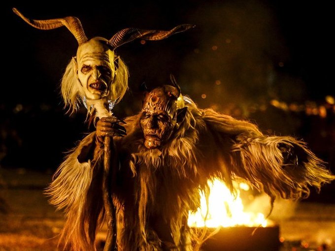
The mythical holiday beast is once again on the prowl, but beware, he’s making his way across the Atlantic

Source: www.smithsonianmag.com

Questions to Ponder: So what kind of cultural diffusion is this?  Expansion diffusion, contagious diffusion, stimulus diffusion or hierarchical diffusion?  Why so?


Is this more as a pop culture phenomenon or a revitalization of a folk cultural tradition?  How come?


Tags: religion, Europeculture, historical.

The Danger of a Single Story

https://www.youtube.com/v/D9Ihs241zeg?fs=1&hl=fr_FR

Our lives, our cultures, are composed of many overlapping stories. Novelist Chimamanda Adichie tells the story of how she found her authentic cultural voice — and warns that if we hear only a single story about another person or country, we risk a critical misunderstanding.

Source: www.youtube.com

To gain a global perspective inherently requires understanding multiple perspectives.  Africa is frequently portrayed as ‘the other’ but also homogenized within a single narrative that ‘flattens’ truth.  How can we teach and learn about other places in a way that develops geographic empathy and shows the many stories of that can belong to any one place? 

Tags: Africa, perspective, TED.

GeoInquiries for Human Geography

GeoInquiries are designed to be fast and easy-to-use instructional resources that incorporate advanced web mapping technology. Each 15-minute activity in a collection is intended to be presented by the instructor from a single computer/projector classroom arrangement. No installation, fees, or logins are necessary to use these materials and software.

Source: edcommunity.esri.com

ESRI has produced GeoInquires for Earth Science, History and now AP Human Geography.  If you try out an APHG GeoInquiry, please take a moment or two to give the folks at ESRI some feedback. They are especially looking for reviewers for the GeoInquiries for 1) Distance, transportation, and scale 2) USA Demographics and 3) Agricultural Patterns.  If can get a free ESRI book for your time by assisting them in refining these educational resources.

Tags physicalmappinggeospatialESRI, APHG.

GeoInquiries for Human Geography

GeoInquiries are designed to be fast and easy-to-use instructional resources that incorporate advanced web mapping technology. Each 15-minute activity in a collection is intended to be presented by the instructor from a single computer/projector classroom arrangement. No installation, fees, or logins are necessary to use these materials and software.

Source: edcommunity.esri.com

ESRI has produced GeoInquires for Earth Science, History and now AP Human Geography.  If you try out an APHG GeoInquiry, please take a moment or two to give the folks at ESRI some feedback.


Tags physical, mapping, geospatialESRI, APHG.

U.S. Hispanic and Asian populations growing, but for different reasons

Both Hispanics and Asians been among the fastest-growing racial/ethnic groups in recent years, but since 2010, number of Asians have increased at a faster rate.

Source: www.pewresearch.org

It is often noted that the cultural composition of the United States is undergoing a shift, referred to by some as the “Browning of America.”  The story of Asian and Hispanic growth in the United States are occurring simultaneously, which makes many assume that they are growing for the same reasons.  The data clearly shows that this is not the case.  

Tags: migration, USA, ethnicity.

Why do competitors open their stores next to one another?

“Why are all the gas stations, cafes and restaurants in one crowded spot? As two competitive cousins vie for ice-cream-selling domination on one small beach, discover how game theory and the Nash Equilibrium inform these retail hotspots.”

Source: www.youtube.com

This TED-ED lesson shows the economic and spatial factors that lead to businesses to cluster together.  This video is a very simple introduction to the concept of agglomeration that is based on competition.


Tags: APHGTED, models, spatialK12, location.

Yes, Yellowstone’s Roads Just Melted. No, There’s No Reason to Panic

“Last week, a major tourist thruway in Yellowstone National Park had to be shut down because the road melted. The road’s Wicked Witch of the West impression was caused by high temperatures in both the air and under the ground. Yellowstone sits atop a volcanic hotspot, and that heat helped cause the asphalt to soften and oil to well up onto the surface.”

Source: www.smithsonianmag.com

The Toll in Gaza and Israel, Day by Day

The daily tally of rocket attacks, airstrikes and deaths in the conflict between Israel and Hamas.

Source: www.nytimes.com

As the violent nature of the Israeli Palestinian conflict has escalated, this NY Times article monitors the major points of the last few weeks.  The possibility of ‘Peace in the Middle East’ feels so remote, and this Onion article parodies the difficulties of actually achieving this.  On a personal note, Chad Emmett taught the “Geography of the Middle East” course while I was at BYU and I’ve always appreciated his perspective; here are his thoughts on recent events.  


Tags: Israel, Palestine, conflict, political, borders.

Satellites Are Now Cleared to Take Photos at Mailbox-Level Detail

The Department of Commerce just lifted a ban on satellite images that showed features smaller than 20 inches. The nation’s largest satellite imaging firm, Digital Globe, asked the government to lift the restrictions and can now sell images showing details as small as a foot. A few inches may seem slight, but this is actually a big deal.

Source: gizmodo.com

As reported by the BBC, this change in the legal use of geospatial information could have a huge impact on many industries.  Some are fearful that it could represent an invasion of privacy, and others see this as a way to harness new satellite technology to provide higher resolution data and improved data quality for researchers. 

Tagsmappingimages, remote sensing, geospatial.

Create a free website or blog at WordPress.com.

Up ↑