Search

GEOGRAPHY EDUCATION

Supporting geography educators everywhere with current digital resources.

Category

Scoop.it

World War II Led to a Revolution in Cartography

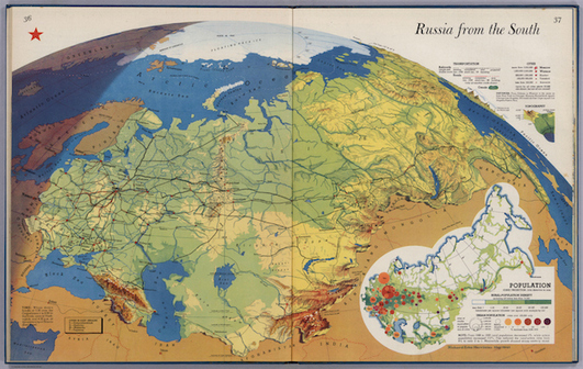
“More Americans came into contact with maps during World War II than in any previous moment in American history. From the elaborate and innovative inserts in the National Geographic to the schematic and tactical pictures in newspapers, maps were everywhere. On September 1, 1939, the Nazis invaded Poland, and by the end of the day a map of Europe could not be bought anywhere in the United States. In fact, Rand McNally reported selling more maps and atlases of the European theaters in the first two weeks of September than in all the years since the armistice of 1918. Two years later, the attack on Pearl Harbor again sparked a demand for maps.”

Source: www.newrepublic.com

Author of Mapping the Nation, Susan Schulten explains how historical events created a huge demands for maps, revolutionizing the industry and leading to many new ways of visualizing the world.  

Tags: historical, mapping, war.

Challenges in Defining an Israeli-Palestinian Border

There are major hurdles in drawing borders between Israel and a future Palestine.

Israeli and Palestinian negotiators resumed peace talks in Washington in July for the first time in three years. While the talks are initially expected to focus on procedural issues, they are already beginning to take on a last-ditch quality. Explore some of the contentious issues that negotiators have faced in drawing borders between Israel and a future Palestinian state.

Source: www.nytimes.com

This five-part video report from the New York Times is from 2011, but still has some pertinent information, even if the situation has changed in some of the particulars.  These videos brings important voices from a variety of perspectives on the Israeli-Palestinian conflict; together they all  show how a complex cultural and political geography leads to many of the difficulties in creating a long-lasting peace.  The discipline of geography doesn’t simple study the peace process–it is a part of it.  The creation of borders and the cartographic process play a critical role in solving territorial issues.  Geography can be both the problem and the solution. 

Tags: Israel, borders, Palestine, territoriality, political, Middle East.

Visualizing Time and Space

Source: xkcd.com

The question, “what time is it?” does not have one right answer.  The correct answer is dependent on your location on the Earth and the cultural and political conventions of the society in which live.  Don’t mistake a cartoon for a map without substance.


Tags: map, perspective.

Global Multidimensional Poverty Index

“The global Multidimensional Poverty Index (MPI) is an international measure of acute poverty covering over 100 developing countries. It complements traditional income-based poverty measures by capturing the severe deprivations that each person faces at the same time with respect to education, health and living standards.”

Source: www.ophi.org.uk

The MPI was developed out of a desire to fill some of the gaps in the HDI’s applicability and utility.  Allow me to quote the editor of one the NCGE’s journals, the Geography Teacher, on the usefulness of the MPI website for classroom use: “With the infographics, maps, graphs, country briefings, and case studies, you have a ready-made lesson activities to demonstrate patterns of fertility, mortality, and health for a population unit, and access to health care, education, utilities, and sanitation for an Industrialization and Economic Development Unit. Connections can also be made to malnutrition and water, as well as to key concepts such as pattern and scale, to key geographical skills such as how to use and think about maps and geospatial data, and to the use of online maps and online data.”  Also, this article from the World Bank also give a run-down on the key findings of the MPI in 2014. 

Tags: statisticspopulation, development, unit 2 population, unit 6 industry.

Refugee Camp for Syrians in Jordan Evolves as a Do-It-Yourself City

As the sprawling Zaatari camp evolves into an informal city — with an economy and even gentrification — aid workers say camps can be potential urban incubators that benefit host countries like Jordan.

Source: www.nytimes.com

This is an intriguing article that explores the difficulties of forced migrations that arise from civil war, but it also looks at city planning as refugee camps are established to make homes for the displaced.  These camps have become into de-facto cities. The maps, videos and photographs embedded in the article show the rapid development of these insta-cities which organically have evolved to fit the needs of incoming refugees.  Size not investing in permanent infrastructure has some serious social, sanitation and financial cost, there are some efforts to add structure to the chaos, to formalize the informal.  Truly this is a fascinating case study of in urban geography as we are increasingly living on what Mike Davis refers to as a “Planet of Slums.”  


Tags: refugees, migration, conflict, political, warsquatter, urban, planning, density, urbanism, unit 7 cities. 

An Intriguingly Detailed Animation of How People Move Around a City

Watch the commuting patterns of New York, San Francisco and Los Angeles.

Source: www.citylab.com

This CityLab article and the embedded maps show the rhythms and patterns that make city life so beautifully complex.  The Center for Advances Spatial Analysis has compiled numerous maps, time-lapse videos and other animations to show flows of urban life.  These are great resources to visualize the ‘spaces of flows.’  

Tags: mobility, mapping, visualization, urban, planning, unit 7 cities, transportation.

Drought Drains Lake Mead to Lowest Level

“The largest reservoir in the U.S. falls to its lowest water level in history, Nevada State Sen. Tick Segerblom introduced a bill title and issued a press release on July 8 calling for an ‘independent scientific and economic audit of the Bureau of Reclamation’s strategies for Colorado River management.'”

This week’s history-making, bad-news event at Lake Mead has already triggered lots of news stories, but almost all of these stories focus on the water supply for Las Vegas, Phoenix and California. But what about the health of the river itself?

Tags: physicalfluvial, drought, water, environment.

Source: ecowatch.com

Ethiopia’s Dam Problems

“Ethiopia is three years from completing a dam to control its headwaters, and while Egypt points to colonial-era treaties to claim the water and to stop the project, the question remains as to who own the Blue Nile.”

Source: maps101blog.com

This 7-minute Geography News Network podcast (written by Julie and Seth Dixon) touches on some key geographic concepts.  85% of the Nile’s water comes from the Blue Nile that originates in the Ethiopian highlands–it is the Blue Nile that Ethiopia has been working on damming since 2011.  The Grand Ethiopia Renaissance Dam (GERD) will be located  near the border with Sudan.  Egypt is adamantly opposed to Ethiopia’s plan and is actively lobbying the international community to stop construction on the dam, fearing their water supply with be threatened. 

Tags: Ethiopia, Africa, development. environment, water, energy, borders, political.

Chinese Uyghurs defy Ramadan ban

“The government’s attempt to clamp down on religious expression has backfired among Uyghurs.”

Source: www.aljazeera.com

China has used various means to eliminate minority groups’ cultural identity, and human rights groups argue that this ban on Ramadan is no different (children and government employees are banned from fasting, allegedly for health and safety concerns).  Ethnic Uyghurs speak a Turkic language are more culturally connected to Cental Asia than East Asia.  Predominantly Muslim, the Uyghurs are defying some of the more controversial laws that they feel single them out.   


Tagsethnicityconflict, politicalreligion, China.

Create a free website or blog at WordPress.com.

Up ↑