Search

GEOGRAPHY EDUCATION

Supporting geography educators everywhere with current digital resources.

Category

Scoop.it

Welcome to Baku, the Fiercely Modern, Millennia-Old, Capitalist-Socialist, Filthy-Rich Capital of Azerbaijan

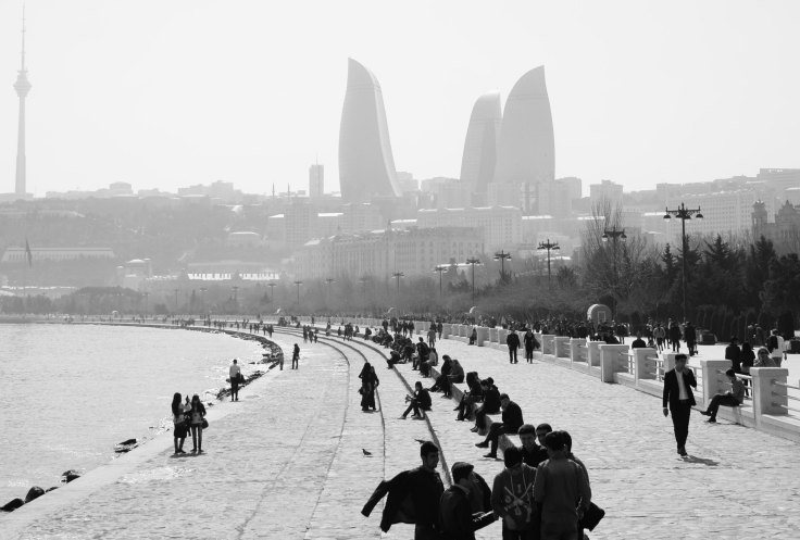
“Since 2006, when the opening of the Baku-Tbilisi-Ceyhan pipeline prompted a surge in crude oil exports — up to a million barrels a day travel through neighboring Georgia and on to Turkey and the West — there’s been no shortage of cash in Baku. Now, the city is eager for the prestige that goes with it.”

Source: www.bloomberg.com

Baku is described in this article as an East-West, socialist-capitalist, Muslim-secular, ancient-modern mishmash due to the numerous cultural and political interactions that it has had.  This makes for a fascinating cultural landscape emerging in a city that has been dubbed “the Dubai of the Caucasus” but still has a rich Silk Road history.  Caspian Sea oil lies at the heart of Azerbaijan’s geopolitical importance and cultural aspirations. 


Tags: Azerbaijan, political, Central Asia.

This 19th Century Map Could Have Transformed the West

Today’s drought-riven west would look very different if Congress had listened to John Wesley Powell

Source: www.newrepublic.com

Author of Mapping the Nation, Susan Schulten explains how western expansion failed to recognize the basic physical geographic reality of the United States–that the west is much drier than the east.  Given that much of the west, especially California, is in the midst of a severe drought, this article serves as a reminder to recognize that localized understandings of human and environmental actions are necessary.  Do you know what watershed you live in?  How does and should that impact us?   


Tags: physical, historical, California, water, environment.

Maximum Summer Heat

A new analysis shows when summer reaches peak heat across the U.S.

Tags: physical, weather and climate, seasonal.

Source: www.climatecentral.org

NASA and the World Cup

“NASA goes to the World Cup! Satellite imagery from each country playing.”

Source: www.arcgis.com

Not that we need any extra incentive to view NASA’s gorgeous satellite imagery, but now that the World Cup has entered the knockout rounds, it is the perfect opportunity to view selected images from the participating countries.  This gallery of a dozen World Cup StoryMaps are but a few of the thousands of Esri StoryMaps that can serve as motivation to get your K-12 U.S. school an organizational account for ArcGIS online (then your students can make cool maps like these). 


Tags: sport, Brazil, South America, Esri, fun, mapping, remote sensing, geospatial, images, perspective.

The Language of Maps Kids Should Know

The vocabulary and concepts of maps kids should learn to enhance their map-skills & geography awareness. Concise definitions with clear illustrations.

Source: kidworldcitizen.org

I really like this article because it briefly shares the language needed for students to able to successfully use maps in the classroom…plus it’s highly adaptable for virtually any grade level.   


Tagsmapping, K12, scale, location.

Beijing’s Facelift

“A government-initiated redevelopment plan will transform one of the oldest neighborhoods in Beijing into a polished tourist attraction.”

Source: www.youtube.com

This 2010 video (and related article) showcases one of China’s urban transformation projects.  Urban revitalization plans are not without critics, especially those who see the cultural transformation of a neighborhood they deem worthy of historical preservation.  This process is occurring all over the world (we’ve recently seen this in Brazil as they were preparing for the World Cup).  This is one of the videos that I’ve put into my interactive map with over 65 geography videos to share in the classroom.
 

Developing World Cities and Population Density

Without a question, we are living in an urban era. More people now live in cities than anywhere else on the planet and I’ve repeatedly argued that cities are our most important economic engine. As a result of these shifts, we’re seeing megacities at a scale the world has never seen before.

Source: sustainablecitiescollective.com

As our cities have massively expanded in the last 70 years, so has the ecological footprint of these metropolitan areas.  This article discusses some of the challenges confronting megacities and their functions within the global urban network. 

Tags: sustainabilitydensity, megacities, housing, urban, planning, unit 7 cities. 

China’s territorial claims

One of the geography videos embedded in this interactive map: http://bit.ly/KDY6C2

Source: www.youtube.com

Suspicions between the People’s Republic of China and its neighbors bedevil its boundaries to the east, south and west as shown in this videographic from the Economist.  This is one of the videos that I’ve put into my interactive map with over 65 geography videos to share in the classroom

Tags: borders, political, conflict, waterChina, East Asia.

America’s recent drought history, animated

“California’s drought just hit a new milestone: As of this week, 32.98 percent of the state is experiencing “exceptional” drought, making it the worst drought in the 14 years that the Department of Agriculture’s Drought Monitor has tracked data.”

Source: www.washingtonpost.com

The recent drought in California has only deepened and this Washington Post article shows an animated map that highlights the temporal and spatial patterns in the drought data (hint–it’s not pretty).  In a related note, May 2014 was the hottest May in recorded history.     

Questions to Consider: What are some reasons (both from human and physical geography) for this severe drought? What can be done in the short-term to lessen the problem? What can be done to make California’s water situation better for the next 50 years?

Tags: physical, weather and climate, consumptionCalifornia, water, environment, resources, environment dependurban ecology.

Create a free website or blog at WordPress.com.

Up ↑