Some of these will surprise you.
Source: www.businessinsider.com
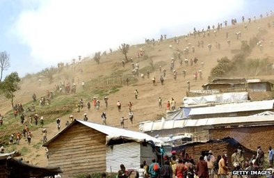
The Democratic Republic of Congo is potentially one of the richest countries on earth, but colonialism, slavery and corruption have turned it into one of the poorest
Source: www.bbc.com
One thing that baffles many students is how a resource-rich region can be an area of underdevelopment and poverty. Understanding the historical geography is key for students being able to see that natural wealth does not correlate to enriching the local population. Kinshasa, the capital that seemed so promising as the site of the famous “Rumble in the Jungle between Ali and Frazier, is now a city of chaos.
Tags: Congo, political, conflict, resources, political ecology, Africa.
“New York has long been a city of immigrants, but linguists now consider it a laboratory for studying and preserving languages in rapid decline elsewhere in the world.”
Source: www.youtube.com
This is an excellent video for showing the diffusion of languages in the era of migration to major urban centers. It also shows the factors that lead to the decline of indigenous languages that are on the fringe of the global economy and the importance of language to cultural traditions. Here is the article related to the video as well as a BBC article that calls NYC a ‘graveyard of languages.’ In a curious twist on the topic of endangered languages, there is a group of Native Americans in Northern California that wouldn’t mind seeing their language die out with this generation.
Tags: language, folk cultures, culture, diffusion, NYC, video.
What do you do when presented with a new satellite image? Here’s what the Earth Observatory team does to understand the view.
Question #2: READ TO ANSWER FOR MORE INFO ON THE FIVE TIPS: earthobservatory.nasa.gov
Question #3: Also search through NASA’s Earth Observatory (Images or Articles) and the Jefferson Grid Instagram account..
Aerial photography can be quite beautiful, as can satellite imagery. These are more than just pretty pictures; interpreting aerial photography and satellite imagery is not easy; here is a great article that gives an introduction on how to interpret satellite imagery. With a little training, satellite images become rich data sources (instead of some visually meaningless data). Using Stratocam, you can explore and tag some of the amazing place on Earth.
Source: earthobservatory.nasa.gov
Tags: mapping, perspective, remote sensing, geospatial, unit 1 Geoprinciples.
Stunning satellite images and maps show how east and west differ from each other even today.
Source: www.washingtonpost.com
These two maps (unemployment on the left and disposable income on the right) are but two examples in this article that highlights the lingering distinctions between the two parts of Germany that were reunited 25 years ago. The social geographies imposed by the Iron Curtain and the Berlin Wall are still being felt from this relic border and will for years to come.
Tags: Germany, industry, labor, economic, historical, political, borders.
“Stratfor Eurasia Analyst Eugene Chausovsky examines the Caspian Sea’s large energy reserves and its conflicting maritime boundaries.”
Source: www.youtube.com
After the collapse of the Soviet Union, the world’s largest lake went from having just two countries on its shores to five. Dividing the maritime borders has been especially difficult since the Caspian Sea has rich energy reserves and this lake will remain a place of strategic interest for many regional powers. This video has been added to my ESRI StoryMap that spatially organizes place-based videos for the geography classroom.
Tags: borders, political, geopolitics, Central Asia, energy, resources, Kazakhstan, Azerbaijan, Iran, Russia, economic, water.
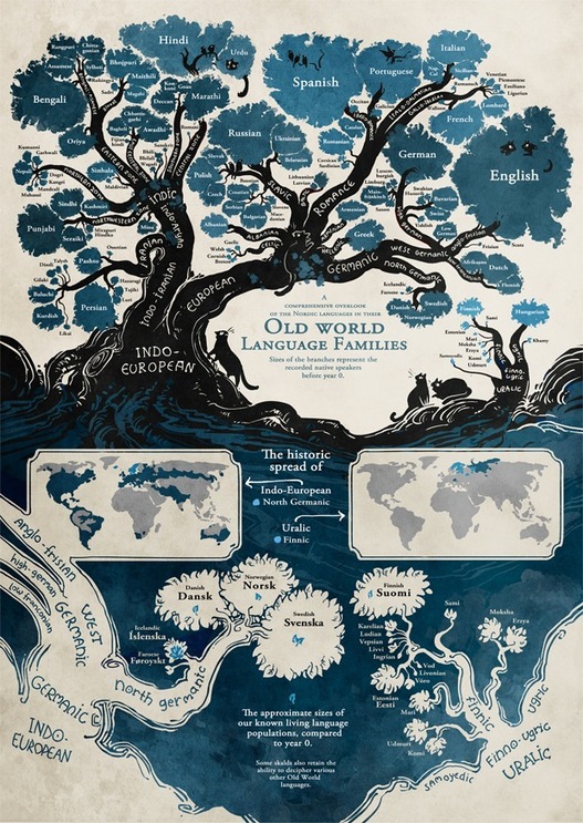
“When linguists talk about the historical relationship between languages, they use a tree metaphor. An ancient source (say, Indo-European) has various branches (e.g., Romance, Germanic), which themselves have branches (West Germanic, North Germanic), which feed into specific languages (Swedish, Danish, Norwegian). Minna Sundberg, creator of the webcomic Stand Still. Stay Silent, a story set in a lushly imagined post-apocalyptic Nordic world, has drawn the antidote to the boring linguistic tree diagram.”
Source: mentalfloss.com
Languages are interconnected and often share common roots and ancestries. This artistic rendering of the Indo-European language tree (Hi-Res) is an attempt to visually show the linguistic connections between languages and language families.
Tags: language, art, culture, infographic.
“Most state borders were drawn centuries ago, long before the country was fully settled, and often the lines were drawn somewhat arbitrarily, to coincide with topography or latitude and longitude lines that today have little to do with population numbers. Most state borders were drawn centuries ago, long before the country was fully settled, and often the lines were drawn somewhat arbitrarily, to coincide with topography or latitude and longitude lines that today have little to do with population numbers.”
Tags: cartography, mapping, visualization, regions, gerrymandering, political, mapping, census, density.
Source: www.slate.com
We know where the bodies are buried … take a virtual tour of world cemeteries that host famous artists and rogues
Tag: cemetery.
Source: www.smithsonianmag.com